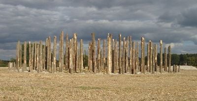
Woodhenge, Neolithic henge site in Wiltshire, England
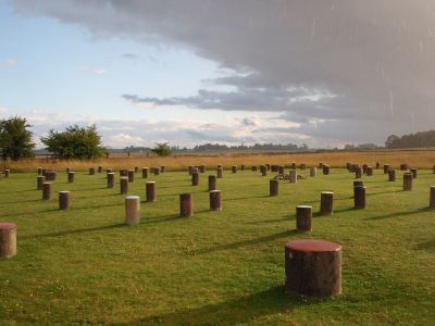
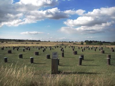
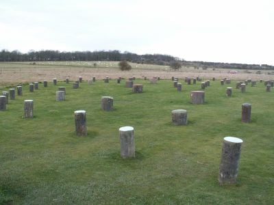
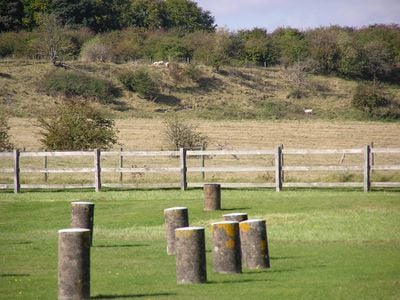
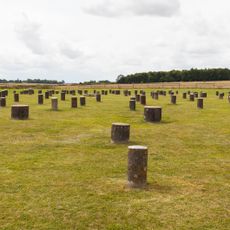
Woodhenge is a prehistoric monument from the Neolithic period made of concentric rings of wooden posts. The structure was surrounded by a circular bank and ditch, and concrete markers now show where the wooden posts once stood.
The monument dates from the Neolithic period and remained hidden underground until aerial photography in the 1920s revealed its location. This discovery showed that the site had been completely unknown for thousands of years.
The name refers to the wooden posts that once stood at this location, which visitors can still imagine today. The circular arrangement reveals that people gathered here for communal occasions and important gatherings.
The site is easy to access and the concrete markers help you understand the original layout even though no wooden posts remain. Visitors can walk around the circular formation, and the ground is relatively flat and accessible.
Excavations uncovered the remains of two burials, including a child placed at the center of the post circles. This discovery shows the site served not just for gatherings but also for burial ceremonies.
Location: Durrington
Fee: No
Part of: Stonehenge, Avebury and Associated Sites, Henge monuments at Durrington Walls and Woodhenge, a round barrow cemetery, two additional round barrows and four settlements
Website: https://english-heritage.org.uk/visit/places/woodhenge
GPS coordinates: 51.18963,-1.78674
Latest update: December 17, 2025 10:19
Durrington Walls
416 m
Cuckoo Stone
348 m
Henge monuments at Durrington Walls and Woodhenge, a round barrow cemetery, two additional round barrows and four settlements
197 m
Buildings 455 and 456 (Five Aircraft Hangars), Durrington Camp
722 mBowl barrow 80m north of the A303, north east of Vespasian's Camp
1.2 kmStables And Barn At Countess Farm
1.3 kmLarge Barn At Countess Farm
1.3 kmBowl barrow 510m south east of Strangways on Countess Farm
700 mSmall Granary To North Of Large Barn At Countess Farm
1.3 kmBowl barrow 150m west of A345 on Countess Farm
469 mBowl barrow 200m south west of Strangways forming part of a linear round barrow cemetery known as the Old King Barrows
1.2 kmBowl barrow 450m north of the A303, on Countess Farm
914 mBowl barrow 400m north of the A303 on Countess Farm
907 mBowl barrow 260m north of the A303 on Countess Farm
1.1 kmTwo bowl barrows 800m north east of The Avenue on Countess Farm
835 mBowl barrow 60m west of A345 on Countess Farm
477 mBowl barrow 140m north of the A303 on Countess Farm
1.2 kmBowl barrow 170m south east of Strangways on Countess Farm
892 mPond barrow 400m south east of Strangways
713 mBowl barrow 500m north of the A303 on Countess Farm
967 mLong barrow 450m WSW of Woodhenge
382 mBowl barrow 250m north of the A303 on Countess Farm
1.1 kmCountess Farmhouse And Front Garden Walls
1.3 kmLarge Granary At Countess Farm
1.3 km
Toll Cottage
1.1 kmBowl barrow 800m north east of The Avenue on Countess Farm
766 mBCAC Hanger
716 mBCAC Hanger
724 mVisited this place? Tap the stars to rate it and share your experience / photos with the community! Try now! You can cancel it anytime.
Discover hidden gems everywhere you go!
From secret cafés to breathtaking viewpoints, skip the crowded tourist spots and find places that match your style. Our app makes it easy with voice search, smart filtering, route optimization, and insider tips from travelers worldwide. Download now for the complete mobile experience.
A unique approach to discovering new places❞
— Le Figaro
All the places worth exploring❞
— France Info
A tailor-made excursion in just a few clicks❞
— 20 Minutes