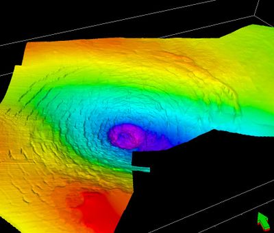
Silverpit crater, Impact crater in North Sea, United Kingdom.
Silverpit crater is an underwater formation beneath the North Sea, situated roughly 1,500 meters (4,900 feet) below the seafloor in sedimentary layers. The structure displays multiple concentric rings spanning approximately 20 kilometers (12 miles) in diameter.
Petroleum geoscientists first identified this formation in 2002 through analysis of seismic data collected during routine gas exploration activities. The discovery emerged from data gathered while searching for hydrocarbon resources in the area.
The name comes from nearby fishermen who long ago called a depression on the sea floor Silver Pit, referring to the lighter appearance of the sediment. Local maritime communities have known about this area for generations, though they only recognized it as a topographic feature rather than an impact site.
The formation lies roughly 130 kilometers (80 miles) from the Humber estuary and can only be studied with specialized research vessels. Work at the site requires advanced sonar equipment and favorable sea conditions.
Scientists have debated the true cause of this formation since its discovery, as both a meteorite impact and salt dissolution could explain how it formed. This uncertainty makes the location particularly interesting for researchers, as the answer could reshape understanding of this region's geological history.
The community of curious travelers
AroundUs brings together thousands of curated places, local tips, and hidden gems, enriched daily by 60,000 contributors worldwide.