Enable Location

We need your location to show you interesting places around you

Discover nearby places

Find interesting locations and hidden gems around you

Precise directions

Get accurate directions and distances to places

Your location is never shared with other users. It's only used when you tap the location button.

Manchester Ship Canal

Log in to your account

Start exploring — it's free

Trusted by 61,563 travelers worldwide

Continue with Google
Continue with Apple
or

We will send you a code to connect

By continuing, you accept our Terms and Conditions and our Privacy Policy

Check your inbox

We've sent a pincode in your inbox. Please enter the code below.

Manchester Ship Canal

Manchester Ship Canal, Industrial waterway in Greater Manchester, England

Description

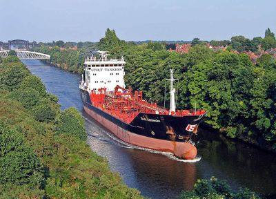
The Manchester Ship Canal is a waterway in Greater Manchester that connects the city with the sea over 36 miles. Five lock systems allow ships to travel between the inland area and the Irish Sea.

History

The opening took place in 1894 after years of construction and overcame economic and technical obstacles. The project turned the city into the third largest port in Britain and changed trade routes permanently.

Culture

The waterway once turned the city into an inland port and gave it direct access to global trade routes. This economic shift shaped generations of workers and changed the identity of the entire region.

Practical

The canal remains active today and carries cargo ships and tankers through the locks. Visitors can walk along the towpaths and watch ships pass or see the lock systems in operation.

Did you know?

A movable aqueduct carries an older canal over the water and swings aside when larger ships need to pass. This technical solution from the 19th century is still in operation today.

Location
Official opening
May 21, 1894
GPS coordinates
53.40348,-2.46241
Latest update
December 12, 2025 23:14

AroundUs brings together thousands of curated places, local tips, and hidden gems, enriched daily by 60,000 contributors worldwide. Discover all places nearby (Manchester).

Around this place
St Werburgh's Church, Warburton
United Kingdom

St Werburgh's Church, Warburton

1.3 km
Lymm Cross
United Kingdom

Lymm Cross

2.7 km
St Peter's Church, Oughtrington
United Kingdom

St Peter's Church, Oughtrington

2.6 km
Bent Farmhouse, Warburton
United Kingdom

Bent Farmhouse, Warburton

1.2 km
16, Bridgewater Street
United Kingdom

16, Bridgewater Street

2.7 km
War Memorial in St Werburg's Churchyard
United Kingdom

War Memorial in St Werburg's Churchyard

1.2 km
Church of St Helen
United Kingdom

Church of St Helen

1.5 km
The Bridgewater Canal Grantham's Bridge
United Kingdom

The Bridgewater Canal Grantham's Bridge

2.5 km
The Bridgewater Canal Lloyd Bridge
United Kingdom

The Bridgewater Canal Lloyd Bridge

2.3 km
Bridge over outfall and spillway, Lymm Dam
United Kingdom

Bridge over outfall and spillway, Lymm Dam

3 km
Old Church of Saint Werburg
United Kingdom

Old Church of Saint Werburg

372 m
The Bridgewater Canal Bridgewater Street Aqueduct
United Kingdom

The Bridgewater Canal Bridgewater Street Aqueduct

2.7 km
Milestone
United Kingdom

Milestone

889 m
War Memorial
United Kingdom

War Memorial

1.5 km
Milestone
United Kingdom

Milestone

2.4 km
Number 1 with attached screen wall, steps and railings
United Kingdom

Number 1 with attached screen wall, steps and railings

2.6 km
The Bridgewater Canal Burford Lane Aqueduct
United Kingdom

The Bridgewater Canal Burford Lane Aqueduct

2.6 km
Stocks at Lymm Cross
United Kingdom

Stocks at Lymm Cross

2.7 km
Lodge to Lymm Grammar School
United Kingdom

Lodge to Lymm Grammar School

3 km
1A and 3, Lymm Bridge
United Kingdom

1A and 3, Lymm Bridge

2.6 km
Milestone
United Kingdom

Milestone

1.3 km
Burford Lane Warehouse And House Attached
United Kingdom

Burford Lane Warehouse And House Attached

2.7 km
Lychgate, old church of Saint Werburg
United Kingdom

Lychgate, old church of Saint Werburg

405 m
Lymm Slitting Mill
United Kingdom

Lymm Slitting Mill

2.6 km
Milestone, Manchester Road; Rixton; 100m W Holly Bush Lane opp. No. 24
United Kingdom

Milestone, Manchester Road; Rixton; 100m W Holly Bush Lane opp. No. 24

2.4 km
Milestone, Liverpool Road, almost opp. No. 252
United Kingdom

Milestone, Liverpool Road, almost opp. No. 252

898 m
Milestone, Liverpool Road, Hollins Green; opp. Ye Olde Red Lion in garden of no 505
United Kingdom

Milestone, Liverpool Road, Hollins Green; opp. Ye Olde Red Lion in garden of no 505

1.3 km
Rixton Clay Pits
United Kingdom

Rixton Clay Pits

1 km
Show the full map
« Manchester Ship Canal - Industrial waterway in Greater Manchester, England » is provided by Around Us (aroundus.com). Images and texts are derived from Wikimedia project under a Creative Commons license. You are allowed to copy, distribute, and modify copies of this page, under the conditions set by the license, as long as this note is clearly visible.

Discover hidden gems everywhere you go!

From secret cafés to breathtaking viewpoints, skip the crowded tourist spots and find places that match your style. Our app makes it easy with voice search, smart filtering, route optimization, and insider tips from travelers worldwide. Download now for the complete mobile experience.

Around Us App Screenshot

A unique approach to discovering new places

Le Figaro

All the places worth exploring

France Info

A tailor-made excursion in just a few clicks

20 Minutes

Around Us
Travel Guide & Maps
Download

Send to your phone

QR Code
1

Open the camera app on your mobile.

2

Point at the QR code with your camera. A notification will appear.

3

Tap the notification to open the link.