Godalming, Market town in Surrey, England
Godalming is a market town in Surrey, England, that stretches along the banks of the River Wey and lies within the Surrey Hills National Landscape. The built environment comprises more than 350 listed structures spread across five conservation areas that define the historic core of the settlement.
The settlement was founded during the Saxon period and received a royal charter from King John in 1207, which secured its status as a trading place. Over the following centuries, the town developed into a center for textile production and later leather processing, until industry declined in the 20th century.
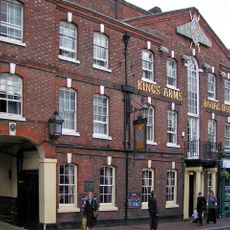
Residents use the old structures along the high street for cafes, shops and events, with the historic facades shaping the character of the place. The octagonal pavilion in the town center serves today as a meeting point and landmark for visitors and locals alike.
The railway station sits at the southern edge of the settlement and allows direct connections to London and the coast. Several bus lines connect the surrounding area, so visitors can reach neighboring villages and walking areas in the hills without a car.
In 1881, the world's first public electric street lighting was installed here, which also supplied private homes with power. This experiment lasted only a few years but laid the foundation for later developments in urban electrification.
The community of curious travelers
AroundUs brings together thousands of curated places, local tips, and hidden gems, enriched daily by 60,000 contributors worldwide.