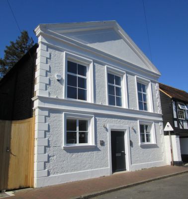
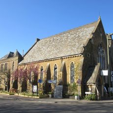
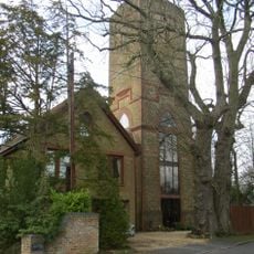
Salvation Army Hall, Godalming, Grade II listed religious building in Godalming, England.
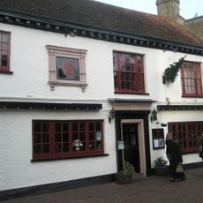
Salvation Army Hall is a Grade II listed building in Godalming constructed around 1830, positioned on Mint Street. It features walls of Bargate stone rubble combined with light-brown sandstone and brick details, topped with a distinctive gabled pediment roof.
The building was originally constructed in 1830 as a Congregational chapel and converted to Godalming's first permanent Methodist chapel in 1869. It subsequently served the Salvation Army before converting to office use in the early 2010s.
The building represents three religious movements, transitioning from Congregationalist to Methodist, and finally serving the Salvation Army until 2012.
The building is centrally located in Godalming and easily identifiable from the street. Since 2013 it has functioned as Aurum House with its interior adapted for modern office purposes while preserving its listed status.
The initial land purchase for the religious site in 1729 cost merely £20, leading to the establishment of the Ebenezer Chapel.
Location: Godalming
Architectural style: classical architecture
GPS coordinates: 51.18581,-0.61663
Latest update: December 14, 2025 11:00
Church of St. Peter & St. Paul, Godalming
142 m
St Edmund Church, Godalming
250 m
Godalming Friends Meeting House
90 m
Godalming Congregational Church
560 m
Godalming United Church
760 m
Godalming Borough Hall
519 m
Godalming Museum
97 m
Kings Arms Royal Hotel
389 m
The Rose And Crown Public House
50 m
The Red Lion Public House
59 m
Chapel At Charterhouse School
1.2 km
The Star Public House
64 m
Cemetery Chapels
874 m
Town Bridge
615 m
Phillips Memorial Cloister
229 m
Holland Monument, Approximately 24 Metres North Of North East Corner Of North Chapel Of Church Of St Peter And St Paul
181 m
The Three Lions
1.2 km
Dressmakers' Den Godalming Museum
94 m
7, 8 And 9, Deanery Place
106 m
The Pepper Pot
83 m
The Old Mill
112 m
Godalming War Memorial
187 m
Lloyds Bank
270 m
The Vicarage
123 m
Water Tower, At Junction With Frith Hill Road Water Tower, At Junction With Knoll Road
831 m
Cemetery Railings And Gates
884 m
Pump Set On South Side Of The Pepper Pot
83 m
Milestone, Meadrow, by No. 10 & beside motorbike shop
952 mVisited this place? Tap the stars to rate it and share your experience / photos with the community! Try now! You can cancel it anytime.
Discover hidden gems everywhere you go!
From secret cafés to breathtaking viewpoints, skip the crowded tourist spots and find places that match your style. Our app makes it easy with voice search, smart filtering, route optimization, and insider tips from travelers worldwide. Download now for the complete mobile experience.
A unique approach to discovering new places❞
— Le Figaro
All the places worth exploring❞
— France Info
A tailor-made excursion in just a few clicks❞
— 20 Minutes