Castle Rising Castle
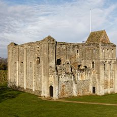
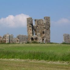
Castle Rising Castle, Medieval castle in Castle Rising, England
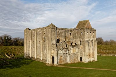
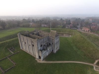
Castle Rising Castle is a Norman fortification with a large stone keep surrounded by extensive earthworks and three defensive rings. The complex spans several hectares and showcases structures built from local materials dating from the 12th century.
The castle was built shortly after 1100 by William d'Aubigny II, one of the most powerful barons of his time. In the 14th century it became a residence for Queen Isabella, demonstrating its importance in medieval hierarchies.
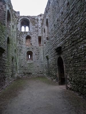
The castle displays Norman building elements, including a chapel from the 12th century and Romanesque decorative details with pilaster divisions throughout. These features remain visible on the walls and entrances of the keep.
The site is walkable across the earthworks and offers open views of the complex's layout. Visitors should be prepared for uneven ground and dress for the weather, as there is little shelter available.
The castle minted coins for Stephen during the 12th-century English civil war, underscoring its economic and political power. This rare coin production shows the status and resources the site commanded during turbulent times.
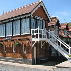
Location: Castle Rising
Inception: 1138
Founders: William d'Aubigny, 1st Earl of Arundel
Architectural style: Norman architecture
Website: http://castlerising.co.uk
GPS coordinates: 52.79294,0.46896
Latest update: December 7, 2025 20:47
St Mary Magdalene Church, Sandringham
4.8 km
Roydon Common
3.1 km
Mintlyn
4.9 km
Church of All Saints
2.6 km
Ruins of castle and eleventh century church
16 m
Church of St Andrew, Congham
4.8 km
Church of St Mary
3.1 km
Church of St Peter and St Paul
4.3 km
Church of St Peter
3.7 km
Church of All Saints
3.5 km
Church of St Lawrence
306 m
Sandringham War Memorial
4.9 km
Wolferton Station Downside
4 km
Wolferton Station Signal Box
4 km
Lamp Post At Tf 6660 2473 Circa 50 Metres North West Of Barn At Castle Farm
191 m
St James' church
3.9 km
K6 Telephone Kiosk At Tf 6663 2475
195 m
South Wootton War Memorial
3.1 km
Trinity Hospital (hospital Of The Holy And Undivided Trinity) And Attached Enclosing Walls, Circa 30 Metres East Of Church Of St
321 m
Barns At Castle Farm Circa 150 Metres South Of Church Of St Laurence
159 m
Market Cross
297 m
Lamp Post At Tf 6666 2473 Circa 20 Metres North Of Barn At Castle Farm
198 m
20 And 21, Low Road
400 m
St Felix's Church, Babingley
1.5 km
Butler's Cross
2.1 km
Milestone, 50yds E of roundabout
4.5 km
Milestone, Wootton Road, by No. 203 , 5yds N of Gaywood River
4.2 km
Milestone, roadside at TF6758228356
3.9 kmVisited this place? Tap the stars to rate it and share your experience / photos with the community! Try now! You can cancel it anytime.
Discover hidden gems everywhere you go!
From secret cafés to breathtaking viewpoints, skip the crowded tourist spots and find places that match your style. Our app makes it easy with voice search, smart filtering, route optimization, and insider tips from travelers worldwide. Download now for the complete mobile experience.
A unique approach to discovering new places❞
— Le Figaro
All the places worth exploring❞
— France Info
A tailor-made excursion in just a few clicks❞
— 20 Minutes