Enable Location

We need your location to show you interesting places around you

Discover nearby places

Find interesting locations and hidden gems around you

Precise directions

Get accurate directions and distances to places

Your location is never shared with other users. It's only used when you tap the location button.

Roydon Common

Log in to your account

Start exploring — it's free

Trusted by 61,848 travelers worldwide

Continue with Google
Continue with Apple
or

We will send you a code to connect

By continuing, you accept our Terms and Conditions and our Privacy Policy

Check your inbox

We've sent a pincode in your inbox. Please enter the code below.

Roydon Common

Roydon Common, Nature reserve in Norfolk, England.

Description

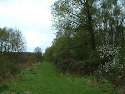
Roydon Common is a protected nature reserve in Norfolk covering about 360 hectares with different habitat types including heathland, acid bog, wet woodland, and grassland. These varied landscapes create homes for many different animal and plant species throughout the site.

History

A section called Grimston Warren was originally planted with pine trees but was later restored back to natural heathland. This restoration created new habitats for species that depend on open heath environments.

Culture

Norfolk Wildlife Trust maintains this site as part of the Gaywood Valley Living Landscape program, protecting natural environments across the region.

Practical

The site has several walking paths and a main parking area where visitors can enter for free. It is open from sunrise to sunset throughout the year.

Did you know?

This is the only place in East Anglia where you can see the raft spider in its natural habitat. The species is found in wet bog areas and makes the visit special for nature watchers.

Location
GPS coordinates
52.77300,0.50100
Latest update
December 14, 2025 18:14

AroundUs brings together thousands of curated places, local tips, and hidden gems, enriched daily by 60,000 contributors worldwide. Discover all places nearby (Norfolk).

Around this place
Castle Rising Castle
United Kingdom

Castle Rising Castle

3.1 km
Mintlyn
United Kingdom

Mintlyn

4.3 km
Ruins of castle and eleventh century church
United Kingdom

Ruins of castle and eleventh century church

3.1 km
Church of St Andrew, Congham
United Kingdom

Church of St Andrew, Congham

2.8 km
Church of St Mary
United Kingdom

Church of St Mary

4.8 km
Church of St Mary
United Kingdom

Church of St Mary

4.5 km
Church of All Saints
United Kingdom

Church of All Saints

1.7 km
Church of All Saints
United Kingdom

Church of All Saints

3.7 km
Church of St Lawrence
United Kingdom

Church of St Lawrence

3.3 km
Church of St Botolph
United Kingdom

Church of St Botolph

3.4 km
Hillington War Memorial
United Kingdom

Hillington War Memorial

4.5 km
Lamp Post At Tf 6660 2473 Circa 50 Metres North West Of Barn At Castle Farm
United Kingdom

Lamp Post At Tf 6660 2473 Circa 50 Metres North West Of Barn At Castle Farm

3.2 km
Ashwicken, Bawsey and Leziate War Memorial
United Kingdom

Ashwicken, Bawsey and Leziate War Memorial

3.7 km
K6 Telephone Kiosk At Tf 6663 2475
United Kingdom

K6 Telephone Kiosk At Tf 6663 2475

3.2 km
St Michael's church
United Kingdom

St Michael's church

4.4 km
South Wootton War Memorial
United Kingdom

South Wootton War Memorial

4.8 km
St James' church
United Kingdom

St James' church

3.1 km
Grimston War Memorial
United Kingdom

Grimston War Memorial

3.4 km
Butler's Cross
United Kingdom

Butler's Cross

4.2 km
20 And 21, Low Road
United Kingdom

20 And 21, Low Road

3.4 km
Lamp Post At Tf 6666 2473 Circa 20 Metres North Of Barn At Castle Farm
United Kingdom

Lamp Post At Tf 6666 2473 Circa 20 Metres North Of Barn At Castle Farm

3.2 km
Market Cross
United Kingdom

Market Cross

3.3 km
Trinity Hospital (hospital Of The Holy And Undivided Trinity) And Attached Enclosing Walls, Circa 30 Metres East Of Church Of St
United Kingdom

Trinity Hospital (hospital Of The Holy And Undivided Trinity) And Attached Enclosing Walls, Circa 30 Metres East Of Church Of St

3.2 km
Barns At Castle Farm Circa 150 Metres South Of Church Of St Laurence
United Kingdom

Barns At Castle Farm Circa 150 Metres South Of Church Of St Laurence

3.1 km
St Felix's Church, Babingley
United Kingdom

St Felix's Church, Babingley

4.3 km
Milestone, 50yds E of roundabout
United Kingdom

Milestone, 50yds E of roundabout

4 km
Milestone, Wootton Road, by No. 203 , 5yds N of Gaywood River
United Kingdom

Milestone, Wootton Road, by No. 203 , 5yds N of Gaywood River

5.1 km
Milestone, Outside 8 Fakenham Rd
United Kingdom

Milestone, Outside 8 Fakenham Rd

4.1 km
Show the full map
« Roydon Common - Nature reserve in Norfolk, England » is provided by Around Us (aroundus.com). Images and texts are derived from Wikimedia project under a Creative Commons license. You are allowed to copy, distribute, and modify copies of this page, under the conditions set by the license, as long as this note is clearly visible.

Discover hidden gems everywhere you go!

From secret cafés to breathtaking viewpoints, skip the crowded tourist spots and find places that match your style. Our app makes it easy with voice search, smart filtering, route optimization, and insider tips from travelers worldwide. Download now for the complete mobile experience.

Around Us App Screenshot

A unique approach to discovering new places

Le Figaro

All the places worth exploring

France Info

A tailor-made excursion in just a few clicks

20 Minutes

Around Us
Travel Guide & Maps
Download

Send to your phone

QR Code
1

Open the camera app on your mobile.

2

Point at the QR code with your camera. A notification will appear.

3

Tap the notification to open the link.