Chysauster Ancient Village

Log in to your account

AroundUs is a community-driven map of interesting places, built by curious explorers like you. It grows with every review, story, and photo you share.
Connect to save your favorite spots, contribute locations, and create personalized routes.
By continuing, you accept our Terms and Conditions and our Privacy Policy
Add to collection
Map
Suggest a change
Share

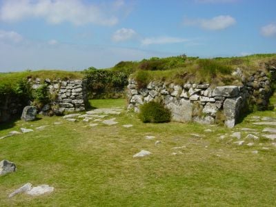
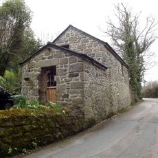
Chysauster Ancient Village, Iron Age settlement ruins in New Mill, England

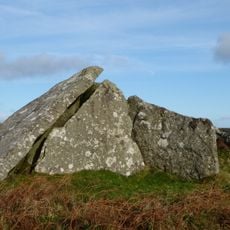
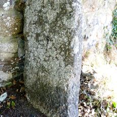
Chysauster is an Iron Age settlement with eight stone-built houses arranged along a central street. Each dwelling has an open central courtyard and multiple rooms that reveal how residents lived nearly 2000 years ago.

The settlement began in the first century BCE and remained occupied for about 200 years during the Romano-British period in Cornwall. The site reflects a time when Iron Age communities blended traditional ways of living with new influences from southern Europe.

The residents farmed the surrounding fields and raised livestock to feed their families and maintain their community. The arrangement of homes around a central pathway shows how people organized their daily life together in one settlement.

The site welcomes visitors without advance booking and offers free access to explore the ruins. Wear sturdy shoes as the ground is uneven and the location sits in open countryside.

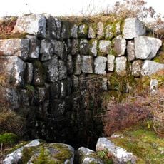
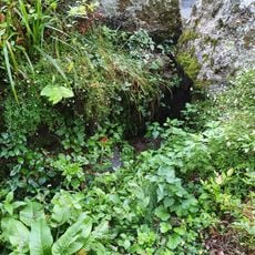
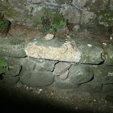
The village contains an underground passage system called a fogou, whose true purpose remains debated among researchers. Scholars suggest it may have served for food storage, ritual practices, or protection during troubled times.

Location: Madron

Inception: 100 BCE

Website: https://english-heritage.org.uk/visit/places/chysauster-ancient-village

GPS coordinates: 50.16110,-5.53966

Latest update: December 9, 2025 18:44

Photos
Around this place
Ding Dong mines
United Kingdom

Ding Dong mines

3.2 km
Zennor Quoit
United Kingdom

Zennor Quoit

3 km
Mulfra Quoit
United Kingdom

Mulfra Quoit

2.1 km
Madron Parish Church
United Kingdom

Madron Parish Church

3.7 km
Baker's Pit Nature Reserve
United Kingdom

Baker's Pit Nature Reserve

814 m
Treneere Manor
United Kingdom

Treneere Manor

3.8 km
Church of St Gulval
United Kingdom

Church of St Gulval

3.5 km
St Thomas
United Kingdom

St Thomas

3.7 km
Church of Saint Towennac
United Kingdom

Church of Saint Towennac

3.4 km
Newmill Bridge
United Kingdom

Newmill Bridge

1.8 km
Lych Gate And Mounting Block South West Of Church Of St Maddern
United Kingdom

Lych Gate And Mounting Block South West Of Church Of St Maddern

3.8 km
Coombe Cottage
United Kingdom

Coombe Cottage

3.7 km
Guide Post At Sw 451341
United Kingdom

Guide Post At Sw 451341

2.3 km
Holy well called Madron Well
United Kingdom

Holy well called Madron Well

3.5 km
Guide Post At Sw 452 380
United Kingdom

Guide Post At Sw 452 380

3.7 km
Boswarthen Cross
United Kingdom

Boswarthen Cross

3.7 km
Churchyard Walls And Entrance Stile On South Side Of Church Of Saint Towennac
United Kingdom

Churchyard Walls And Entrance Stile On South Side Of Church Of Saint Towennac

3.4 km
Madron Chapel
United Kingdom

Madron Chapel

3.4 km
Entrance grave known as Zennor Quoit 600m north-east of Foage Farm
United Kingdom

Entrance grave known as Zennor Quoit 600m north-east of Foage Farm

3 km
Wayside cross in Madron churchyard
United Kingdom

Wayside cross in Madron churchyard

3.8 km
Trereife Vault North East Of Church Of St Maddern
United Kingdom

Trereife Vault North East Of Church Of St Maddern

3.7 km
Rows Chest Tomb At Approximately 1 Metre West Of South Aisle Of Church Of St Paul
United Kingdom

Rows Chest Tomb At Approximately 1 Metre West Of South Aisle Of Church Of St Paul

3.8 km
2 Headstones At Approximately 8 Metres West Of Church Of St Paul
United Kingdom

2 Headstones At Approximately 8 Metres West Of Church Of St Paul

3.8 km
Milestone At Sw 494347
United Kingdom

Milestone At Sw 494347

2.1 km
Engine House And Associated Buildings At Sw 500372
United Kingdom

Engine House And Associated Buildings At Sw 500372

3.5 km
Group Of 2 Headstones And 2 Footstones At 1 Metre North Of Church Of Saint Towennac
United Kingdom

Group Of 2 Headstones And 2 Footstones At 1 Metre North Of Church Of Saint Towennac

3.4 km
Guidestone, Gear Hill, jct with Tannack Road, Newhill turn
United Kingdom

Guidestone, Gear Hill, jct with Tannack Road, Newhill turn

3.3 km
Guidestone, Green Lane Hill, T jct with Polmennor Road, opp. Gulval village sign
United Kingdom

Guidestone, Green Lane Hill, T jct with Polmennor Road, opp. Gulval village sign

3.5 km
Show the full map
Reviews

Visited this place? Tap the stars to rate it and share your experience / photos with the community! Try now! You can cancel it anytime.

« Chysauster Ancient Village - Iron Age settlement ruins in New Mill, England » is provided by Around Us (aroundus.com). Images and texts are derived from Wikimedia project under a Creative Commons license. You are allowed to copy, distribute, and modify copies of this page, under the conditions set by the license, as long as this note is clearly visible.

Discover hidden gems everywhere you go!

From secret cafés to breathtaking viewpoints, skip the crowded tourist spots and find places that match your style. Our app makes it easy with voice search, smart filtering, route optimization, and insider tips from travelers worldwide. Download now for the complete mobile experience.

Around Us App Screenshot

A unique approach to discovering new places

Le Figaro

All the places worth exploring

France Info

A tailor-made excursion in just a few clicks

20 Minutes