Sandal Castle, Medieval castle in Sandal Magna, England
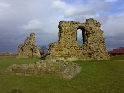
Sandal Castle is a medieval fortress in Wakefield built on a mound overlooking the River Calder, featuring remaining stone walls and earthwork fortifications that display Gothic military design. The site showcases the typical layout of a motte-and-bailey castle with defensive structures still visible across the grounds.
The fortress was founded in the 11th century and became a significant stronghold during the Wars of the Roses, particularly around the pivotal Battle of Wakefield in 1460. It suffered deliberate damage when soldiers dismantled its defenses in the mid-17th century.
The castle serves as a focal point for understanding the region's medieval past and draws visitors interested in exploring how fortifications shaped local life. Its position overlooking the river remains central to how people experience the landscape today.
The site is open to the public year-round with parking available and informational panels throughout the grounds. Wear sturdy footwear since the terrain is uneven and can become slippery during wet conditions.
During archaeological digs from 1964 to 1973, workers uncovered a medieval French ring bearing the message 'I am all yours', now housed in Wakefield Museum. This intimate object offers a window into the personal lives of people who once lived within these walls.
Location: Wakefield
Architectural style: Gothic architecture
Website: https://wakefield.gov.uk/museums-and-castles/sandal-castle
GPS coordinates: 53.65870,-1.49063
Latest update: December 7, 2025 10:03
Hepworth Wakefield
1.9 km
Chantry Chapel of St Mary the Virgin, Wakefield
2 km
Wakefield Castle
1.9 km
Kettlethorpe Hall
1.5 km
Thornes Park
2 km
Church of St James
1.7 km
Church of St Helen, Sandal
597 m
The Wakefield Arms
2.2 km
Bridge over Ings Beck
2.3 km
Dame Mary Bolle's Water Tower Including Water Wheel Housing And Overflow Channel
2.3 km
Wheelhouse Restaurant
2.4 km
Glad Tidings Hall
2.5 km
Little Bridge
1.9 km
Zion United Reformed Church and lodge to north east
2.5 km
Entrance block to Kirkgate Station
2.2 km
Chantry Bridge Wakefield
2 km
Urban Studies Centre
2.3 km
Office of Hebburn Conveyor Company
2.1 km
Heath House
2.6 km
Ninety-Nine Arches Viaduct
1.7 km
Navigation Warehouse
1.7 km
Sandal Vicarage
560 m
62, George Street
2.5 km
Stable Building To North Of Number 17
417 m
Rutland Mill
1.8 km
11–23, George Street
2.5 km
Milestone, Denby Dale Road, bridge over Ings Beck
2.3 km
Gate Piers And Gates To West Of Church Of St Helen
543 mVisited this place? Tap the stars to rate it and share your experience / photos with the community! Try now! You can cancel it anytime.
Discover hidden gems everywhere you go!
From secret cafés to breathtaking viewpoints, skip the crowded tourist spots and find places that match your style. Our app makes it easy with voice search, smart filtering, route optimization, and insider tips from travelers worldwide. Download now for the complete mobile experience.
A unique approach to discovering new places❞
— Le Figaro
All the places worth exploring❞
— France Info
A tailor-made excursion in just a few clicks❞
— 20 Minutes