Enable Location

We need your location to show you interesting places around you

Discover nearby places

Find interesting locations and hidden gems around you

Precise directions

Get accurate directions and distances to places

Your location is never shared with other users. It's only used when you tap the location button.

Low Force

Log in to your account

Start exploring — it's free

Trusted by 62,479 travelers worldwide

Continue with Google
Continue with Apple
or

We will send you a code to connect

By continuing, you accept our Terms and Conditions and our Privacy Policy

Check your inbox

We've sent a pincode in your inbox. Please enter the code below.

Low Force

Low Force, Waterfall in Holwick, County Durham, United Kingdom.

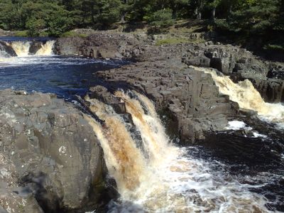
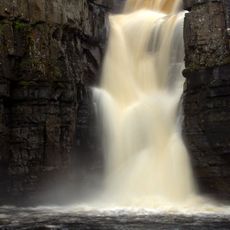
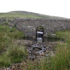
Low Force presents a series of cascades flowing through a gorge carved into layers of hard dolerite rock called Whin Sill, which formed nearly 300 million years ago from cooled underground molten rock.

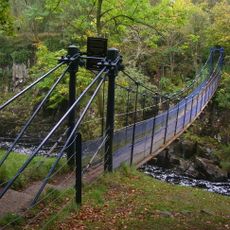
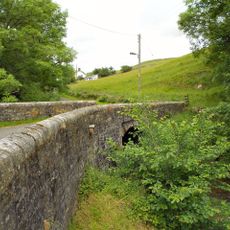
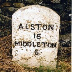
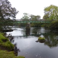
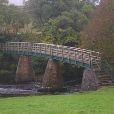
The waterfall is crossed by Wynch Bridge, built in 1741 as England's first chained suspension bridge, initially constructed for miners traveling to the Middleton lead mines in the area.

Low Force gained recognition as a filming location for Netflix's series 'The Witcher' in its second season, featuring scenes where characters Yennefer and Ciri attempt to cross the river.

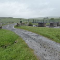
Visitors can reach the waterfall by car with free parking available at nearby lay-bys and the Bowlees Visitor Centre, requiring a 5-10 minute walk through woodland paths.

The waterfall measures approximately 18 feet in height but creates a dynamic spectacle through its series of stepped falls cascading over the ancient Whin Sill formation.

The community of curious travelers

AroundUs brings together thousands of curated places, local tips, and hidden gems, enriched daily by 60,000 contributors worldwide.

Start exploring
Location
Location
Part of
River Tees
GPS coordinates
54.64627,-2.15112
Latest update
July 25, 2025 19:46
Around this place
High Force
United Kingdom

High Force

2.4 km
Wynch Bridge
United Kingdom

Wynch Bridge

41 m
Cronkley Bridge
United Kingdom

Cronkley Bridge

4.4 km
3 Lee Tombs To South West Of Church Of St Mary
United Kingdom

3 Lee Tombs To South West Of Church Of St Mary

5 km
Church of St Mary
United Kingdom

Church of St Mary

5 km
The Teesdale Hotel
United Kingdom

The Teesdale Hotel

5 km
Marl Beck Mine Shop And Level
United Kingdom

Marl Beck Mine Shop And Level

4.7 km
Bridge Over Newbiggin Beck 100 Metres North Of Fellowship Farm
United Kingdom

Bridge Over Newbiggin Beck 100 Metres North Of Fellowship Farm

1.1 km
Milestone At Hanging Shaw
United Kingdom

Milestone At Hanging Shaw

4.1 km
Bleagill Bridge
United Kingdom

Bleagill Bridge

2.1 km
Middleton House
United Kingdom

Middleton House

4.7 km
Window Tracery Set In Graveyard, Circa 8 Metres South Of Gateway
United Kingdom

Window Tracery Set In Graveyard, Circa 8 Metres South Of Gateway

4.9 km
Milestone Circa 100 Metres West Of Brockersgill Sike
United Kingdom

Milestone Circa 100 Metres West Of Brockersgill Sike

1.8 km
Former Explosives Store At South Side Of Track
United Kingdom

Former Explosives Store At South Side Of Track

3.9 km
Holwick Head Bridge
United Kingdom

Holwick Head Bridge

1.5 km
55, Market Place
United Kingdom

55, Market Place

4.9 km
42-44, Market Place
United Kingdom

42-44, Market Place

5 km
49 And 50, Market Place
United Kingdom

49 And 50, Market Place

4.9 km
Market Cross
United Kingdom

Market Cross

4.9 km
Stable 4 Metres East Of Mine Shop
United Kingdom

Stable 4 Metres East Of Mine Shop

4 km
Milestone 100 Metres West Of Ettersgill Bridge
United Kingdom

Milestone 100 Metres West Of Ettersgill Bridge

1.1 km
9 And 10, Market Place
United Kingdom

9 And 10, Market Place

5 km
Middleton Working Men's Club
United Kingdom

Middleton Working Men's Club

4.8 km
Mill House  The Mill
United Kingdom

Mill House The Mill

4.9 km
Clock Tower, Weighbridge And Stables Adjoining
United Kingdom

Clock Tower, Weighbridge And Stables Adjoining

4.7 km
Coldberry lead mine and associated hushes
United Kingdom

Coldberry lead mine and associated hushes

3.2 km
Prehistoric settlements and cairnfield, medieval farmsteads, bloomeries and charcoal pits, 840m south of Cronkley on Bracken Rig
United Kingdom

Prehistoric settlements and cairnfield, medieval farmsteads, bloomeries and charcoal pits, 840m south of Cronkley on Bracken Rig

3.8 km
Scoberry Bridge
United Kingdom

Scoberry Bridge

886 m
Show the full map
« Low Force - Waterfall in Holwick, County Durham, United Kingdom » is provided by Around Us (aroundus.com). Images and texts are derived from Wikimedia project under a Creative Commons license. You are allowed to copy, distribute, and modify copies of this page, under the conditions set by the license, as long as this note is clearly visible.

Discover hidden gems everywhere you go!

From secret cafés to breathtaking viewpoints, skip the crowded tourist spots and find places that match your style. Our app makes it easy with voice search, smart filtering, route optimization, and insider tips from travelers worldwide. Download now for the complete mobile experience.

Around Us App Screenshot

A unique approach to discovering new places

Le Figaro

All the places worth exploring

France Info

A tailor-made excursion in just a few clicks

20 Minutes

Around Us
Travel Guide & Maps
Download

Send to your phone

QR Code
1

Open the camera app on your mobile.

2

Point at the QR code with your camera. A notification will appear.

3

Tap the notification to open the link.