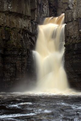
High Force, Waterfall in County Durham, England
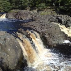
High Force is a waterfall in County Durham that drops in two stages over a vertical cliff, creating a powerful cascade on the River Tees. The water falls with force and generates mist and spray that can be felt from the viewing areas nearby.
This waterfall formed where the River Tees crosses the Whin Sill, a layer of igneous rock created approximately 295 million years ago. The hard rock creates the conditions for the water to drop steeply and form the dramatic cascade.
The painter J.M.W. Turner visited this waterfall in 1816 to sketch the landscape, and agricultural writer Arthur Young recorded his impressions of the site in 1771.
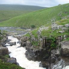
The northern bank access involves a fee through the Raby estate, while the southern bank offers free entry via the Pennine Way footpath. Wear sturdy shoes and watch your footing on wet or icy paths, as the ground can be slippery after rain or frost.
During winter months, the waterfall freezes into cathedral-like ice formations, transforming the cascading water into temporary natural sculptures. These ice structures form only under specific weather conditions and represent a rare and fleeting natural display.
Location: Forest and Frith
Location: Holwick
Part of: River Tees
GPS coordinates: 54.65030,-2.18765
Latest update: December 6, 2025 22:09
Cauldron Snout
6.5 km
Low Force
2.4 km
Upper Teesdale
6.3 km
Wynch Bridge
2.4 km
Cronkley Bridge
2 km
Milestone At Hanging Shaw
2 km
Bridge Over Newbiggin Beck 100 Metres North Of Fellowship Farm
3.5 km
Marl Beck Mine Shop And Level
7 km
Former Explosives Store At South Side Of Track
6.1 km
Holwick Head Bridge
913 m
Middleton House
7 km
Bleagill Bridge
3.5 km
Window Tracery Set In Graveyard, Circa 8 Metres South Of Gateway
7.3 km
Milestone Circa 100 Metres West Of Brockersgill Sike
4.2 km
55, Market Place
7.2 km
49 And 50, Market Place
7.3 km
Middleton Working Men's Club
7.2 km
Stable 4 Metres East Of Mine Shop
6.2 km
Milestone 100 Metres West Of Ettersgill Bridge
1.4 km
Coldberry lead mine and associated hushes
5.4 km
Mill House The Mill
7.2 km
Market Cross
7.2 km
Milestone 200 Metres South Of Redwing Plantation
5 km
Clock Tower, Weighbridge And Stables Adjoining
7.1 km
Prehistoric settlements and cairnfield, medieval farmsteads, bloomeries and charcoal pits, 840m south of Cronkley on Bracken Rig
1.5 km
Scoberry Bridge
3.2 km
Milestone, exNR, SW of Hargill Bridge
7.1 km
Birkdale footbridge
6.6 kmReviews
Visited this place? Tap the stars to rate it and share your experience / photos with the community! Try now! You can cancel it anytime.
Discover hidden gems everywhere you go!
From secret cafés to breathtaking viewpoints, skip the crowded tourist spots and find places that match your style. Our app makes it easy with voice search, smart filtering, route optimization, and insider tips from travelers worldwide. Download now for the complete mobile experience.
A unique approach to discovering new places❞
— Le Figaro
All the places worth exploring❞
— France Info
A tailor-made excursion in just a few clicks❞
— 20 Minutes