Cauldron Snout

Log in to your account

AroundUs is a community-driven map of interesting places, built by curious explorers like you. It grows with every review, story, and photo you share.
Connect to save your favorite spots, contribute locations, and create personalized routes.
Continue with Google
Continue with Apple
Continue with X
Continue with Facebook
Continue with email
By continuing, you accept our Terms and Conditions and our Privacy Policy
Create an account

Cauldron Snout

Add to collection
Map
Suggest a change
Share

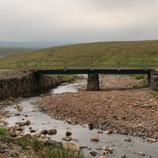
Cauldron Snout, Cascading waterfall in County Durham, England

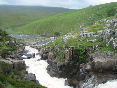
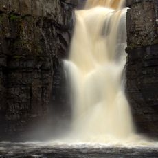
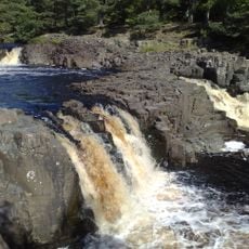
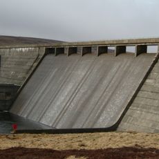
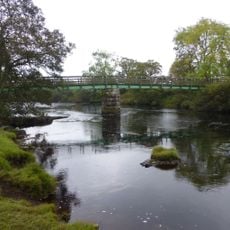
Cauldron Snout is a waterfall in the North Pennines where the River Tees cascades over stepped dolerite rock formations. The water drops across several hundred meters, creating a dramatic flow of falling water over the hard stone.

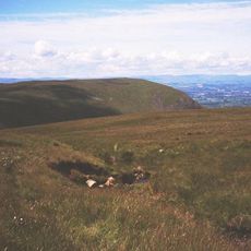
The rock formation over which the water falls is part of the ancient Whin Sill, a volcanic structure that shaped the landscape millions of years ago. This natural feature has defined the North Pennines terrain since prehistoric times.

The poet W.H. Auden referenced this waterfall in his 1941 work, connecting it to personal memories of the Weardale region. Literary references like this show how the place has captured the imagination of writers over the decades.

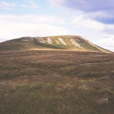
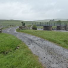
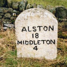
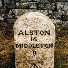
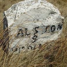
You will need to walk from the Cow Green Reservoir car park along trails to reach the waterfall viewing areas. Sturdy footwear and weatherproof clothing are essential since the terrain is hilly and often exposed to wind.

The water flowing down to create the waterfall comes from Cow Green Reservoir upstream, which means the flow changes depending on how the reservoir is managed. This makes each visit different, as the amount of water and the force of the cascade can vary from day to day.

Location: Forest and Frith

Location: Dufton

Part of: River Tees

GPS coordinates: 54.65257,-2.28908

Latest update: December 8, 2025 19:54

Photos
Around this place
High Force
United Kingdom

High Force

6.5 km
Mickle Fell
United Kingdom

Mickle Fell

4.2 km
Low Force
United Kingdom

Low Force

8.9 km
Cow Green Reservoir
United Kingdom

Cow Green Reservoir

2.1 km
Burnhope Seat
United Kingdom

Burnhope Seat

9.4 km
Upper Teesdale
United Kingdom

Upper Teesdale

3.7 km
Moorhouse and Cross Fell
United Kingdom

Moorhouse and Cross Fell

9.4 km
Appleby Fells
United Kingdom

Appleby Fells

6.5 km
Wynch Bridge
United Kingdom

Wynch Bridge

9 km
Cronkley Bridge
United Kingdom

Cronkley Bridge

4.8 km
Milestone At Hanging Shaw
United Kingdom

Milestone At Hanging Shaw

5.4 km
Holwick Head Bridge
United Kingdom

Holwick Head Bridge

7.5 km
5 Boundary Stones On Border With Cumbria
United Kingdom

5 Boundary Stones On Border With Cumbria

8.6 km
Milepost, 15 Metres North Of Grains O'Th'Beck Bridge
United Kingdom

Milepost, 15 Metres North Of Grains O'Th'Beck Bridge

9.5 km
Boundary Stone Next To Fence Circa 30 Feet From Road
United Kingdom

Boundary Stone Next To Fence Circa 30 Feet From Road

8.9 km
Milestone 200 Metres East Of Wad Hazel Sike
United Kingdom

Milestone 200 Metres East Of Wad Hazel Sike

6.8 km
Milestone To North Of Deadmangill Bridge
United Kingdom

Milestone To North Of Deadmangill Bridge

9.2 km
Prehistoric settlements and cairnfield, medieval farmsteads, bloomeries and charcoal pits, 840m south of Cronkley on Bracken Rig
United Kingdom

Prehistoric settlements and cairnfield, medieval farmsteads, bloomeries and charcoal pits, 840m south of Cronkley on Bracken Rig

5.1 km
Milestone 120 Metres South Of Trough Sike
United Kingdom

Milestone 120 Metres South Of Trough Sike

5.5 km
Milestone 100 Metres West Of Ettersgill Bridge
United Kingdom

Milestone 100 Metres West Of Ettersgill Bridge

7.9 km
Milestone 200 Metres South Of Redwing Plantation
United Kingdom

Milestone 200 Metres South Of Redwing Plantation

4.4 km
Moor House Bridge
United Kingdom

Moor House Bridge

7.5 km
Milestone 120 Metres East Of Near Crookburn Sike
United Kingdom

Milestone 120 Metres East Of Near Crookburn Sike

7.3 km
Milestone Half Way Between Darngill And Crookburn Bridges
United Kingdom

Milestone Half Way Between Darngill And Crookburn Bridges

8.7 km
Scoberry Bridge
United Kingdom

Scoberry Bridge

9.7 km
Birkdale footbridge
United Kingdom

Birkdale footbridge

122 m
Milestone, Helbeck Fell, 30m N of Blackmoorgate
United Kingdom

Milestone, Helbeck Fell, 30m N of Blackmoorgate

9.3 km
Milestone, exNR, east of Cumbria/Durham boundary signs
United Kingdom

Milestone, exNR, east of Cumbria/Durham boundary signs

8.9 km
Show the full map
Reviews

Visited this place? Tap the stars to rate it and share your experience / photos with the community! Try now! You can cancel it anytime.

« Cauldron Snout - Cascading waterfall in County Durham, England » is provided by Around Us (aroundus.com). Images and texts are derived from Wikimedia project under a Creative Commons license. You are allowed to copy, distribute, and modify copies of this page, under the conditions set by the license, as long as this note is clearly visible.

Discover hidden gems everywhere you go!

From secret cafés to breathtaking viewpoints, skip the crowded tourist spots and find places that match your style. Our app makes it easy with voice search, smart filtering, route optimization, and insider tips from travelers worldwide. Download now for the complete mobile experience.

Around Us App Screenshot

A unique approach to discovering new places

Le Figaro

All the places worth exploring

France Info

A tailor-made excursion in just a few clicks

20 Minutes