M4 motorway, Motorway from London to South Wales, United Kingdom
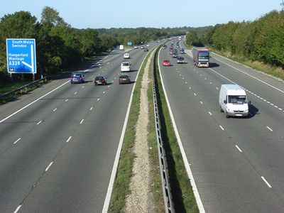
The M4 motorway is a controlled-access highway stretching approximately 190 miles from west London across southern England into South Wales, passing through or near several major urban areas. The route crosses varied terrain and intersects with many other trunk roads, with sections operating as a smart motorway featuring digital overhead signs and variable lane controls.
Construction started in the early 1960s with initial sections west of London. The route grew westward in stages over several decades until the final gap was closed in the mid-1990s.
This motorway functions as a primary transportation link between England and Wales, supporting economic growth and industrial development across multiple regions.
Electronic overhead signs display current speed limits and warnings, with some sections temporarily opening the hard shoulder as an extra lane during busy periods. Service areas and fuel stations appear at regular intervals, though some stretches cover longer distances without an exit.
One stretch near Swindon features five consecutive motorway junctions in close succession, creating an unusual concentration of connections. Two of the largest interchanges use four-level stack designs where carriageways loop above and below each other in multiple layers.
The community of curious travelers
AroundUs brings together thousands of curated places, local tips, and hidden gems, enriched daily by 60,000 contributors worldwide.