Mên-an-Tol

Log in to your account

AroundUs is a community-driven map of interesting places, built by curious explorers like you. It grows with every review, story, and photo you share.
Connect to save your favorite spots, contribute locations, and create personalized routes.
Continue with Google
Continue with Apple
Continue with X
Continue with Facebook
Continue with email
By continuing, you accept our Terms and Conditions and our Privacy Policy
Create an account
Add to collection
Map
Suggest a change
Share

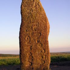
Mên-an-Tol, Stone circle in Cornwall, United Kingdom

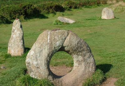
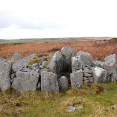
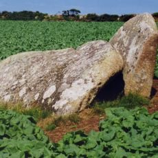
Mên-an-Tol is a group of three granite stones arranged in a line that forms a stone circle near Madron in Cornwall. The central stone carries a large circular hole and is flanked by two upright stones, all resting on open moorland.

The monument likely dates from the late Neolithic or early Bronze Age around 3,500 years ago. It may once have formed part of a larger circle whose remaining stones have since disappeared.

Local tradition held that crawling through the circular opening could cure conditions such as rickets and back ailments. Parents once passed sick children through the hole three times, while adults climbed through themselves.

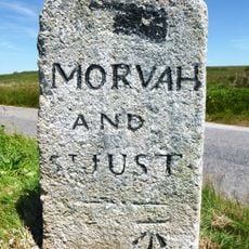
A footpath leads from the nearest parking area across the moorland directly to the stones. The site lies northwest of Penzance and remains freely accessible throughout the year.

The central stone is one of only two holed stones found in Cornwall, with a perfectly round opening measuring around half a meter across. The exact purpose of this opening remains unexplained to this day.

Location: Madron

GPS coordinates: 50.15856,-5.60450

Latest update: December 22, 2025 15:12

Photos
Stone circles: England, Scotland, Ireland, Germany and across Europe & USA

Stone circles stand among humanity's earliest architectural accomplishments, constructed by prehistoric communities across Europe and beyond over thousands of years. These circular arrangements of standing stones served multiple purposes, functioning as astronomical observatories where ancient...

Hidden locations in Cornwall

Cornwall holds scattered coves, historic manors, and ancient stone circles that together create a collection of places reflecting the region's history, culture, and landscape. Visitors can discover medieval castles like Tintagel Castle, climb lighthouses, explore underground caves, and walk through...

Around this place
Lanyon Quoit
United Kingdom

Lanyon Quoit

1.3 km
Boskednan stone circle
United Kingdom

Boskednan stone circle

800 m
Ding Dong mines
United Kingdom

Ding Dong mines

1.5 km
Mên Scryfa
United Kingdom

Mên Scryfa

355 m
Bosiliack Barrow
United Kingdom

Bosiliack Barrow

861 m
West Lanyon Quoit
United Kingdom

West Lanyon Quoit

1.2 km
United Kingdom

Methodist Chapel And Schoolroom And Front Courtyard Wall

1.3 km
Milestone At Sw 41682 34555, 110M North-East Of Bosullow
United Kingdom

Milestone At Sw 41682 34555, 110M North-East Of Bosullow

1 km
Lanyon Farmhouse, Front Garden Walls, Cartshed And Mounting Block
United Kingdom

Lanyon Farmhouse, Front Garden Walls, Cartshed And Mounting Block

861 m
United Kingdom

Round 340m south east of Trevean

1.4 km
United Kingdom

Hut circles with associated field system 400yds (360m) SW of Little Higher Bosullow

561 m
United Kingdom

Two hut circles 380yds (350m) NE of Trevean

1.5 km
United Kingdom

Courtyard house settlement and field system and medieval farmstead 440m south of Bosporthennis Farm Cottage

1.5 km
United Kingdom

Courtyard house and stone hut circle settlement 430m south west of Bosporthennis Farm Cottage

1.5 km
United Kingdom

Platform cairn 190m SSE of the Nine Maidens Stone Circle

853 m
United Kingdom

Round barrow 300yds (270m) W of Nine Maidens

531 m
United Kingdom

Old Bosiliack Farmhouse

1.3 km
United Kingdom

Standing stone 60m north west of the Nine Maidens Stone Circle

772 m
United Kingdom

Enclosure 220yds (200m) NE of Trevean

1.5 km
United Kingdom

Two round barrows 300yds (270m) E of Little Higher Bosullow

131 m
Guidepost Approximately 350M North-West Of Bosullow Cottage
United Kingdom

Guidepost Approximately 350M North-West Of Bosullow Cottage

1.2 km
United Kingdom

Three round barrows 650yds (595m) N of Nine Maidens stone circle

1.1 km
United Kingdom

Round barrow 600yds (550m) NW of Nine Maidens stone circle

678 m
United Kingdom

Round barrow 1000yds (910m) ESE of Rosemergy SW of Carn Galver

984 m
United Kingdom

Deserted medieval settlement with 16th and 18th century structures 85m west of West Lanyon Quoit

1.2 km
United Kingdom

Kerbed cairn and round cairn 210m north west of the Nine Maidens Stone Circle

716 m
United Kingdom

Engine House At Sw 434346, Greenburrow Mine

955 m
United Kingdom

Bosiliack prehistoric settlement, field systems, entrance grave, cairns and later tinworks

634 m
Show the full map
Reviews

Visited this place? Tap the stars to rate it and share your experience / photos with the community! Try now! You can cancel it anytime.

« Mên-an-Tol - Stone circle in Cornwall, United Kingdom » is provided by Around Us (aroundus.com). Images and texts are derived from Wikimedia project under a Creative Commons license. You are allowed to copy, distribute, and modify copies of this page, under the conditions set by the license, as long as this note is clearly visible.

Discover hidden gems everywhere you go!

From secret cafés to breathtaking viewpoints, skip the crowded tourist spots and find places that match your style. Our app makes it easy with voice search, smart filtering, route optimization, and insider tips from travelers worldwide. Download now for the complete mobile experience.

Around Us App Screenshot

A unique approach to discovering new places

Le Figaro

All the places worth exploring

France Info

A tailor-made excursion in just a few clicks

20 Minutes