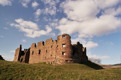
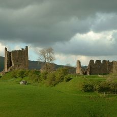
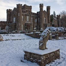
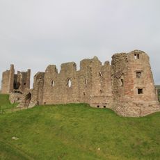
Brough Castle, Medieval castle in Brough, England
Brough Castle is a stone fortress in England featuring a square tower, defensive wall remnants, and gateway structures positioned on a ridge overlooking Stainmore Pass. The layout clearly shows how medieval architecture was designed for both protection and daily living.
William II of England built the original wooden castle in 1092 on the foundations of the Roman fort Verterae to secure the Pennine route. The structure was repeatedly rebuilt and reinforced over time because of its location on an important trade route.
The castle served as a significant residence for noble families and played a central role in the surrounding region's social life. The buildings reflect the changes in how people lived and organized themselves in this border area over the centuries.
The site is in open countryside and can be viewed from outside, so visitors should check locally for current opening arrangements and access details. The castle is accessible in all weather conditions, so wear weatherproof clothing and sturdy footwear for uneven ground.
Lady Anne Clifford directed major renovations between 1659 and 1661, leaving architectural elements still visible in today's ruins. Her efforts show how individuals attempted to preserve important places even as decline continued in the decades that followed.
Location: Brough
Inception: 1092
Founders: William II of England
Architects: Anne Clifford
Part of: Brough Castle and Brough (Verterae) Roman fort and civil settlement
Website: https://english-heritage.org.uk/visit/places/brough-castle
GPS coordinates: 54.52181,-2.32348
Latest update: December 8, 2025 19:41
Verterae
583 m
Church of St Michael
238 m
Castle Hotel And Inn
636 m
Post Office/Shop
602 m
House Adjoining North End Of Castle Hotel
633 m
Augill Castle
1.5 km
Bridge House, Opposite Ford Bridge
238 m
Harglade
674 m
Clock Tower On Traffic Island At Junction With Market Street
609 m
Brough Castle and Brough (Verterae) Roman fort and civil settlement
68 m
Former Market Cross To North Of Crossleigh
682 m
One-Stop Shop
599 m
Maypole On Former Cross Base
250 m
Cross Base To South Of St Michael's Church
261 m
Boundary Stone To North Of Bullistone Cottage
963 m
Helbeck Hall With Retaining Wall To Rear
1.7 km
Grove House
620 m
Milestone To South-East Of Swindale Cottages
939 m
Bank House
636 m
Burneside House
608 m
Boundary Stone To North-West Of Duck Pool Farm
1.2 km
Glaslyn House
632 m
Wiend House And Adjoining Store
180 m
Oddfellows Hall
592 m
Building Between One-Stop Shop And Post Office
598 m
House Adjoining South End Of Hazel Bank Cottage
579 m
Guidestone, Swindale Grange
1.4 km
2 Grove Cottages
627 mVisited this place? Tap the stars to rate it and share your experience / photos with the community! Try now! You can cancel it anytime.
Discover hidden gems everywhere you go!
From secret cafés to breathtaking viewpoints, skip the crowded tourist spots and find places that match your style. Our app makes it easy with voice search, smart filtering, route optimization, and insider tips from travelers worldwide. Download now for the complete mobile experience.
A unique approach to discovering new places❞
— Le Figaro
All the places worth exploring❞
— France Info
A tailor-made excursion in just a few clicks❞
— 20 Minutes