Slickstones Quarry, Cromhall

Log in to your account

AroundUs is a community-driven map of interesting places, built by curious explorers like you. It grows with every review, story, and photo you share.
Connect to save your favorite spots, contribute locations, and create personalized routes.
Continue with Google
Continue with Apple
Continue with X
Continue with Facebook
Continue with email
By continuing, you accept our Terms and Conditions and our Privacy Policy
Create an account
Add to collection
Map
Suggest a change
Share

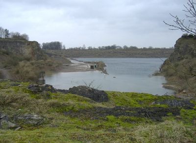
Slickstones Quarry, Cromhall, Paleontological site in Cromhall, England.

Slickstones Quarry is a quarry with a large lake featuring rock formations from the Carboniferous period, approximately 350 million years old. The limestone and oolite layers expose sedimentary rocks that were once part of a shallow marine environment, now revealing fossils of ancient creatures preserved within the stone.

The quarry was officially designated as a protected scientific site in 1966 due to its geological and paleontological importance to researchers. This recognition ensured the preservation of its rock layers and fossil deposits, allowing continued study of the ancient life forms they contain.

The site draws scientists and geology enthusiasts who recognize its importance as a window into prehistoric life and the evolution of species over millions of years. Visitors who explore the exposed rock layers can see firsthand how different organisms inhabited this region long ago.

The site is actively used for diving instruction and water safety training, which means access to certain areas may be restricted or controlled. Visitors should check conditions beforehand to understand which parts of the quarry are open for viewing and where activities take place.

Among the numerous fossils found here is Agnosphitys cromhallensis, a small early reptile about 2 feet long that fed on insects. This creature ranks among the earliest known members of its lineage and demonstrates the variety of life that existed during this ancient period.

Location: Cromhall

GPS coordinates: 51.62240,-2.42897

Latest update: December 14, 2025 18:10

Photos
Around this place
Tortworth Court
United Kingdom

Tortworth Court

1.4 km
Kingswood Abbey
United Kingdom

Kingswood Abbey

4.3 km
St James' Church, Charfield
United Kingdom

St James' Church, Charfield

1.6 km
Parish Church of the Holy Trinity
United Kingdom

Parish Church of the Holy Trinity

3.3 km
Church of All Saints
United Kingdom

Church of All Saints

4.3 km
Church of St George
United Kingdom

Church of St George

2.7 km
Parish Church of St John
United Kingdom

Parish Church of St John

1.7 km
Parish Church of St Andrew
United Kingdom

Parish Church of St Andrew

1.6 km
Parish Church of St Leonard
United Kingdom

Parish Church of St Leonard

1.7 km
Swan Inn
United Kingdom

Swan Inn

4.8 km
Church of St James
United Kingdom

Church of St James

4.8 km
Canopied Seat And Flanking Walls,Memorial To The Countess Of Ducie,25 Yards East Of Chancel Of St Leonard's Church
United Kingdom

Canopied Seat And Flanking Walls,Memorial To The Countess Of Ducie,25 Yards East Of Chancel Of St Leonard's Church

1.7 km
Sturt Bridge, Wickwar
United Kingdom

Sturt Bridge, Wickwar

4.4 km
Charfield War Memorial
United Kingdom

Charfield War Memorial

1.7 km
The Round House
United Kingdom

The Round House

4 km
Tytherington War Memorial
United Kingdom

Tytherington War Memorial

4.8 km
Frith Farmhouse,and Bakehouse At South East
United Kingdom

Frith Farmhouse,and Bakehouse At South East

4.5 km
Former Mill Building At New Mills,west Of Bushford Bridge
United Kingdom

Former Mill Building At New Mills,west Of Bushford Bridge

3.6 km
Boundary House,Including Gatepiers And Wall
United Kingdom

Boundary House,Including Gatepiers And Wall

4.2 km
Milestone At National Grid Reference St6977 8999
United Kingdom

Milestone At National Grid Reference St6977 8999

1.7 km
Milestone At National Grid Reference St 6928 8850
United Kingdom

Milestone At National Grid Reference St 6928 8850

3.3 km
Abbey Gatehouse And Adjoining Wall To East
United Kingdom

Abbey Gatehouse And Adjoining Wall To East

4.3 km
Milestone At National Grid Reference St 6904 8704
United Kingdom

Milestone At National Grid Reference St 6904 8704

4.8 km
Milestone, just W jcn minor road to N Nibley
United Kingdom

Milestone, just W jcn minor road to N Nibley

3.9 km
Milestone, Gloucester Road, 100m East of Morton Farm
United Kingdom

Milestone, Gloucester Road, 100m East of Morton Farm

4.2 km
Milestone, Gloucester Road, Morton
United Kingdom

Milestone, Gloucester Road, Morton

3.5 km
Milestone, Woodford
United Kingdom

Milestone, Woodford

4.7 km
Milestone, Milbury Heath; 130m N Cutts Heath Road
United Kingdom

Milestone, Milbury Heath; 130m N Cutts Heath Road

4.4 km
Show the full map
Reviews

Visited this place? Tap the stars to rate it and share your experience / photos with the community! Try now! You can cancel it anytime.

« Slickstones Quarry, Cromhall - Paleontological site in Cromhall, England » is provided by Around Us (aroundus.com). Images and texts are derived from Wikimedia project under a Creative Commons license. You are allowed to copy, distribute, and modify copies of this page, under the conditions set by the license, as long as this note is clearly visible.

Discover hidden gems everywhere you go!

From secret cafés to breathtaking viewpoints, skip the crowded tourist spots and find places that match your style. Our app makes it easy with voice search, smart filtering, route optimization, and insider tips from travelers worldwide. Download now for the complete mobile experience.

Around Us App Screenshot

A unique approach to discovering new places

Le Figaro

All the places worth exploring

France Info

A tailor-made excursion in just a few clicks

20 Minutes