Tappoch Broch

Log in to your account

AroundUs is a community-driven map of interesting places, built by curious explorers like you. It grows with every review, story, and photo you share.
Connect to save your favorite spots, contribute locations, and create personalized routes.
Continue with Google
Continue with Apple
Continue with X
Continue with Facebook
Continue with email
By continuing, you accept our Terms and Conditions and our Privacy Policy
Create an account
Add to collection
Map
Suggest a change
Share

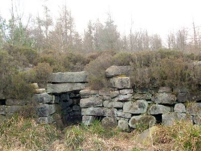
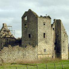
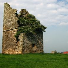
Tappoch Broch, Iron Age broch in Torwood, Scotland

Tappoch Broch is a circular Iron Age stone structure in Scotland with thick walls measuring between 5 and 7.5 meters that enclose an oval inner chamber roughly 10 meters across. An entrance passage on the southeast side leads inward through the walls for several meters, giving access to the central space.

This structure was built during the Iron Age and served as a fortified dwelling for a local community. An excavation in the 1800s uncovered the original ground level and revealed important details about how the building was constructed and used.

This was a gathering place in Iron Age times where people made tools, prepared food, and lived together as a community. The pottery and grain-grinding stones found here show how daily life unfolded within these ancient walls.

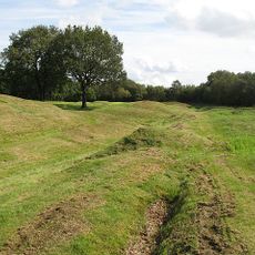
The site sits on open ground with uneven surfaces that need careful footing when exploring around the ruins. Good walking shoes and attention to weather conditions are wise, as the exposed terrain can become muddy and slippery in wet conditions.

The structure contains evidence of a well-designed internal staircase with sloped inner walls that points to an original roof built using stones that cantilevered inward. This construction method shows the builders possessed sophisticated engineering skills for their era.

Location: Falkirk

Location: Dunipace

Website: http://falkirklocalhistorysociety.co.uk/home/index.php?id=144

GPS coordinates: 56.04349,-3.87435

Latest update: December 12, 2025 14:23

Photos
Around this place
Falkirk Wheel
United Kingdom

Falkirk Wheel

5.2 km
Ochilview Park
United Kingdom

Ochilview Park

4.1 km
Rough Castle Fort
United Kingdom

Rough Castle Fort

5.2 km
Torwood Castle
United Kingdom

Torwood Castle

668 m
Bannockburn House
United Kingdom

Bannockburn House

4.6 km
Plean Castle
United Kingdom

Plean Castle

2.6 km
Denny Town House
United Kingdom

Denny Town House

3.5 km
St Mary of the Angels, Camelon
United Kingdom

St Mary of the Angels, Camelon

5.4 km
Larbert Old Church, Churchyard With James Bruce Monument
United Kingdom

Larbert Old Church, Churchyard With James Bruce Monument

3.5 km
Cinema De Luxe
United Kingdom

Cinema De Luxe

3.2 km
Larbert Viaduct
United Kingdom

Larbert Viaduct

4 km
Stenhousemuir, Kirk Avenue, Larbert East Church And Hall
United Kingdom

Stenhousemuir, Kirk Avenue, Larbert East Church And Hall

4.2 km
Larbert Old Church
United Kingdom

Larbert Old Church

3.6 km
Plean House
United Kingdom

Plean House

1.7 km
Bannockburn House, Old Dovecot
United Kingdom

Bannockburn House, Old Dovecot

4.6 km
Main Office Building, Carron Ironworks, Stenhouse Road, Larbert
United Kingdom

Main Office Building, Carron Ironworks, Stenhouse Road, Larbert

5.5 km
Larbert, Main Street, Dobbie Hall
United Kingdom

Larbert, Main Street, Dobbie Hall

3.7 km
Old Bridge, Larbert
United Kingdom

Old Bridge, Larbert

4.1 km
Bainsford, Carron River, Carron Railway Bridge
United Kingdom

Bainsford, Carron River, Carron Railway Bridge

5.4 km
Antonine Wall, 495m WSW and 125m SE of Bonnyside House
United Kingdom

Antonine Wall, 495m WSW and 125m SE of Bonnyside House

5.2 km
Dunipace Bridge
United Kingdom

Dunipace Bridge

3.3 km
Larbert bridge
United Kingdom

Larbert bridge

4.1 km
Larbert, Main Street, Larbert Station, War Memorial
United Kingdom

Larbert, Main Street, Larbert Station, War Memorial

3.6 km
Grahamston Ironworks, Falkirk
United Kingdom

Grahamston Ironworks, Falkirk

5.3 km
Carron, River Carron, Weir
United Kingdom

Carron, River Carron, Weir

5.3 km
Stenhousemuir, Carrongrange Avenue, Carrongrange
United Kingdom

Stenhousemuir, Carrongrange Avenue, Carrongrange

4.8 km
Lodge, Royal Scottish National Hospital, Bellsdyke Road, Larbert
United Kingdom

Lodge, Royal Scottish National Hospital, Bellsdyke Road, Larbert

2.9 km
Stenhousemuir, 86 Burnhead Road, Falkirk Tryst Golf Course, War Memorial
United Kingdom

Stenhousemuir, 86 Burnhead Road, Falkirk Tryst Golf Course, War Memorial

3.5 km
Show the full map
Reviews

Visited this place? Tap the stars to rate it and share your experience / photos with the community! Try now! You can cancel it anytime.

« Tappoch Broch - Iron Age broch in Torwood, Scotland » is provided by Around Us (aroundus.com). Images and texts are derived from Wikimedia project under a Creative Commons license. You are allowed to copy, distribute, and modify copies of this page, under the conditions set by the license, as long as this note is clearly visible.

Discover hidden gems everywhere you go!

From secret cafés to breathtaking viewpoints, skip the crowded tourist spots and find places that match your style. Our app makes it easy with voice search, smart filtering, route optimization, and insider tips from travelers worldwide. Download now for the complete mobile experience.

Around Us App Screenshot

A unique approach to discovering new places

Le Figaro

All the places worth exploring

France Info

A tailor-made excursion in just a few clicks

20 Minutes