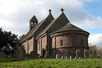
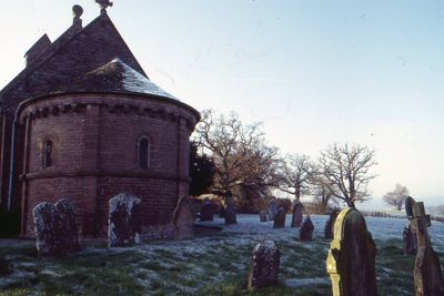
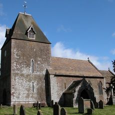
Church of St Mary and St David, Kilpeck, Romanesque church in Kilpeck, England.
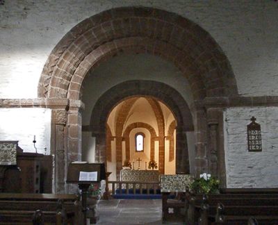
The Church of St Mary and St David is a Norman building with rounded arches, thick stone walls, and decorative arcading on both the exterior and interior. The structure displays typical Romanesque features with elaborate details that shape both the outside and inside.
The building dates to 1101 and represents early Norman influence on medieval architecture in England. This period marked the beginning of a new architectural tradition that would shape English church design.
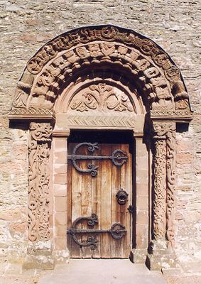
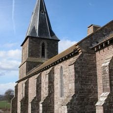
The red sandstone carvings on the south side display medieval craftsmanship with detailed patterns and figures shaped by skilled artisans of that era. The carved corbels and doorway frame tell stories through their carefully sculpted forms.
The building is open during daylight hours and can be visited from sunrise to sunset without restrictions. Parking spaces are available near the entrance, making arrival straightforward.
A remarkable Sheela Na Gig carving depicting a female figure adorns the outer wall alongside other red sandstone sculptures. This depiction is uncommon in English churches and catches the attention of visitors exploring the building's facade.
Location: Kilpeck
Inception: 12 century
Architectural style: Romanesque architecture
Website: http://kilpeckchurch.org.uk
GPS coordinates: 51.97030,-2.80920
Latest update: December 8, 2025 19:52
The Mynde
2.7 km
Kilpeck Castle
12 m
Church of St Dubricius, at St Devereux, Herefordshire
830 m
Church of St David
3.8 km
Church of St Peter and St Thomas
1.8 km
Milestone At So 449322
1.7 km
William Price Memorial approximately 2 meters south of chancel of Church of St Mary and St David
13 m
Cottage about 90 yards south of The Mynde
2.7 km
Much Dewchurch War Memorial
3.6 km
The Priory Farmhouse
332 m
Barn about 50 yards south-west of Newhouse Farmhouse
1.4 km
Didley Court Farmhouse
1.6 km
K6 Telephone Kiosk
156 m
Outbuilding attached to north west of The Mynde
2.6 km
Ha ha about 30 yards to east of The Mynde
2.8 km
Newhouse Farmhouse and enclosing walls to north-west
1.3 km
Milestone, Howton Farm
3.4 km
Stables and outbuildings attached to south-west of The Mynde
2.7 km
Kilpeck Court Farmhouse
56 m
Kitchen garden walls to north of The Mynde
2.6 km
Garden walls to south of The Mynde
2.7 km
Churchyard cross in St David's churchyard
3.7 km
Barn approximately 30 meters north-east of Kilpeck Court Farmhouse
59 m
Milepost, Church View
4 km
Group of two adjoining barns approximately 50 meters west of Priory Farmhouse
304 m
Milepost, Top Hill
3 km
Milepost, Church View, The Rhydd (ruined property)
3.5 km
Milepost, Willox Bridge; E of A465 jcn
3.4 kmVisited this place? Tap the stars to rate it and share your experience / photos with the community! Try now! You can cancel it anytime.
Discover hidden gems everywhere you go!
From secret cafés to breathtaking viewpoints, skip the crowded tourist spots and find places that match your style. Our app makes it easy with voice search, smart filtering, route optimization, and insider tips from travelers worldwide. Download now for the complete mobile experience.
A unique approach to discovering new places❞
— Le Figaro
All the places worth exploring❞
— France Info
A tailor-made excursion in just a few clicks❞
— 20 Minutes