·

Enable Location

We need your location to show you interesting places around you

Discover nearby places

Find interesting locations and hidden gems around you

Precise directions

Get accurate directions and distances to places

Your location is never shared with other users. It's only used when you tap the location button.

Alban Way

Log in to your account

Start exploring — it's free

Trusted by 62,650 travelers worldwide

Continue with Google
Continue with Apple
or

We will send you a code to connect

By continuing, you accept our Terms and Conditions and our Privacy Policy

Check your inbox

We've sent a pincode in your inbox. Please enter the code below.

Alban Way

Alban Way, Radverkehrsanlage im Vereinigten Königreich

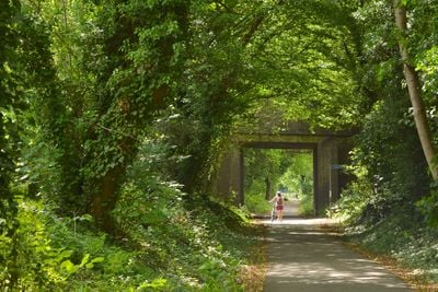
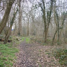
Alban Way is a bike and walking path in Hertfordshire that stretches approximately 6.5 miles along a former railway line connecting St Albans and Hatfield. The route features a smooth, flat surface suitable for all ages and runs through green countryside with fields and wooded sections.

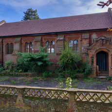
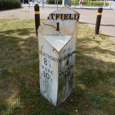
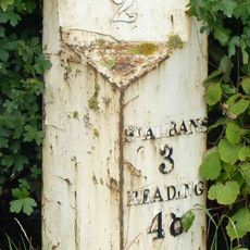
The route follows a railway line built in the early 20th century that was closed in the late 20th century. After closure, the line was converted into the current bike and walking path while preserving remnants of the old railway infrastructure such as former station platforms.

The path takes its name from the historic railway line it follows and serves as a daily gathering space where locals enjoy outdoor exercise and leisure time. Community events and organized rides happen along the route, bringing people together to experience the countryside.

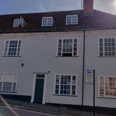
The path is accessible year-round with multiple entry points such as Highfield Park in St Albans and near Ellenbrook Lane in Hatfield. Wet weather can make the surface slippery, so check conditions before visiting and bring appropriate footwear or gear for the season.

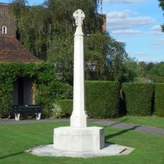
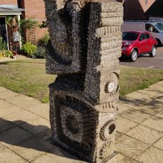
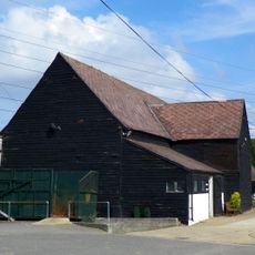
Public artworks commissioned as part of cultural projects line the route, adding visual interest and reflecting local history to create a welcoming environment. These installations give the path a distinctive character that goes beyond its function as a simple walking and cycling route.

The community of curious travelers

AroundUs brings together thousands of curated places, local tips, and hidden gems, enriched daily by 60,000 contributors worldwide.

Start exploring
Location
GPS coordinates
51.75200,-0.25900
Latest update
February 7, 2026 11:40
Around this place
Tyttenhanger House
United Kingdom

Tyttenhanger House

2.9 km
The Eight Bells, Hatfield
United Kingdom

The Eight Bells, Hatfield

3.4 km
Hatfield War Memorial
United Kingdom

Hatfield War Memorial

3.3 km
Statue of the Marquess of Salisbury
United Kingdom

Statue of the Marquess of Salisbury

3.3 km
Oxleys Wood
United Kingdom

Oxleys Wood

2.5 km
Church of St John the Evangelist
United Kingdom

Church of St John the Evangelist

1.8 km
The Plough Inn
United Kingdom

The Plough Inn

391 m
Church of St Luke
United Kingdom

Church of St Luke

2.8 km
Roman Catholic Church of Marychurch
United Kingdom

Roman Catholic Church of Marychurch

3.3 km
Church of St Mark
United Kingdom

Church of St Mark

1.3 km
8 and 10, Church Street
United Kingdom

8 and 10, Church Street

3.3 km
30, Church Street
United Kingdom

30, Church Street

3.3 km
Gates,Screen And 4 Gateposts To Hatfield Park
United Kingdom

Gates,Screen And 4 Gateposts To Hatfield Park

3.3 km
1,3 And 5, Park Street
United Kingdom

1,3 And 5, Park Street

3.3 km
5, Church Street
United Kingdom

5, Church Street

3.3 km
St Ethelreda's Church Hall
United Kingdom

St Ethelreda's Church Hall

3.4 km
24, Church Street
United Kingdom

24, Church Street

3.3 km
The Comet Public House
United Kingdom

The Comet Public House

1.4 km
Mural Located In Former Lee Valley Water Company Offices And Free-Standing Sculpture On West Side Of Entrance Drive
United Kingdom

Mural Located In Former Lee Valley Water Company Offices And Free-Standing Sculpture On West Side Of Entrance Drive

1.8 km
17, Fore Street
United Kingdom

17, Fore Street

3.4 km
Milepost On North Side Of Road, South Of Oaklands College
United Kingdom

Milepost On North Side Of Road, South Of Oaklands College

2 km
The Old Coach House
United Kingdom

The Old Coach House

3.3 km
Number 19 And Rear Barn
United Kingdom

Number 19 And Rear Barn

3.3 km
21,23 And 25, Fore Street
United Kingdom

21,23 And 25, Fore Street

3.3 km
Milepost To West Of Comet Roundabout, Opposite Comet Public House
United Kingdom

Milepost To West Of Comet Roundabout, Opposite Comet Public House

1.4 km
Milepost Approximately 70 Metres East North East Of The Three Horseshoes Public House
United Kingdom

Milepost Approximately 70 Metres East North East Of The Three Horseshoes Public House

661 m
Barn About 60 Metres North West Of Coursers Farm House
United Kingdom

Barn About 60 Metres North West Of Coursers Farm House

2.6 km
Signpost On Pavement In Front Of Number 2 (The Eight Bells Public House)
United Kingdom

Signpost On Pavement In Front Of Number 2 (The Eight Bells Public House)

3.3 km
Show the full map
« Alban Way - Radverkehrsanlage im Vereinigten Königreich » is provided by Around Us (aroundus.com). Images and texts are derived from Wikimedia project under a Creative Commons license. You are allowed to copy, distribute, and modify copies of this page, under the conditions set by the license, as long as this note is clearly visible.

Discover hidden gems everywhere you go!

From secret cafés to breathtaking viewpoints, skip the crowded tourist spots and find places that match your style. Our app makes it easy with voice search, smart filtering, route optimization, and insider tips from travelers worldwide. Download now for the complete mobile experience.

Around Us App Screenshot

A unique approach to discovering new places

Le Figaro

All the places worth exploring

France Info

A tailor-made excursion in just a few clicks

20 Minutes

Around Us
Travel Guide & Maps
Download

Send to your phone

QR Code
1

Open the camera app on your mobile.

2

Point at the QR code with your camera. A notification will appear.

3

Tap the notification to open the link.