Chest opened
+${chestReward.xp} XP
Explorer
NOUVEAU ×${chestReward.collectible.quantity}
tapez pour fermer
Chest locked

Open chests in the app

Around Us is built for your phone — chests unlock when you walk, explore and capture nearby places.

Enable Location

We need your location to show you interesting places around you

Discover nearby places

Find interesting locations and hidden gems around you

Precise directions

Get accurate directions and distances to places

Your location is never shared with other users. It's only used when you tap the location button.

Aberdeen Western Peripheral Route

Log in to your account

Start exploring — it's free

Trusted by 72,989 travelers worldwide

Continue with Google
Continue with Apple
or

We will send you a code to connect

By continuing, you accept our Terms and Conditions and our Privacy Policy

Check your inbox

We've sent a pincode in your inbox. Please enter the code below.

Aberdeen Western Peripheral Route
Discussion Reviews 1 Photos
16.8k Popularity

Aberdeen Western Peripheral Route, road in Scotland

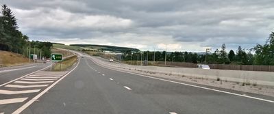
The Aberdeen Western Peripheral Route is a ring road that circles the city of Aberdeen in Scotland. It spans approximately 42 kilometers and links key areas like Stonehaven, Charleston, and Blackdog with modern junctions and nine major entry points.

The route was first proposed in 1952, but construction began in 2015 and finished in 2019. Building became necessary because the older Anderson Drive from the 1930s could not handle the city's growth after the Second World War.

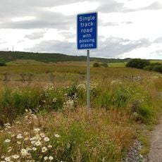
The route has nine junctions and grade-separated crossings, meaning vehicles can drive most of the way without traffic lights. Emergency lay-bys are available for breakdowns, and clear signage shows directions and destinations throughout.

The route was designed to keep heavy trucks off city streets, and it has successfully reduced the number of lorries traveling through Aberdeen. After opening, some areas needed improvements such as new traffic lights at the Cleanhill roundabout following accidents.

The community of curious travelers

AroundUs brings together thousands of curated places, local tips, and hidden gems, enriched daily by 60,000 contributors worldwide.

Start exploring
Location
Aberdeen City
GPS coordinates
57.13780,-2.24697
Latest update
February 17, 2026 01:41
Around this place
Brimmond Hill
United Kingdom

Brimmond Hill

3.9 km
St Peter's Parish Church
United Kingdom

St Peter's Parish Church

4.9 km
Culter House
United Kingdom

Culter House

4 km
Westhill Library
United Kingdom

Westhill Library

2.7 km
Cults Mill
United Kingdom

Cults Mill

5 km
Newhills Parish Church
United Kingdom

Newhills Parish Church

4.9 km
Newhills House
United Kingdom

Newhills House

4.7 km
Boundary Marker 40, Kirkhill Farm, Aberdeen,
United Kingdom

Boundary Marker 40, Kirkhill Farm, Aberdeen,

5 km
Boundary Marker 12, Craigton Road, Aberdeen,
United Kingdom

Boundary Marker 12, Craigton Road, Aberdeen,

4.4 km
Boundary Marker 31,  Wynford, Aberdeen,
United Kingdom

Boundary Marker 31, Wynford, Aberdeen,

4.3 km
Piper Alpha Memorial
United Kingdom

Piper Alpha Memorial

4.1 km
Davidson House
United Kingdom

Davidson House

4.6 km
Peterculter, 3 To 5 Howie Lane
United Kingdom

Peterculter, 3 To 5 Howie Lane

4.9 km
Boundary Marker 15,  Bailliewells Farm, Aberdeen
United Kingdom

Boundary Marker 15, Bailliewells Farm, Aberdeen

3.2 km
Kennerty Bridge
United Kingdom

Kennerty Bridge

4.9 km
Newhills, Old Parish Church, Burial-ground
United Kingdom

Newhills, Old Parish Church, Burial-ground

4.7 km
Boundary Marker 32, Tulloch, Aberdeen
United Kingdom

Boundary Marker 32, Tulloch, Aberdeen

4.7 km
Viaduct, South Approach, Woodend General Hospital, Aberdeen
United Kingdom

Viaduct, South Approach, Woodend General Hospital, Aberdeen

4.6 km
Main Building, Woodend General Hospital, Aberdeen
United Kingdom

Main Building, Woodend General Hospital, Aberdeen

4.7 km
Boundary Marker 37, East Wall, Steading, Ashtown, Aberdeen
United Kingdom

Boundary Marker 37, East Wall, Steading, Ashtown, Aberdeen

5 km
Boundary Marker 39, Ashtown, Aberdeen
United Kingdom

Boundary Marker 39, Ashtown, Aberdeen

4.9 km
Boundary Marker 38, Ashtown, Aberdeen
United Kingdom

Boundary Marker 38, Ashtown, Aberdeen

4.9 km
Boundary Marker 33, Tulloch, Aberdeen
United Kingdom

Boundary Marker 33, Tulloch, Aberdeen

4.8 km
Boundary Marker 11, Craigton Road, Aberdeen,
United Kingdom

Boundary Marker 11, Craigton Road, Aberdeen,

5 km
Boundary Marker 30, Wynford Farm, Aberdeen,
United Kingdom

Boundary Marker 30, Wynford Farm, Aberdeen,

4.1 km
Queen Mother Rose Garden
United Kingdom

Queen Mother Rose Garden

4 km
Kingswells, Consumption Dykes
United Kingdom

Kingswells, Consumption Dykes

2.1 km
Commemorative plaque to Nan Shepherd
United Kingdom

Commemorative plaque to Nan Shepherd

4.4 km
Show the full map
Reviews
Share your experience

No review yet

Discussions
Start a discussion...

No discussion yet

« Aberdeen Western Peripheral Route - road in Scotland » is provided by Around Us (aroundus.com). Images and texts are derived from Wikimedia project under a Creative Commons license. You are allowed to copy, distribute, and modify copies of this page, under the conditions set by the license, as long as this note is clearly visible.

Discover hidden gems everywhere you go!

From secret cafés to breathtaking viewpoints, skip the crowded tourist spots and find places that match your style. Our app makes it easy with voice search, smart filtering, route optimization, and insider tips from travelers worldwide. Download now for the complete mobile experience.

Around Us App Screenshot

A unique approach to discovering new places

Le Figaro

All the places worth exploring

France Info

A tailor-made excursion in just a few clicks

20 Minutes

Around Us
Travel Guide & Maps
Download

Send to your phone

QR Code
1

Open the camera app on your mobile.

2

Point at the QR code with your camera. A notification will appear.

3

Tap the notification to open the link.