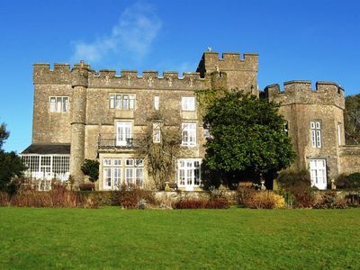
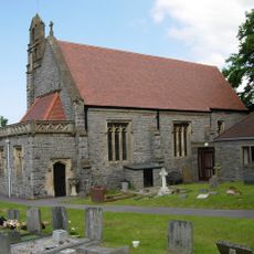
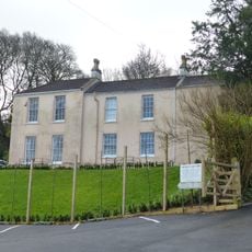
Banwell Castle, Gothic Revival castle in Banwell, England.
Banwell Castle is a Victorian mansion from the 1800s with five central windows flanked by two round towers and a terrace decorated with pierced parapet details. The entrance features lion statues on gate piers, and the entire property sits within 25 acres (10 hectares) of gardens and grounds.
This castle was built in 1847 for a London solicitor named John Dyer Sympson on land that had previously belonged to the Bishop of Bath and Wells. The site replaced an earlier structure that had stood there before.
The architecture shows the Gothic Revival style that was popular during the Victorian period, with round towers and decorative pierced parapets that you can see when you walk around the building. These design choices reflect what wealthy people liked to build in their homes during that era.
The site operates as a bed and breakfast with a restaurant, so you can stay overnight and dine on the grounds. It is best to book in advance if you plan to visit, and you can explore the gardens when you arrive.
During World War II, the Royal Air Force operated their Barrage Balloon Section headquarters from this Somerset property, making it a key site in the country's air defense efforts. Few visitors realize that this quiet country estate played such an important military role during the war.
Location: Banwell
Website: http://banwellcastle.co.uk
GPS coordinates: 51.32350,-2.85424
Latest update: December 8, 2025 21:01
Church of St James, Winscombe
2 km
Church of St Andrew, Banwell
810 m
Banwell Caves
2.3 km
Jubilee Clock Tower
4 km
Sidney Hill Cottage Homes
3.7 km
Churchill Methodist Church
3.9 km
Max Bog
1.2 km
Church of St Andrew, Compton Bishop
3.4 km
Banwell Camp
506 m
Church of St John the Baptist, Churchill
3.6 km
Church of St Mary, Christon
2.9 km
Church of All Saints
1.9 km
Church of St Leonard
3.9 km
The New Inn
4 km
Crook Peak
3.3 km
Sandford Station Railway Heritage Centre
1.4 km
Shipham War Memorial
4 km
Manor Farmhouse and attached barn
3.4 km
Old Vicarage
2.1 km
K6 Telephone Kiosk
3.7 km
Milestone At Ngr St 4356 5814
3 km
Main block with entrance elevation to Sidcot School
2.6 km
Nut Tree Farmhouse
1.5 km
Unknown chest tomb in churchyard, 9 metres south of chancel, Church of St Andrew
3.4 km
Medieval estate boundary earthwork on Shute Shelve Hill
3.4 km
Church cross, in churchyard, 10 metres south of Church of St Andrew
3.4 km
Sidcot Farmhouse
2.7 km
Milepost, near Winscombe & Sidcot, near entrance to Fullers Lane
2.6 kmVisited this place? Tap the stars to rate it and share your experience / photos with the community! Try now! You can cancel it anytime.
Discover hidden gems everywhere you go!
From secret cafés to breathtaking viewpoints, skip the crowded tourist spots and find places that match your style. Our app makes it easy with voice search, smart filtering, route optimization, and insider tips from travelers worldwide. Download now for the complete mobile experience.
A unique approach to discovering new places❞
— Le Figaro
All the places worth exploring❞
— France Info
A tailor-made excursion in just a few clicks❞
— 20 Minutes