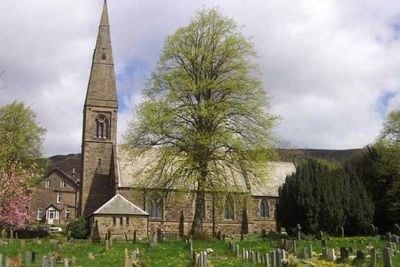
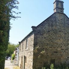
St John the Baptist church, Anglican church in Bamford, England
St John the Baptist church features local stone construction with characteristic elements of Victorian ecclesiastical design and structured interior spaces.
The construction of St John the Baptist church began in 1860 under the direction of architect William Butterfield during the Gothic Revival period.
The Grade II* listed building maintains religious services and functions as a central meeting point for local community gatherings throughout the year.
The church operates regular weekly services and remains accessible to visitors who wish to explore its architectural features and historical significance.
The church exemplifies William Butterfield's architectural style through its polychromatic brickwork patterns and specific structural compositions.
Location: Bamford
Inception: 1860
Architects: William Butterfield
GPS coordinates: 53.34687,-1.68960
Latest update: March 6, 2025 19:28
Navio Roman Fort
2.8 km
Church of St Michael and All Angels
3 km
Roman Catholic Church of Our Lady of Sorrows and Attached Presbytery
395 m
Roman Catholic Church of St Michael
2.8 km
North Lees Chapel
2.6 km
North Lees Hall
2.8 km
Hathersage Viaduct
2.9 km
Aston Hall
2.2 km
Navio Roman fort and vicus
2.7 km
Cross shaft in St Michael's churchyard
3.1 km
Yorkshire Bridge
1.9 km
Offerton Hall
2.4 km
Former Gamekeepers Lodge At Brookfield Manor
2.5 km
The Old Bell House
3.1 km
Camp Green ringwork
3.1 km
Milepost 20 Yards To The South West Of The Entrance To Hathersage Hall
3.1 km
Outbuilding To The North East Of The Old Bell House
3.1 km
Nether Hall
3 km
Rock House, Attached Outbuilding Entrance, Gate Piers And Gates
3.1 km
Lamp column to the north east of Hathersage Farmhouse
2.9 km
Dale Mill And Detached Chimney
3.2 km
Barns at North Lees Hall
2.8 km
Brookfield Manor
2.4 km
Rectory And Attached Coach House
48 m
Mile Post At Os 189 826
2 km
Prehistoric standing stone 1,030m south west of triangulation point on High Neb
1.8 km
Milestone, The Crofts, at jct with Main Road, opp service station, to left of public toilets
2.9 km
Milepost, Hope Road, Mytham, just W of Mytham Leadmill Bridge
883 mReviews
Visited this place? Tap the stars to rate it and share your experience / photos with the community! Try now! You can cancel it anytime.
Discover hidden gems everywhere you go!
From secret cafés to breathtaking viewpoints, skip the crowded tourist spots and find places that match your style. Our app makes it easy with voice search, smart filtering, route optimization, and insider tips from travelers worldwide. Download now for the complete mobile experience.
A unique approach to discovering new places❞
— Le Figaro
All the places worth exploring❞
— France Info
A tailor-made excursion in just a few clicks❞
— 20 Minutes