Barwick-in-Elmet Castle
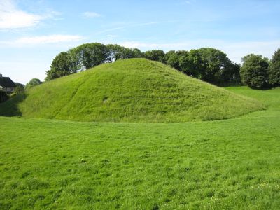
Barwick-in-Elmet Castle, Medieval motte-and-bailey fortification in Barwick in Elmet, England.
Barwick-in-Elmet Castle is a medieval motte-and-bailey fortification in Barwick in Elmet, consisting of two earthwork mounds surrounded by deep defensive ditches. The site displays the typical structure of Norman-era castles with raised earth ramparts and interconnected trenches.
Following the Norman Conquest, Ilbert de Lacy received these lands and constructed the fortification on top of an earlier Iron Age settlement. The structure served as an administrative stronghold for Norman control in the region during the medieval period.
The fortification represents the evolution of medieval military architecture, demonstrating the transition from basic defensive structures to administrative centers of Norman authority.
The remains are accessible via a path behind the Methodist church, with the motte rising approximately 15 meters above the surrounding ground. Visitors should expect uneven terrain and wear sturdy footwear for exploring the site.
During World War II, the Royal Observer Corps used the motte as an aircraft spotting post, and the concrete platform at the summit remains visible today. This unexpected military repurposing connects the site to a much later chapter in British defence history.
Location: Barwick in Elmet and Scholes
GPS coordinates: 53.83330,-1.39519
Latest update: December 9, 2025 20:27
Nellie's Tree
2.9 km
Becca Hall
2.3 km
Parish Church of St Ricarius Or St Riquier
3.4 km
Aberford Dykes
1.8 km
Church of All Saints
279 m
St. Peter's Church, Thorner
3.5 km
Crawshaw Woods (Shippen House Farm) Bridge, Hul4/20
3.6 km
Milepost Against Wall Of Garden To St Wilfrids Roman Catholic Church
3.6 km
Scholes Library
2.4 km
Gascoigne Almshouses And Attached Wardens Cottage
3.6 km
The Swan Hotel
3.4 km
Aberford Bridge
3.5 km
Barwick-in-Elmet War Memorial
180 m
The Rotunda In The Black Fen Pleasure Ground
3.5 km
Shelter At Approximately Se428368
2.9 km
Temple Of Leod Lud Approximately 300 Metres Due South Of The Rotunda In The Black Fen Pleasure Grounds
3.2 km
Mile Post At Se433381
3.5 km
Cross Base And Shaft Approximately 20 Metres North West Of Butts Garth House
3.3 km
Aberford House Including Front Garden Wall With Gatepiers And Inner Paved Parterre With Steps
3.5 km
Lodge To Gascoigne Almshouses
3.6 km
Milestone Opposite Junction With Kiddall Lane
2 km
Triumphal Arch
2.5 km
Milepost At Se415398
2.8 km
Pikes Head Lodge
3.2 km
Market Cross Beside South Gate To Church Of St Ricarius
3.5 km
West Wing, Potterton Hall
1.5 km
Obelisk And Enclosing Railings Approximately 200 Metres South East Of Rotunda In Black Fen Pleasure Grounds
3.4 km
The Dark Arch
2.9 kmVisited this place? Tap the stars to rate it and share your experience / photos with the community! Try now! You can cancel it anytime.
Discover hidden gems everywhere you go!
From secret cafés to breathtaking viewpoints, skip the crowded tourist spots and find places that match your style. Our app makes it easy with voice search, smart filtering, route optimization, and insider tips from travelers worldwide. Download now for the complete mobile experience.
A unique approach to discovering new places❞
— Le Figaro
All the places worth exploring❞
— France Info
A tailor-made excursion in just a few clicks❞
— 20 Minutes