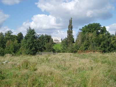
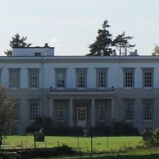
Buxted Park, Historic estate and natural conservation area in Buxted, England
Buxted Park is an 84-hectare estate in England with unimproved grassland, a Georgian mansion, and a large artificial lake. The property supports diverse plant and animal species, making it valuable for natural conservation.
The deer park dates to 1199, while the Georgian mansion was built in 1725 and underwent major restoration by architect Basil Ionides following a 1940 fire. This rebuilding restored the house to its current form.
The Royal Society of Arts moved its library collection to Buxted Park during World War II to protect valuable books and records.
The property operates as a country house hotel, so accommodation guests have the easiest access to the grounds and walking paths. Visitors planning a day visit should inquire in advance about access to different areas and trails.
The house incorporates architectural elements from other properties, including features salvaged from West Harling Hall and Chesterfield House in London. These salvaged pieces were integrated during restoration work, creating an unexpected architectural blend.
Location: Buxted
GPS coordinates: 51.00500,0.09800
Latest update: December 12, 2025 17:40
The Old Parish Church of St Margaret
2.3 km
The Baptist Church
3.1 km
St John the Evangelist Church, Heron's Ghyll
2.2 km
Five Ash Down Independent Chapel
1.3 km
Rock Wood
0 m
Copping Hall
3.5 km
The Parish Church of St Andrew and St Mary
4.6 km
The Parish Church of St Bartholomew
1.2 km
The Parish Church of the Holy Cross
3.5 km
Church of St Mary the Virgin
3 km
Holy Trinity Church
2.7 km
Buxted Park Hotel
2.5 km
The Maiden's Head Hotel
3.6 km
Hooke Hall
3.4 km
Chequers Hotel
1.1 km
Holmesdale Farmhouse
4.5 km
The Hogge House
2.1 km
The Almshouses
2 km
Courtyard With Terms, Balustrade And Fountain West Side Of Buxted Park
2.4 km
224 And 226, High Street
3.5 km
Uckfield War Memorial
3.5 km
Milepost, Forest Lodge Nursing Home, Cackle Street, jct of High Street with Huggets Lane
2.5 km
Milestone, by church at jct of High Street and Straight Halfmile
1.1 km
Milepost, High Street jct with Bell Lane, at traffic lights
3.9 km
Milepost, Camp Hill; 330m N track to Crows Nest
4.5 km
Milepost, High Street, Nutley, just N of jct with Nursery Lane
4 km
Milepost, Lampool roundabout, NE edge
1.2 km
Milepost, Ringles Cross PH, London Road
2.4 kmVisited this place? Tap the stars to rate it and share your experience / photos with the community! Try now! You can cancel it anytime.
Discover hidden gems everywhere you go!
From secret cafés to breathtaking viewpoints, skip the crowded tourist spots and find places that match your style. Our app makes it easy with voice search, smart filtering, route optimization, and insider tips from travelers worldwide. Download now for the complete mobile experience.
A unique approach to discovering new places❞
— Le Figaro
All the places worth exploring❞
— France Info
A tailor-made excursion in just a few clicks❞
— 20 Minutes