Bristol Road Methodist Church

Log in to your account

AroundUs is a community-driven map of interesting places, built by curious explorers like you. It grows with every review, story, and photo you share.
Connect to save your favorite spots, contribute locations, and create personalized routes.
Continue with Google
Continue with Apple
Continue with X
Continue with Facebook
Continue with email
By continuing, you accept our Terms and Conditions and our Privacy Policy
Create an account
Add to collection
Map
Suggest a change
Share

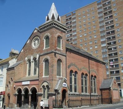
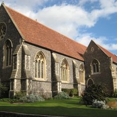
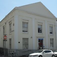
Bristol Road Methodist Church, Methodist church building in Brighton and Hove, England.

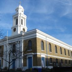
Bristol Road Methodist Church is a Methodist place of worship built from brown brick with decorative details and a distinctive corner tower topped by an octagonal spire. The structure showcases Romanesque Revival design through its polychrome accents and carefully detailed entrance porch with side stair turret.

The building was designed in 1873 by architect Thomas Lainson for the Methodist community in eastern Brighton. It served its congregation for over 100 years until services ended in 1989, after which the Grade II listing ensured its protection.

The building reflects the growth of Methodist congregations that established themselves across Brighton during the 1800s as part of a broader religious movement. You can see how the scale and quality of construction reveal the importance of this community to the neighborhood at that time.

The Grade II listed structure is easily visible from the street in a residential neighborhood and accessible to walk around for exterior viewing. Note that it no longer functions as an active place of worship, so visits are best suited to viewing the architecture from outside.

The structure includes an arcade-style entrance porch with a side stair turret, details that reveal the craftsmanship typical of the Romanesque Revival period. These features are often overlooked but add considerable character to the overall appearance.

Location: Brighton and Hove

Architectural style: Romanesque Revival architecture

GPS coordinates: 50.81963,-0.12455

Latest update: December 14, 2025 17:42

Photos
Around this place
Volk's Electric Railway
United Kingdom

Volk's Electric Railway

358 m
Royal Crescent
United Kingdom

Royal Crescent

136 m
Madeira Terrace And Madeira Walk And Lift Tower And Related Buildings
United Kingdom

Madeira Terrace And Madeira Walk And Lift Tower And Related Buildings

375 m
St George's Church, Brighton
United Kingdom

St George's Church, Brighton

402 m
St John the Baptist's Church, Brighton
United Kingdom

St John the Baptist's Church, Brighton

112 m
St Mary the Virgin, Brighton
United Kingdom

St Mary the Virgin, Brighton

353 m
Pelham Institute
United Kingdom

Pelham Institute

124 m
Brighton and Hove National Spiritualist Church
United Kingdom

Brighton and Hove National Spiritualist Church

560 m
Steve Ovett: Olympian
United Kingdom

Steve Ovett: Olympian

404 m
Brighton College Chapel
United Kingdom

Brighton College Chapel

237 m
Banjo Groyne On The Beach At The Bottom Of Paston Place
United Kingdom

Banjo Groyne On The Beach At The Bottom Of Paston Place

497 m
Royal Crescent Hotel And Attached Walls And Railings
United Kingdom

Royal Crescent Hotel And Attached Walls And Railings

155 m
The Colonnade
United Kingdom

The Colonnade

546 m
Old Fire Station
United Kingdom

Old Fire Station

286 m
Railings Running The Length Of Marine Parade
United Kingdom

Railings Running The Length Of Marine Parade

514 m
Classroom Dining Hall And Head Masters House Brighton College
United Kingdom

Classroom Dining Hall And Head Masters House Brighton College

280 m
Egremont Gate And Attached Wall And Railings
United Kingdom

Egremont Gate And Attached Wall And Railings

518 m
Bristol Court
United Kingdom

Bristol Court

429 m
Numbers 70 And 71 And 72 And Attached Piers And Railings
United Kingdom

Numbers 70 And 71 And 72 And Attached Piers And Railings

257 m
Park Street Gate And Attached Walls And Piers And Railings
United Kingdom

Park Street Gate And Attached Walls And Piers And Railings

429 m
The Royal Gymnasium And Attached Railings
United Kingdom

The Royal Gymnasium And Attached Railings

436 m
Pearson House
United Kingdom

Pearson House

311 m
Clock Tower 30 Metres West Of Number 15 East Drive (Number 15 East Drive Not Included)
United Kingdom

Clock Tower 30 Metres West Of Number 15 East Drive (Number 15 East Drive Not Included)

546 m
Number 37 And Attached Railings
United Kingdom

Number 37 And Attached Railings

557 m
St Josephs Convent Of Mercy
United Kingdom

St Josephs Convent Of Mercy

66 m
Numbers 1 To 9 And Attached Walls Piers And Railings
United Kingdom

Numbers 1 To 9 And Attached Walls Piers And Railings

486 m
Shelter Opposite Marine Square
United Kingdom

Shelter Opposite Marine Square

307 m
Numbers 38 And 39 And Attached Walls And Piers
United Kingdom

Numbers 38 And 39 And Attached Walls And Piers

492 m
Show the full map
Reviews

Visited this place? Tap the stars to rate it and share your experience / photos with the community! Try now! You can cancel it anytime.

« Bristol Road Methodist Church - Methodist church building in Brighton and Hove, England » is provided by Around Us (aroundus.com). Images and texts are derived from Wikimedia project under a Creative Commons license. You are allowed to copy, distribute, and modify copies of this page, under the conditions set by the license, as long as this note is clearly visible.

Discover hidden gems everywhere you go!

From secret cafés to breathtaking viewpoints, skip the crowded tourist spots and find places that match your style. Our app makes it easy with voice search, smart filtering, route optimization, and insider tips from travelers worldwide. Download now for the complete mobile experience.

Around Us App Screenshot

A unique approach to discovering new places

Le Figaro

All the places worth exploring

France Info

A tailor-made excursion in just a few clicks

20 Minutes