Castle Ring, Iron Age hillfort in Cannock Wood, England
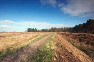
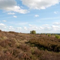
Castle Ring is a fortified hilltop settlement in Cannock Wood with multiple lines of earth ramparts and ditches running along its slopes. The structure uses the natural ridge to create defensive layers that once encircled the settlement at its crown.
The Cornovii tribe built this fortified settlement around 500 BCE as a defensive stronghold on the hill. Following the Roman invasion in 43 CE, the site lost its original military purpose and was eventually repurposed for different uses.
This hilltop served as a place of power and protection for different communities across many centuries. People used the high ground in turn for defense, hunting, and keeping watch over the surrounding land.
You can reach the site using walking paths that loop around the hill through Cannock Wood and clearly mark the ramparts. The ground can be muddy or slippery after rain, so sturdy footwear is worth bringing along.
The hilltop offered a vantage point from which residents could spot other defensive structures across the wider landscape. This line of sight to neighboring forts likely played a key role in choosing this particular location.
Location: Cannock Wood
Elevation above the sea: 242 m
GPS coordinates: 52.71320,-1.93600
Latest update: December 10, 2025 16:29
Chasewater Railway
4.2 km
Beaudesert
1.2 km
Farewell Priory
4.1 km
Hawkesyard Priory
4.1 km
Armitage Park
4.1 km
Our Lady of Lourdes Church, Hednesford
4.2 km
Gentleshaw Common
1.8 km
St Anne's Church
3.5 km
Church of St Michael
3.7 km
Church of St James
4 km
Armitage United Reform Church Chapel
4.7 km
Church of St Bartholomew
4.1 km
Christchurch
4.6 km
Cross Keys Inn
4.3 km
Christ Church
1.1 km
Chase Terrace and Boney Hay War Memorial
2.8 km
Anglesey Hotel
4.4 km
Brereton House
3.5 km
Heath Hayes War Memorial Gates
4 km
Hednesford War Memorial And Gates
4 km
Milepost, traffic island south of Brereton
3.4 km
Brereton War Memorial
3.5 km
Mile Stone (1 Mile From Rugeley)
4.5 km
Milepost, SE of Mossley, Rugeley
4.4 km
Morrisons
3.8 km
Milepost, St James' Close, Longdon Village
3.8 km
Milepost, between Armitage & Rugeley
4.2 km
Milepost, N of Rawnsley Road jct
3.9 kmVisited this place? Tap the stars to rate it and share your experience / photos with the community! Try now! You can cancel it anytime.
Discover hidden gems everywhere you go!
From secret cafés to breathtaking viewpoints, skip the crowded tourist spots and find places that match your style. Our app makes it easy with voice search, smart filtering, route optimization, and insider tips from travelers worldwide. Download now for the complete mobile experience.
A unique approach to discovering new places❞
— Le Figaro
All the places worth exploring❞
— France Info
A tailor-made excursion in just a few clicks❞
— 20 Minutes