Christ Church, Heaton Norris, Gothic Revival church building in Stockport, England.
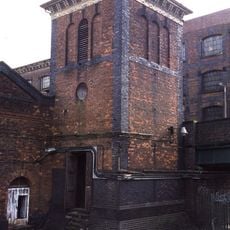
Christ Church in Heaton Norris is a Gothic Revival church built from yellow sandstone, standing on a hill along Wellington Road North. The structure features a four-stage tower topped by a tall spire, with paired lancet windows and decorative plate tracery across its facade.
The building was constructed in the mid-1800s as part of a wave of church construction in growing urban areas. A serious fire in 1977 severely damaged the structure and permanently altered its appearance.
The place was named for its religious purpose and shows typical Victorian design choices of its era. The remaining structures offer insight into how important this building was for the local community during the 1800s.
The building sits on a hilltop linking Stockport and Manchester areas, making it visible from the street. Visitors should be aware that the structure's condition may be affected by past fire damage.
The tower top includes openings that once held clock faces, along with delicate pierced decorations around its edge. These details showcase the skilled stonework of Victorian craftsmen who created such refined architectural features.
Location: Stockport
Inception: 1846
Architectural style: Gothic Revival
Website: http://visitchurches.org.uk/findachurch/christ-church-heaton-norris/?region=Manchester
GPS coordinates: 53.41440,-2.16780
Latest update: December 13, 2025 12:42
Hat Works
750 m
Stockport Air Raid Shelters
710 m
Underbank Hall
712 m
Wear Mill
628 m
Nursery Inn
608 m
Wycliffe Congregational Chapel
177 m
Bakers Vaults Public House
749 m
Wellington Bridge
681 m
Swan With Two Necks Public House
542 m
The Kings Arms Public House
732 m
The White Lion Hotel
701 m
52, Wellington Road North
215 m
Steps adjacent to former Plaza Cinema
722 m
19, Great Underbank
729 m
Wellington Mill
752 m
1 Great Underbank and 26 and 28 Bridge Street Brow
734 m
Pendlebury Hall
488 m
15-17, Bridge Street
683 m
Pair of K6 telephone kiosks
715 m
Engine house to former London and North Western Railway Goods Warehouse
119 m
30 and 32, Great Underbank
699 m
Former London and North Western Railway Goods Warehouse
67 m
13 and 15, Great Underbank
734 m
Portion of town wall to rear of Numbers 9 to 13 Town Wall
734 m
21 and 23, Great Underbank
732 m
223-245, Green Lane
699 m
213, Chestergate
682 m
16 and 18, Great Underbank
698 mVisited this place? Tap the stars to rate it and share your experience / photos with the community! Try now! You can cancel it anytime.
Discover hidden gems everywhere you go!
From secret cafés to breathtaking viewpoints, skip the crowded tourist spots and find places that match your style. Our app makes it easy with voice search, smart filtering, route optimization, and insider tips from travelers worldwide. Download now for the complete mobile experience.
A unique approach to discovering new places❞
— Le Figaro
All the places worth exploring❞
— France Info
A tailor-made excursion in just a few clicks❞
— 20 Minutes