Enable Location

We need your location to show you interesting places around you

Discover nearby places

Find interesting locations and hidden gems around you

Precise directions

Get accurate directions and distances to places

Your location is never shared with other users. It's only used when you tap the location button.

Cotherstone Castle

Log in to your account

Start exploring — it's free

Trusted by 61,450 travelers worldwide

Continue with Google
Continue with Apple
or

We will send you a code to connect

By continuing, you accept our Terms and Conditions and our Privacy Policy

Check your inbox

We've sent a pincode in your inbox. Please enter the code below.

Cotherstone Castle

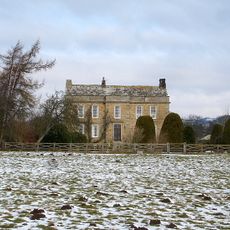
Cotherstone Castle, Medieval castle ruins in Cotherstone, England.

Description

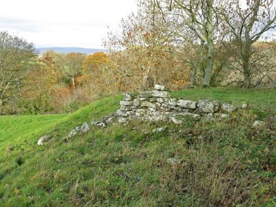
Cotherstone Castle is a medieval fortress in an English village, built on a mound-and-bailey design with earthen fortifications that still define the landscape. The site shows grass-covered mounds and ditches that trace where the defensive walls and structures once stood.

History

The castle was built around 1090 and later received royal permission to add crenellations, confirming its importance as a defensive stronghold in medieval England. It was part of the Norman fortification network that spread across the country after the 1066 conquest.

Culture

The castle site forms part of a network of historical monuments in County Durham that illustrate medieval military architecture and social organization.

Practical

The site is accessible via walking trails that lead across the grassy slopes, making it easy to explore on foot. Information boards are placed around the grounds to help you understand the original layout and features.

Did you know?

The earthworks reveal exactly where the original Norman defenses were positioned, letting visitors see the distinctive shape of a typical medieval fortification layout. This straightforward design was typical of how quickly the Normans built their strongholds after arriving in England.

Location
GPS coordinates
54.57500,-1.97800
Latest update
December 9, 2025 12:27

AroundUs brings together thousands of curated places, local tips, and hidden gems, enriched daily by 60,000 contributors worldwide. Discover all places nearby (Cotherstone).

Around this place
Lartington Hall
United Kingdom

Lartington Hall

2.3 km
Shipley and Great Woods
United Kingdom

Shipley and Great Woods

1.4 km
Mausoleum/Mortuary Chapel 90 Metres North Of Yew Trees
United Kingdom

Mausoleum/Mortuary Chapel 90 Metres North Of Yew Trees

2.2 km
Township Road Marker Stone C.100 Metres South Of Handkerchief Plantation
United Kingdom

Township Road Marker Stone C.100 Metres South Of Handkerchief Plantation

2.3 km
Doe Park
United Kingdom

Doe Park

976 m
The Christening Stone, 160m east of Doe Park
United Kingdom

The Christening Stone, 160m east of Doe Park

832 m
Balder Bridge
United Kingdom

Balder Bridge

608 m
Township Road Marker Stone Opposite Howegill Plantation
United Kingdom

Township Road Marker Stone Opposite Howegill Plantation

2.8 km
High Shipley
United Kingdom

High Shipley

1.7 km
Byres And Loft South-East Of High Shipley
United Kingdom

Byres And Loft South-East Of High Shipley

1.6 km
Woden Croft
United Kingdom

Woden Croft

1.1 km
Township Road Marker Stone Opposite Howegill Plantation
United Kingdom

Township Road Marker Stone Opposite Howegill Plantation

2.8 km
The Grove
United Kingdom

The Grove

2.3 km
Pecknell Farmhouse
United Kingdom

Pecknell Farmhouse

2.6 km
Cotherstone Bridge
United Kingdom

Cotherstone Bridge

303 m
Hallgarth Hill House
United Kingdom

Hallgarth Hill House

221 m
The Green And Front Garden Wall
United Kingdom

The Green And Front Garden Wall

522 m
The Nook
United Kingdom

The Nook

2.3 km
Brook Lea House (Shown On Os Map As Brook House)
United Kingdom

Brook Lea House (Shown On Os Map As Brook House)

477 m
Tower House
United Kingdom

Tower House

2.3 km
Balder Viaduct
United Kingdom

Balder Viaduct

2 km
Garden Wall, With Statues And 2 Sets Of Gate Piers, Adjoining To East Of Lartington Hall
United Kingdom

Garden Wall, With Statues And 2 Sets Of Gate Piers, Adjoining To East Of Lartington Hall

2.3 km
Township Road Marker Stone C.50 Metres East Of Moss Mire
United Kingdom

Township Road Marker Stone C.50 Metres East Of Moss Mire

1.8 km
Outbuilding, 20 Metres West Of The Grove
United Kingdom

Outbuilding, 20 Metres West Of The Grove

2.3 km
The Beeches
United Kingdom

The Beeches

2.3 km
The Woodlands
United Kingdom

The Woodlands

2.2 km
Field Barn, 700 Metres East Of Hunderthwaite Farmhouse
United Kingdom

Field Barn, 700 Metres East Of Hunderthwaite Farmhouse

2.5 km
Gate Piers, End Piers, Gate And Linking Walls At Entrance To Lartington Squash Club
United Kingdom

Gate Piers, End Piers, Gate And Linking Walls At Entrance To Lartington Squash Club

2.3 km
Show the full map
« Cotherstone Castle - Medieval castle ruins in Cotherstone, England » is provided by Around Us (aroundus.com). Images and texts are derived from Wikimedia project under a Creative Commons license. You are allowed to copy, distribute, and modify copies of this page, under the conditions set by the license, as long as this note is clearly visible.

Discover hidden gems everywhere you go!

From secret cafés to breathtaking viewpoints, skip the crowded tourist spots and find places that match your style. Our app makes it easy with voice search, smart filtering, route optimization, and insider tips from travelers worldwide. Download now for the complete mobile experience.

Around Us App Screenshot

A unique approach to discovering new places

Le Figaro

All the places worth exploring

France Info

A tailor-made excursion in just a few clicks

20 Minutes

Around Us
Travel Guide & Maps
Download

Send to your phone

QR Code
1

Open the camera app on your mobile.

2

Point at the QR code with your camera. A notification will appear.

3

Tap the notification to open the link.