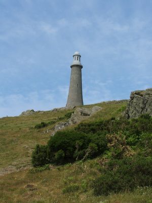
Hoad Monument, Monument building on Hoad Hill in Ulverston, England
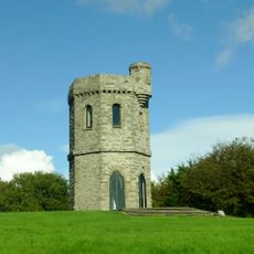
Hoad Monument is a limestone tower standing 100 feet tall on a hilltop above Ulverston, rising prominently above the surrounding landscape and bay. The structure resembles a lighthouse in form, with interior spiral steps and observation windows rather than typical lighthouse features.
Built in 1850 using public funds, the tower was raised to honor a notable figure in British geography and naval history. The choice of lighthouse design reflected the region's connection to maritime exploration and seafaring traditions.
The tower was designed to resemble a real lighthouse yet served only as a memorial, reflecting local pride in the region's maritime heritage and connections to exploration. Today, visitors see it as a symbol of the town's historical importance rather than a practical navigation structure.
Entry is available when the tower is open, requiring visitors to climb more than a hundred spiral steps to reach the viewing platforms inside. The best time to visit is on clear days when views across the bay and surrounding landscape are most rewarding.
The tower underwent major restoration work completed in 2010, which added a copper dome to its roof and strengthened its structural integrity. This renovation gave the building a refreshed appearance while ensuring it remains sound for future visitors.
Location: Ulverston
GPS coordinates: 54.20250,-3.08280
Latest update: December 8, 2025 13:43
Swarthmoor Hall
2.2 km
Conishead Priory
3.4 km
St Mary's Church, Ulverston
694 m
St John the Evangelist's Church, Osmotherley
3.5 km
St Michael's Church, Pennington
3.6 km
Victoria Road drill hall, Ulverston
1.2 km
Coronation Hall
1.2 km
Penny Bridge
4.5 km
Rolling Bridge Over Ulverston Canal And Associated Accumulator Tower
1.4 km
Tower On Hermitage Hill At Sd 3301 4761
3 km
Plumpton Hall
1.9 km
Ulverston War Memorial
1.1 km
Leven Viaduct
2.7 km
Trustee Savings Bank
1 km
Friends Meeting House
2.5 km
Newland Blast Furnace And Attached Ancillary Buildings
830 m
Former Tollhouse In Garden Of Number 45
1.3 km
Barclays Bank
1.2 km
Canal Basin And Pier On Seaward End Of Ulverston Canal,Canal Foot
2.3 km
Devil's Bridge SW of Horrace
3.8 km
Milestone Approximately 23 Metres To North East Of Penny Bridge
4.5 km
Newland blast furnace, blacking mill, associated buildings and water management systems
821 m
Limekiln Approximately 190 Metres South Of Low Frith Farm
4.5 km
Frith Hall
4.4 km
Cartmel Sands
3.5 km
Milestone, Arrad Foot
3.1 km
Milestone, NE of Newland Green
1.5 km
Milestone, Swarthmoor, SW of Three Bridges
2.4 kmVisited this place? Tap the stars to rate it and share your experience / photos with the community! Try now! You can cancel it anytime.
Discover hidden gems everywhere you go!
From secret cafés to breathtaking viewpoints, skip the crowded tourist spots and find places that match your style. Our app makes it easy with voice search, smart filtering, route optimization, and insider tips from travelers worldwide. Download now for the complete mobile experience.
A unique approach to discovering new places❞
— Le Figaro
All the places worth exploring❞
— France Info
A tailor-made excursion in just a few clicks❞
— 20 Minutes