Enable Location

We need your location to show you interesting places around you

Discover nearby places

Find interesting locations and hidden gems around you

Precise directions

Get accurate directions and distances to places

Your location is never shared with other users. It's only used when you tap the location button.

St Mary's Church, Ulverston

Log in to your account

Start exploring — it's free

Trusted by 62,529 travelers worldwide

Continue with Google
Continue with Apple
or

We will send you a code to connect

By continuing, you accept our Terms and Conditions and our Privacy Policy

Check your inbox

We've sent a pincode in your inbox. Please enter the code below.

St Mary's Church, Ulverston

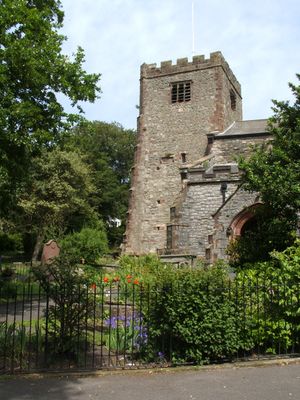
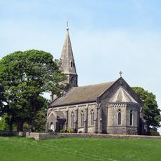
St Mary's Church, Ulverston, Grade II* listed Anglican church in Ulverston, England.

St Mary's Church is an Anglican church in Ulverston with a three-stage west tower built from local limestone and sandstone beneath slate roofs. The structure displays English Gothic and Norman features, including buttresses that support the substantial stonework of this parish building.

This religious site began in 1111, but the current structure took form after a storm destroyed the earlier building. The west tower was erected between 1540 and 1560 during the Renaissance period of rebuilding.

The south chancel aisle became a memorial space in 1923, filled with monuments from different eras that honor those who died in conflicts. This quiet room shows how the community has chosen to preserve and remember loss over many generations.

The interior accommodates around 1,400 visitors and includes modern facilities such as accessible toilets, a refreshment area, and meeting rooms. Recent renovations in 2008 improved accessibility throughout, making a visit more comfortable for everyone.

The bell chamber holds six bells cast by Whitechapel Foundry in 1836, reached by climbing a tight spiral staircase of 34 stone steps. This hidden detail connects the craftsmanship of a renowned bell foundry with an arduous ascent that rewards those curious enough to explore.

The community of curious travelers

AroundUs brings together thousands of curated places, local tips, and hidden gems, enriched daily by 60,000 contributors worldwide.

Start exploring
Location
Architects
Edward Graham Paley
Architectural style
English Gothic architecture, Norman architecture
GPS coordinates
54.19890,-3.09150
Latest update
December 14, 2025 12:20
Around this place
Hoad Monument
United Kingdom

Hoad Monument

694 m
Swarthmoor Hall
United Kingdom

Swarthmoor Hall

1.5 km
Birkrigg stone circle
United Kingdom

Birkrigg stone circle

4.8 km
Conishead Priory
United Kingdom

Conishead Priory

3.3 km
St John the Evangelist's Church, Osmotherley
United Kingdom

St John the Evangelist's Church, Osmotherley

3.6 km
St Michael's Church, Pennington
United Kingdom

St Michael's Church, Pennington

2.9 km
Victoria Road drill hall, Ulverston
United Kingdom

Victoria Road drill hall, Ulverston

635 m
Church of Holy Trinity
United Kingdom

Church of Holy Trinity

4.3 km
Coronation Hall
United Kingdom

Coronation Hall

509 m
Plumpton Hall
United Kingdom

Plumpton Hall

2.4 km
Tower On Hermitage Hill At Sd 3301 4761
United Kingdom

Tower On Hermitage Hill At Sd 3301 4761

2.9 km
Ulverston War Memorial
United Kingdom

Ulverston War Memorial

457 m
Rolling Bridge Over Ulverston Canal And Associated Accumulator Tower
United Kingdom

Rolling Bridge Over Ulverston Canal And Associated Accumulator Tower

1.6 km
Leven Viaduct
United Kingdom

Leven Viaduct

3.2 km
Barclays Bank
United Kingdom

Barclays Bank

549 m
Friends Meeting House
United Kingdom

Friends Meeting House

1.9 km
Newland Blast Furnace And Attached Ancillary Buildings
United Kingdom

Newland Blast Furnace And Attached Ancillary Buildings

1.5 km
Trustee Savings Bank
United Kingdom

Trustee Savings Bank

362 m
Former Tollhouse In Garden Of Number 45
United Kingdom

Former Tollhouse In Garden Of Number 45

616 m
Canal Basin And Pier On Seaward End Of Ulverston Canal,Canal Foot
United Kingdom

Canal Basin And Pier On Seaward End Of Ulverston Canal,Canal Foot

2.6 km
Devil's Bridge SW of Horrace
United Kingdom

Devil's Bridge SW of Horrace

3.3 km
Newland blast furnace, blacking mill, associated buildings and water management systems
United Kingdom

Newland blast furnace, blacking mill, associated buildings and water management systems

1.5 km
Concentric stone circle on Birkrigg Common
United Kingdom

Concentric stone circle on Birkrigg Common

4.7 km
Cartmel Sands
United Kingdom

Cartmel Sands

4.1 km
Milestone, Arrad Foot
United Kingdom

Milestone, Arrad Foot

3.7 km
Milestone, NE of Newland Green
United Kingdom

Milestone, NE of Newland Green

2.2 km
Milestone, Swarthmoor, SW of Three Bridges
United Kingdom

Milestone, Swarthmoor, SW of Three Bridges

1.8 km
Milestone, Pennington; E of Red Syke Bridge
United Kingdom

Milestone, Pennington; E of Red Syke Bridge

3.3 km
Show the full map
« St Mary's Church, Ulverston - Grade II* listed Anglican church in Ulverston, England » is provided by Around Us (aroundus.com). Images and texts are derived from Wikimedia project under a Creative Commons license. You are allowed to copy, distribute, and modify copies of this page, under the conditions set by the license, as long as this note is clearly visible.

Discover hidden gems everywhere you go!

From secret cafés to breathtaking viewpoints, skip the crowded tourist spots and find places that match your style. Our app makes it easy with voice search, smart filtering, route optimization, and insider tips from travelers worldwide. Download now for the complete mobile experience.

Around Us App Screenshot

A unique approach to discovering new places

Le Figaro

All the places worth exploring

France Info

A tailor-made excursion in just a few clicks

20 Minutes

Around Us
Travel Guide & Maps
Download

Send to your phone

QR Code
1

Open the camera app on your mobile.

2

Point at the QR code with your camera. A notification will appear.

3

Tap the notification to open the link.