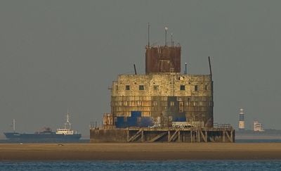
Humber Forts, Sea fort in Humber Estuary, England.
The Humber Forts are two concrete structures consisting of Bull Sand Fort and Haile Sand Fort, standing near the mouth of the Humber where it meets the North Sea. Both installations rise on flat foundations above the water and consist of several floors with gun emplacements and accommodation rooms.
Construction began in 1915 as a response to German attacks along the British coast during World War I. The forts remained operational during both world wars and were only abandoned after 1945.
The name Bull Sand Fort comes from the sandbank on which the structure was built, while Haile Sand Fort takes its name from a nearby shallow. Both installations carry traces of military use today and stand as witnesses to coastal defense that once guarded access to important harbors.
Access to Bull Sand Fort is only possible by boat or helicopter, as it stands about three miles (five kilometers) off Grimsby in open water. The crossing depends on weather and tide conditions, so it helps to check conditions in advance.
A steel mesh barrier was stretched between the two fortifications to prevent enemy submarines from entering the river. Remains of this barrier can still be partially seen on the seabed today.
GPS coordinates: 53.53444,0.03361
Latest update: December 5, 2025 22:30
Cleethorpes Coast Light Railway
3.4 km
Cleethorpes Pier
5 km
St Mary's Church, Grimsby
7.8 km
Council House
4.8 km
Church of St Peter
7.1 km
Beacon Hill round barrow
5.3 km
Spurn Lighthouse
7.5 km
Spurn Point Low Light
7.4 km
Empire Theatre, Cleethorpes
5 km
Church of Saint Peter
3.9 km
Church of St Augustine of Hippo
7.9 km
Church of St Nicholas
5.5 km
Church of St Peter
5 km
Church of St Mary
7.4 km
Church of the Holy Trinity and Holy Mary the Virgin
6.3 km
Church of St Peter and St Paul
6.1 km
Sir Moses Montefiore Synagogue
7.9 km
Ross Castle
4.7 km
Cleethorpes War Memorial
5 km
Former Holme Hill School And Attached Masters House
7.9 km
Humberston War Memorial
3.9 km
Cleethorpes WWII Memorial Hall
5.5 km
RAF North Coates Strike Wing War Memorial, Cleethorpes
4.7 km
The Knoll
4.7 km
Former Air Raid Shelter To Rear Of Numbers 28 And 30
4.9 km
The Old Vicarage
5 km
Railings To Council House Along Cambridge Street Elevation
4.8 km
Cleethorpes Armed Forces Memorial Gate
4.7 kmVisited this place? Tap the stars to rate it and share your experience / photos with the community! Try now! You can cancel it anytime.
Discover hidden gems everywhere you go!
From secret cafés to breathtaking viewpoints, skip the crowded tourist spots and find places that match your style. Our app makes it easy with voice search, smart filtering, route optimization, and insider tips from travelers worldwide. Download now for the complete mobile experience.
A unique approach to discovering new places❞
— Le Figaro
All the places worth exploring❞
— France Info
A tailor-made excursion in just a few clicks❞
— 20 Minutes