Humber Gap, Geological formation in northern England
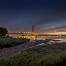
The Humber Gap is a natural landscape division between the Yorkshire Wolds and Lincolnshire Wolds in northern England, where the Humber Estuary creates an extensive body of water. This gap separates two landmasses that are connected by the Humber Bridge, which carries road traffic across the waterway.
The Humber Gap formed after the last ice age when glaciers blocked the area and created an extensive lake system. As the ice melted, water drained away leaving the present river course of the Humber Estuary.
North Ferriby and South Ferriby settlements on opposite sides of the gap maintain traditions connected to the historical river crossing practices.
The area is best accessed from the northern or southern shores of the estuary, where you can view the bridge and water expanse. The best time to visit is in calm weather when you can see the landforms and scale of the waterway more clearly.
The Quaternary deposits in the gap reveal multiple layers of glacial sediments that help experts understand earlier climate shifts. These geological records are windows into the ice age and show how the North Sea basin landscape looked thousands of years ago.
The community of curious travelers
AroundUs brings together thousands of curated places, local tips, and hidden gems, enriched daily by 60,000 contributors worldwide.