Holt Castle, Medieval castle in Holt, Wales
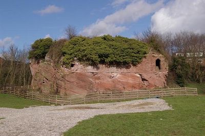
Holt Castle is a pentagonal fortress built on a sandstone ridge near the River Dee in Wales. Five round towers frame the central courtyard, with the ruins rising roughly 33 feet (10 meters) above the surrounding landscape.
Construction began in 1282 under Edward I and John de Warenne to defend newly conquered Welsh lands after defeating Llywelyn ap Gruffydd. The castle served as a military stronghold for centuries, guarding this strategically important border region.
The structure earned the name Castrum Leonis due to the lion motif carved into the stonework above its main entrance gate.
The site is accessible by an easy path that circles the fortress and provides views from multiple angles of its structure. The ground can be muddy after rain, so sturdy footwear is recommended for exploring the ruins.
King Richard II took over the fortress in 1397 and repurposed it from a military stronghold into his personal treasure repository, completely shifting its role. This dramatic change shows how a wartime structure became a place for royal wealth and prestige.
Location: Holt
Inception: 13 century
Elevation above the sea: 8.4 m
Height: 10 m
Made from material: sandstone
Website: http://wrexham.gov.uk/english/heritage/holt_castle.htm
GPS coordinates: 53.07790,-2.88023
Latest update: December 8, 2025 19:44
Farndon Bridge
610 m
St Chad's Church
342 m
St Chad's Church, Farndon
705 m
Churton Hall
2.8 km
Obelisk Commemorating Roger Barnston
1.4 km
Holt English Presbyterian Church
187 m
Chapel House
822 m
Academy House
833 m
Top Farm
843 m
Farndon War Memorial
755 m
Black and White Cottages
789 m
Holt War Memorial (including railings), Wrexham
158 m
Millhey Farmhouse
3.7 km
Stocks
3.6 km
Church View
857 m
Laurel Bank and workshop
790 m
Deebanks
740 m
Pair of adjacent table tombs in churchyard (south of St Chad's Church, east of path to church porch)
755 m
Sunnyside
855 m
Poplar House, with former cartshed and stable
859 m
Higher Farmhouse
3.7 km
Holly Bank, formerly The Doctor's House
738 m
Milepost, N of Farndon, next to South View, between Monument and Briarfield
1.5 km
Milepost, N of Lodge Farm
1.3 km
Milepost, between crossroads with B6130, in front of Milestone House
852 m
Milepost, N of Churton, opp. Walnut Cottage
3.1 km
Milepost, between Farndon Crossroads, jct with A534, nr entrance to Sibbersfield Hall
1.8 km
Milepost, N of Caldecott Green
2.5 kmVisited this place? Tap the stars to rate it and share your experience / photos with the community! Try now! You can cancel it anytime.
Discover hidden gems everywhere you go!
From secret cafés to breathtaking viewpoints, skip the crowded tourist spots and find places that match your style. Our app makes it easy with voice search, smart filtering, route optimization, and insider tips from travelers worldwide. Download now for the complete mobile experience.
A unique approach to discovering new places❞
— Le Figaro
All the places worth exploring❞
— France Info
A tailor-made excursion in just a few clicks❞
— 20 Minutes