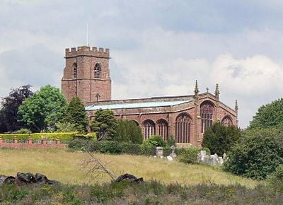
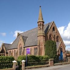
St Chad's Church, Grade I listed church in Holt, Wales.
St Chad's Church is a red sandstone building in Holt featuring English Gothic architecture, with a five-section nave, a two-section chancel, and side aisles running the length of the structure. Listed as Grade I, it displays typical medieval church design with detailed carved elements throughout the interior.
The building was founded around 1280 and underwent major changes in the late 15th century under the patronage of Sir William Stanley. During the Civil War, it suffered damage that remains visible on the walls as bullet marks and sealed openings.
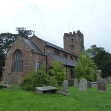
The interior holds a carved baptismal font from 1493 and an ornate table from the 13th century used for altar rituals, showing how worship took shape here over many centuries. These carefully kept objects reveal the religious practices that shaped community life at this location.
The church is located on Church Street in the Wrexham district and remains open to visitors during daylight hours, with regular services held throughout the week. Checking local opening times before visiting helps ensure you can enter and spend time exploring the interior.
Three sealed openings in the north door once served as shooting positions for Civil War soldiers, and musket marks remain etched into the west wall. These direct traces of conflict turn the building's walls into silent witnesses of a turbulent period in the nation's past.
Location: Holt
Inception: 14 century
Architects: Ewan Christian
Architectural style: English Gothic architecture
Elevation above the sea: 15.7 m
GPS coordinates: 53.08090,-2.87913
Latest update: December 14, 2025 14:23
Holt Castle
342 m
Farndon Bridge
279 m
St Chad's Church, Farndon
364 m
Churton Hall
2.4 km
Obelisk Commemorating Roger Barnston
1.1 km
Holt English Presbyterian Church
429 m
Chapel House
480 m
Academy House
491 m
Top Farm
508 m
Farndon War Memorial
413 m
Black and White Cottages
464 m
Holt War Memorial (including railings), Wrexham
273 m
Church View
515 m
Stocks
3.5 km
Millhey Farmhouse
3.6 km
Pair of adjacent table tombs in churchyard (south of St Chad's Church, east of path to church porch)
414 m
Deebanks
413 m
Laurel Bank and workshop
449 m
Sunnyside
513 m
Higher Farmhouse
3.6 km
Poplar House, with former cartshed and stable
518 m
Holly Bank, formerly The Doctor's House
416 m
Milepost, N of Farndon, next to South View, between Monument and Briarfield
1.2 km
Milepost, N of Lodge Farm
1.3 km
Milepost, between crossroads with B6130, in front of Milestone House
617 m
Milepost, N of Churton, opp. Walnut Cottage
2.8 km
Milepost, between Farndon Crossroads, jct with A534, nr entrance to Sibbersfield Hall
1.5 km
Milepost, N of Caldecott Green
2.7 kmVisited this place? Tap the stars to rate it and share your experience / photos with the community! Try now! You can cancel it anytime.
Discover hidden gems everywhere you go!
From secret cafés to breathtaking viewpoints, skip the crowded tourist spots and find places that match your style. Our app makes it easy with voice search, smart filtering, route optimization, and insider tips from travelers worldwide. Download now for the complete mobile experience.
A unique approach to discovering new places❞
— Le Figaro
All the places worth exploring❞
— France Info
A tailor-made excursion in just a few clicks❞
— 20 Minutes