Chest opened
+${chestReward.xp} XP
Explorer
NOUVEAU ×${chestReward.collectible.quantity}
tapez pour fermer
Chest locked

Open chests in the app

Around Us is built for your phone — chests unlock when you walk, explore and capture nearby places.

Enable Location

We need your location to show you interesting places around you

Discover nearby places

Find interesting locations and hidden gems around you

Precise directions

Get accurate directions and distances to places

Your location is never shared with other users. It's only used when you tap the location button.

Log in to your account

Start exploring — it's free

Trusted by 72,986 travelers worldwide

Continue with Google
Continue with Apple
or

We will send you a code to connect

By continuing, you accept our Terms and Conditions and our Privacy Policy

Check your inbox

We've sent a pincode in your inbox. Please enter the code below.

Kinver Edge Hillfort
Discussion Reviews Photo
1.5k Popularity

Kinver Edge Hillfort, Iron Age defensive fort in Kinver, England

Kinver Edge Hillfort is an Iron Age defensive fort located on a high ridge in Staffordshire, protected by substantial earthwork ramparts and a ditch on its south-west and south-east sides. Natural rock cliffs form the remaining defenses, creating a naturally strengthened position.

The fort was built during the Iron Age when communities used its high position to defend and monitor their territory. Archaeological evidence suggests the site functioned as an important defensive outpost over an extended period.

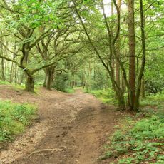
The name Kinver Edge refers to the sharp ridge of the hilltop, a landmark that shaped how people understood their surroundings. Visitors can sense how this elevated location drew communities seeking both protection and control of the land.

Marked trails maintained by the National Trust lead you to the fort, with parking available at Compton Road. The paths are easy to follow and offer good views as you explore the earthworks and surrounding landscape.

On clear days visitors can see across to the Clent Hills and Malvern Hills from this hilltop, which lie several counties away. This expansive view explains why people chose this location for its strategic value.

The community of curious travelers

AroundUs brings together thousands of curated places, local tips, and hidden gems, enriched daily by 60,000 contributors worldwide.

Start exploring
Location
GPS coordinates
52.44750,-2.24280
Latest update
December 14, 2025 14:43
Around this place
Kingsford Country Park
United Kingdom

Kingsford Country Park

1.4 km
Church of St John the Baptist, Wolverley
United Kingdom

Church of St John the Baptist, Wolverley

4.1 km
Church of St Peter
United Kingdom

Church of St Peter

1.1 km
Church of St Mary, Enville
United Kingdom

Church of St Mary, Enville

3.7 km
Church of St Peter
United Kingdom

Church of St Peter

3.2 km
Whittington Inn
United Kingdom

Whittington Inn

2.1 km
Enville Hall
United Kingdom

Enville Hall

3.1 km
Kinver War Memorial
United Kingdom

Kinver War Memorial

412 m
Staffordshire and Worcestershire Canal Pair Of Houses At Stewponey Lock
United Kingdom

Staffordshire and Worcestershire Canal Pair Of Houses At Stewponey Lock

3 km
Dovecote South Of Whittington Hall
United Kingdom

Dovecote South Of Whittington Hall

2.4 km
Oak House, The Court House and The Old School House
United Kingdom

Oak House, The Court House and The Old School House

3.9 km
18, 19 And 20, High Street
United Kingdom

18, 19 And 20, High Street

1.1 km
Ye Olde White Harte
United Kingdom

Ye Olde White Harte

955 m
Stourton Lock Number 2
United Kingdom

Stourton Lock Number 2

3.3 km
Ye Olde Grammar School
United Kingdom

Ye Olde Grammar School

1.3 km
Staffordshire And Worceshire Canal Toll House At Stewponey Lock
United Kingdom

Staffordshire And Worceshire Canal Toll House At Stewponey Lock

3 km
Stourbridge Canal Pair Of Locks At Junction With Staffordshire And Worceshire Canal
United Kingdom

Stourbridge Canal Pair Of Locks At Junction With Staffordshire And Worceshire Canal

3.2 km
Stourbridge Canal Stourton Lock Number 1
United Kingdom

Stourbridge Canal Stourton Lock Number 1

3.5 km
17, High Street
United Kingdom

17, High Street

1.1 km
Milepost At Ngr So 80538754
United Kingdom

Milepost At Ngr So 80538754

5.3 km
The Gate House And Attached Walls And Gate Piers
United Kingdom

The Gate House And Attached Walls And Gate Piers

2.7 km
28 And 29, High Street
United Kingdom

28 And 29, High Street

1 km
North Lodges And Gateway Of Lea Castle
United Kingdom

North Lodges And Gateway Of Lea Castle

3.9 km
Coach House And Stable Block
United Kingdom

Coach House And Stable Block

3.1 km
Milepost, top of Stourton Bank
United Kingdom

Milepost, top of Stourton Bank

2.6 km
Milepost, S of Stowton, nr Dunsley turn
United Kingdom

Milepost, S of Stowton, nr Dunsley turn

2.7 km
Milepost, The Hawthorns, between Wollaston & Stourton
United Kingdom

Milepost, The Hawthorns, between Wollaston & Stourton

4 km
Milepost, Newlands
United Kingdom

Milepost, Newlands

4.1 km
Show the full map
Reviews
Share your experience

No review yet

Discussions
Start a discussion...

No discussion yet

« Kinver Edge Hillfort - Iron Age defensive fort in Kinver, England » is provided by Around Us (aroundus.com). Images and texts are derived from Wikimedia project under a Creative Commons license. You are allowed to copy, distribute, and modify copies of this page, under the conditions set by the license, as long as this note is clearly visible.

Discover hidden gems everywhere you go!

From secret cafés to breathtaking viewpoints, skip the crowded tourist spots and find places that match your style. Our app makes it easy with voice search, smart filtering, route optimization, and insider tips from travelers worldwide. Download now for the complete mobile experience.

Around Us App Screenshot

A unique approach to discovering new places

Le Figaro

All the places worth exploring

France Info

A tailor-made excursion in just a few clicks

20 Minutes

Around Us
Travel Guide & Maps
Download

Send to your phone

QR Code
1

Open the camera app on your mobile.

2

Point at the QR code with your camera. A notification will appear.

3

Tap the notification to open the link.