Chest opened
+${chestReward.xp} XP
Explorer
NOUVEAU ×${chestReward.collectible.quantity}
tapez pour fermer
Chest locked

Open chests in the app

Around Us is built for your phone — chests unlock when you walk, explore and capture nearby places.

Enable Location

We need your location to show you interesting places around you

Discover nearby places

Find interesting locations and hidden gems around you

Precise directions

Get accurate directions and distances to places

Your location is never shared with other users. It's only used when you tap the location button.

Kirkdale sundial

Log in to your account

Start exploring — it's free

Trusted by 74,653 travelers worldwide

Continue with Google
Continue with Apple
or

We will send you a code to connect

By continuing, you accept our Terms and Conditions and our Privacy Policy

Check your inbox

We've sent a pincode in your inbox. Please enter the code below.

Kirkdale sundial
Discussion Reviews 2 Photos
3.1k Popularity

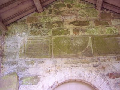
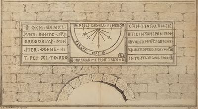
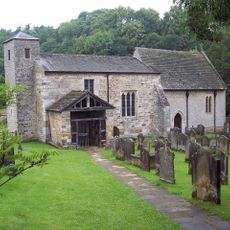
Kirkdale sundial, Medieval sundial at St Gregory's Minster in Kirkdale, England

The Kirkdale sundial is a stone carving with eight equal sections positioned above the main entrance of St Gregory's Church. A central hole marks where a wooden stylus once angled to cast shadows across the dial to show the hours of prayer.

The sundial dates to 1055, created during the reconstruction of St Gregory's Minster by Orm, son of Gamal, under King Edward. This building project marked an important period when the church was renewed and fitted with functional timekeeping tools.

The inscriptions blend Old English and Nordic linguistic elements, reflecting the language of both Anglo-Saxon and Scandinavian communities who lived here. These words carved in stone show how different peoples shared and mixed their speech in daily life.

The sundial sits high on the church wall and is easiest to view during daylight hours from a position where you can see it clearly. The carved inscriptions are more legible when sunlight hits the stone at the right angle.

The inscribed text reads 'This is the day's sun-marker at every time' and appears on a monument older than many comparable European examples. This phrase shows how the clock served not just as a tool but as a religious statement marking sacred hours of worship.

The community of curious travelers

AroundUs brings together thousands of curated places, local tips, and hidden gems, enriched daily by 60,000 contributors worldwide.

Start exploring
Part of
St Gregory's Minster
GPS coordinates
54.26310,-0.96247
Latest update
May 28, 2026 04:46
Around this place
Kirkdale Cave
United Kingdom

Kirkdale Cave

228 m
St Gregory's Minster
United Kingdom

St Gregory's Minster

20 m
United Kingdom

Howkeld Mill

1.1 km
The Plough Inn
United Kingdom

The Plough Inn

1.9 km
Low Hall And Garden Wall Attached To Outbuilding To Left
United Kingdom

Low Hall And Garden Wall Attached To Outbuilding To Left

2.1 km
Village Hall
United Kingdom

Village Hall

1.9 km
The Georgian House And Attached Railings To Front
United Kingdom

The Georgian House And Attached Railings To Front

2 km
United Kingdom

Sundial Approximately 50 Metres South East Of Welburn Hall

1.3 km
Windmill At Rear Of No 17
United Kingdom

Windmill At Rear Of No 17

2.1 km
United Kingdom

Wall, Gate Piers And Gates At Lodge Approximately 400 Metres To North Of Welburn Hall

852 m
83, West End
United Kingdom

83, West End

1.8 km
United Kingdom

Wayside cross called Stony Cross on the A170 920m south east of Highfield House

1.3 km
United Kingdom

Lodge Approximately 100 Metres North West Of Welburn Hall

1.2 km
United Kingdom

Starfits round barrow, 450m north east of Starfits House

1.2 km
United Kingdom

Carter Close

1.9 km
United Kingdom

Lodge Approximately 400 Metres North Of Welburn Hall

863 m
United Kingdom

House To North Of Post Office

1.9 km
United Kingdom

White House Farmhouse

2 km
United Kingdom

Howkeld Mill Cottage

1.1 km
United Kingdom

18 And 20, West End

2.1 km
United Kingdom

Welburn Hall

1.2 km
United Kingdom

Tilehouse Bridge

828 m
United Kingdom

Stable Block Approximately 100 Metres North West Of Welburn Hall

1.1 km
United Kingdom

Garden Pavilion Approximately 50 Metres To South West Of Welburn Hall

1.3 km
United Kingdom

Friends Meeting House At Rear Of 79

1.9 km
United Kingdom

12-20, Dale End

2 km
United Kingdom

10, Dale End

2 km
United Kingdom

Hold Cauldron Mill

1.4 km
Show the full map
Reviews
Share your experience

No review yet

Discussions
Start a discussion...

No discussion yet

« Kirkdale sundial - Medieval sundial at St Gregory's Minster in Kirkdale, England » is provided by Around Us (aroundus.com). Images and texts are derived from Wikimedia project under a Creative Commons license. You are allowed to copy, distribute, and modify copies of this page, under the conditions set by the license, as long as this note is clearly visible.

Discover hidden gems everywhere you go!

From secret cafés to breathtaking viewpoints, skip the crowded tourist spots and find places that match your style. Our app makes it easy with voice search, smart filtering, route optimization, and insider tips from travelers worldwide. Download now for the complete mobile experience.

Around Us App Screenshot

A unique approach to discovering new places

Le Figaro

All the places worth exploring

France Info

A tailor-made excursion in just a few clicks

20 Minutes

Around Us
Travel Guide & Maps
Download

Send to your phone

QR Code
1

Open the camera app on your mobile.

2

Point at the QR code with your camera. A notification will appear.

3

Tap the notification to open the link.