Enable Location

We need your location to show you interesting places around you

Discover nearby places

Find interesting locations and hidden gems around you

Precise directions

Get accurate directions and distances to places

Your location is never shared with other users. It's only used when you tap the location button.

Kirkharle Hall

Log in to your account

Start exploring — it's free

Trusted by 62,927 travelers worldwide

Continue with Google
Continue with Apple
or

We will send you a code to connect

By continuing, you accept our Terms and Conditions and our Privacy Policy

Check your inbox

We've sent a pincode in your inbox. Please enter the code below.

Kirkharle Hall
Discussion Reviews 1 Photos
2.5k Popularity

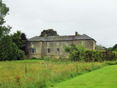
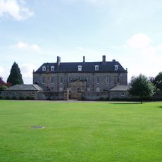
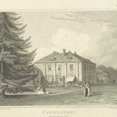
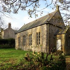
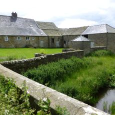
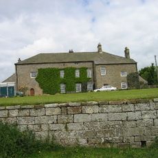
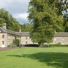
Kirkharle Hall, Grade II listed farmhouse in Kirkharle, England

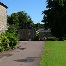
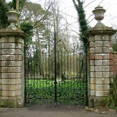
Kirkharle Hall is a stone-built farmhouse in the upper Wansbeck valley, situated east of Hexham in Northumberland. The building and its farm buildings now form the center of a larger courtyard complex housing retail spaces, craft workshops, and historical displays.

The building began as a country house for the Loraine family and was transformed into a farmhouse in the early 19th century following its sale. This change reflected shifting patterns of land use across northern England during that period.

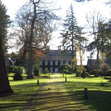
The property connects to Lancelot Brown, who launched his career in gardening and landscape design at the Kirkharle estate in 1732. Brown later became one of England's most influential landscape gardeners of his era.

The site is easily accessible by local roads and offers parking for visitors to the courtyard complex. The various retail and craft spaces are arranged so you can explore them on foot.

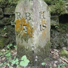
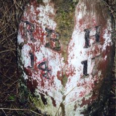
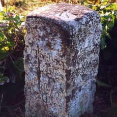
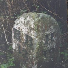
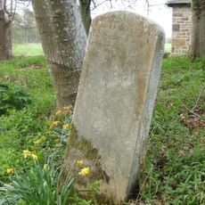
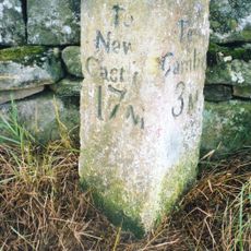
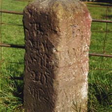
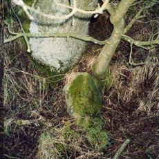
A memorial stone from 1728 near the hall honors Robert Loraine, who was killed by Scottish raiders in 1483. The stone stands as a rare reminder of the violent border conflicts that once shaped this region.

The community of curious travelers

AroundUs brings together thousands of curated places, local tips, and hidden gems, enriched daily by 60,000 contributors worldwide.

Start exploring
Location
GPS coordinates
55.13639,-1.97955
Latest update
December 12, 2025 17:41
Around this place
Bavington Hall
United Kingdom

Bavington Hall

4.3 km
Wallington Hall
United Kingdom

Wallington Hall

2.3 km
Romano-British settlement and Iron Age defended settlement, 550m north east of Shaftoe Grange
United Kingdom

Romano-British settlement and Iron Age defended settlement, 550m north east of Shaftoe Grange

4 km
Capheaton Hall
United Kingdom

Capheaton Hall

3.1 km
Church of St Bartholomew
United Kingdom

Church of St Bartholomew

2.6 km
Church of St Wilfred
United Kingdom

Church of St Wilfred

303 m
Holy Trinity Church
United Kingdom

Holy Trinity Church

3.5 km
Presbyterian Church
United Kingdom

Presbyterian Church

3.7 km
Milestone 50 Metres North Of Gate To Wallington Car Park
United Kingdom

Milestone 50 Metres North Of Gate To Wallington Car Park

2.5 km
Milestone Approx 50 Yards South-East Of East Lodge
United Kingdom

Milestone Approx 50 Yards South-East Of East Lodge

3.4 km
4 Stone Dragons Heads On Lawn East Of Hall
United Kingdom

4 Stone Dragons Heads On Lawn East Of Hall

2.4 km
Milestone 240 Metres West Of Old Deanham
United Kingdom

Milestone 240 Metres West Of Old Deanham

1.9 km
Milestone C 1/4 Mile North Of Knowesgate
United Kingdom

Milestone C 1/4 Mile North Of Knowesgate

4.4 km
Milestone 160 Metres North Of Cambo School
United Kingdom

Milestone 160 Metres North Of Cambo School

3.7 km
Clock Mill Farmhouse
United Kingdom

Clock Mill Farmhouse

1.8 km
Stone 60 Metres West Of West Gate Of Courtyard
United Kingdom

Stone 60 Metres West Of West Gate Of Courtyard

2.2 km
Bridge Over River Wansbeck
United Kingdom

Bridge Over River Wansbeck

2.4 km
East Shaftoe Hall
United Kingdom

East Shaftoe Hall

4.5 km
Clock Tower Gate
United Kingdom

Clock Tower Gate

2.4 km
North-east Courtyard Range And Courtyard Wall
United Kingdom

North-east Courtyard Range And Courtyard Wall

2.4 km
Milepost On West Side Of Road Opposite Track To Corridge
United Kingdom

Milepost On West Side Of Road Opposite Track To Corridge

4.8 km
Sir Walter's Privy In East Wood
United Kingdom

Sir Walter's Privy In East Wood

2.7 km
North-west Courtyard Range And Courtyard Wall
United Kingdom

North-west Courtyard Range And Courtyard Wall

2.3 km
Walled Garden With Gateways
United Kingdom

Walled Garden With Gateways

2.9 km
Milestone On South Side Of Road At Ngr Nz 03628419
United Kingdom

Milestone On South Side Of Road At Ngr Nz 03628419

2.8 km
Milestone 40 Metres North Of Crossroads
United Kingdom

Milestone 40 Metres North Of Crossroads

2.8 km
Milestone, Bavington
United Kingdom

Milestone, Bavington

3.5 km
Milestone, Kirkharle
United Kingdom

Milestone, Kirkharle

764 m
Show the full map
Reviews
Share your experience

No review yet

Discussions
Start a discussion...

No discussion yet

« Kirkharle Hall - Grade II listed farmhouse in Kirkharle, England » is provided by Around Us (aroundus.com). Images and texts are derived from Wikimedia project under a Creative Commons license. You are allowed to copy, distribute, and modify copies of this page, under the conditions set by the license, as long as this note is clearly visible.

Discover hidden gems everywhere you go!

From secret cafés to breathtaking viewpoints, skip the crowded tourist spots and find places that match your style. Our app makes it easy with voice search, smart filtering, route optimization, and insider tips from travelers worldwide. Download now for the complete mobile experience.

Around Us App Screenshot

A unique approach to discovering new places

Le Figaro

All the places worth exploring

France Info

A tailor-made excursion in just a few clicks

20 Minutes

Around Us
Travel Guide & Maps
Download

Send to your phone

QR Code
1

Open the camera app on your mobile.

2

Point at the QR code with your camera. A notification will appear.

3

Tap the notification to open the link.