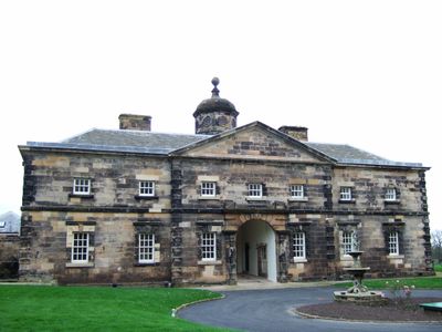
Lathom House, English country house in Lathom, England
Lathom House is an English country house in Lathom with a surviving west wing from the 18th century displaying Palladian architecture characterized by symmetrical facades and classical proportions. The former noble residence was adapted over time and now contains residential apartments, preserving parts of its historic structure.
The house was built as a noble residence and gained historical significance during the English Civil War in 1644, when Charlotte Stanley defended it with 300 defenders against Parliamentary forces until Prince Rupert arrived to help. After the conflict, it returned to civilian use and served as a private residence for generations.
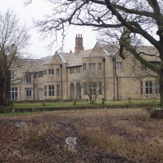
The estate reflected the social order of English landed gentry, with noble families employing large numbers of servants, gardeners, and local workers within its walls. This structure shaped daily life and relationships across different ranks living and working on the property.
The estate is now partially occupied by residential apartments, so visitor access is limited to certain outdoor areas and heritage features. Check local regulations before visiting to understand what sections are publicly accessible and respect the privacy of current residents.
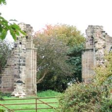
The landscape design incorporated principles developed by Humphry Repton, a celebrated landscape architect of the period, with an extensive deer park surrounding the original mansion. This combination of architecture and carefully designed grounds was characteristic of 18th-century country estates.
Location: Lathom
Inception: 1740
GPS coordinates: 53.57580,-2.81700
Latest update: December 8, 2025 19:56
Blythe Hall, Lathom
2.3 km
Burscough Priory
2.7 km
Tower Hill Water Tower
3.7 km
St Paul's Church, Skelmersdale
3.3 km
St John's Church, Burscough
3.5 km
Bath Lodge
3.4 km
Church of St Michael
3.7 km
Church of St James
3.1 km
Moss Bridge
1.8 km
Junction Bridge At Top Locks (That Part In Lathom) Leeds And Liverpool Canal Junction Bridge At Top Locks (That Part In Burscough)
2.5 km
Alder Lane Bridge (Number 38) Leeds And Liverpool Canal Alder Lane Bridge (Number 38)
3.7 km
Runnel Brow Bridge (That Part In Burscough) Runnel Brow Bridge (That Part In Lathom)
2.8 km
Parbold Library
3.6 km
Lathom War Memorial
802 m
Canal Aqueduct
2.8 km
Skelmersdale War Memorial
2.8 km
Leeds And Liverpool Canal Top Locks, Upper Lock (That Part In Burscough) Top Locks, Upper Lock (That Part In Lathom)
2.6 km
Lathom and Burscough War Memorial
3.2 km
Newburgh War Memorial
2.5 km
Post Office
2.5 km
Junction Bridge Canal Basin And Former Dry Dock, Top Locks (That Part In Lathom) Leeds And Liverpool Canal Junction Bridge Canal Basin And Former Dry Dock, Top Locks (That Part In Burscough)
2.5 km
Parbold Cabin Signal Box
3.5 km
Briars Brook Culvert
2.2 km
Parbold Mill
3.4 km
Canal Lock Approximately 50 Metres North Of Runnel Brow Bridge (That Part In Burscough) Canal Lock Approximately 50 Metres North Of Runnel Brow Bridge (That Part In Lathom)
2.8 km
Burscough Bridge Railway Station Building On North Side Of Track
3.7 km
Canal Aqueduct
2.6 km
Village Cross On The Green
2.6 kmVisited this place? Tap the stars to rate it and share your experience / photos with the community! Try now! You can cancel it anytime.
Discover hidden gems everywhere you go!
From secret cafés to breathtaking viewpoints, skip the crowded tourist spots and find places that match your style. Our app makes it easy with voice search, smart filtering, route optimization, and insider tips from travelers worldwide. Download now for the complete mobile experience.
A unique approach to discovering new places❞
— Le Figaro
All the places worth exploring❞
— France Info
A tailor-made excursion in just a few clicks❞
— 20 Minutes