Lea Hall, Wimboldsley

Log in to your account

AroundUs is a community-driven map of interesting places, built by curious explorers like you. It grows with every review, story, and photo you share.
Connect to save your favorite spots, contribute locations, and create personalized routes.
By continuing, you accept our Terms and Conditions and our Privacy Policy
Add to collection
Map
Suggest a change
Share

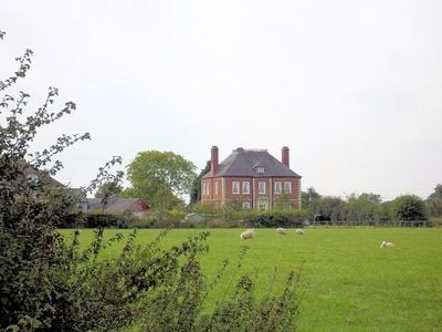
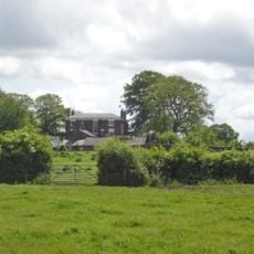
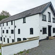
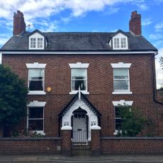
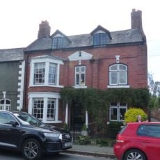
Lea Hall, Wimboldsley, 18th-century country house in Wimboldsley, England

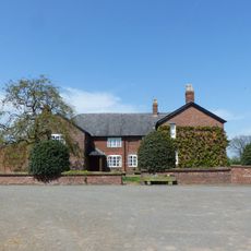
Lea Hall is a red brick mansion from the early 1700s in Wimboldsley, structured with five matching bays across two stories. The building includes a basement level, upper attic space, and a tiled roof topped with a small viewing platform.

The house was built in the early 1700s for the Lowndes family, representing the architectural style of that time. Ownership later passed to Joseph Verdin, who made modifications that included adding dormer windows to the roofline.

The central entrance displays ornamental details with initials that mark the house's connection to its inhabitants over time. These touches reveal how owners expressed their status through architectural choices in rural settings.

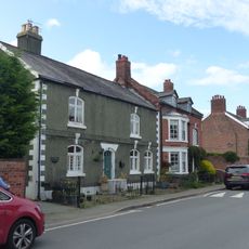
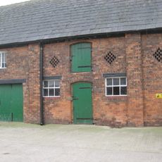
The building is now divided into three private flats, so visitors should plan accordingly if seeking exterior views or photography. Its listed building status means it is protected and not typically open for interior tours, making external inspection the best option.

The Buildings of England series describes this Georgian structure as a perfect brick box, highlighting its mathematically precise proportions. This description captures how architects of the era pursued symmetry and order as fundamental design principles.

Location: Wimboldsley

GPS coordinates: 53.17350,-2.47968

Latest update: December 14, 2025 18:07

Photos
Around this place
Christ Church, Wharton
United Kingdom

Christ Church, Wharton

3 km
Stanthorne Hall
United Kingdom

Stanthorne Hall

2.4 km
Middlewich Manor
United Kingdom

Middlewich Manor

2.1 km
Middlewich Branch Canal Bridge Number 18 at SJ 679 621
United Kingdom

Middlewich Branch Canal Bridge Number 18 at SJ 679 621

2 km
Hollingshead Bridge
United Kingdom

Hollingshead Bridge

2.8 km
Ashbrook Bridge
United Kingdom

Ashbrook Bridge

2.9 km
Trent and Mersey Canal Bridge Number 167
United Kingdom

Trent and Mersey Canal Bridge Number 167

3 km
Cooke family tomb in Middlewich Cemetery circa 80 metres south of mortuary chapels
United Kingdom

Cooke family tomb in Middlewich Cemetery circa 80 metres south of mortuary chapels

3 km
Wardle Lock
United Kingdom

Wardle Lock

3 km
Middlewich Branch of Shropshire Union Canal: Bridge Number 31 carrying Sutton Lane over canal
United Kingdom

Middlewich Branch of Shropshire Union Canal: Bridge Number 31 carrying Sutton Lane over canal

2.9 km
Lee Green Hall
United Kingdom

Lee Green Hall

2.7 km
Middlewich Branch of Shropshire Union Canal: Bridge Number 28 carrying footpath over canal
United Kingdom

Middlewich Branch of Shropshire Union Canal: Bridge Number 28 carrying footpath over canal

2.5 km
Middlewich Branch of Shropshire Union: Canal Bridge Number 30 carrying St Ann's Road over canal
United Kingdom

Middlewich Branch of Shropshire Union: Canal Bridge Number 30 carrying St Ann's Road over canal

2.8 km
Gates and railings to Middlewich Cemetery
United Kingdom

Gates and railings to Middlewich Cemetery

2.9 km
Middlewich Branch canal bridge Number 19 at 680 624
United Kingdom

Middlewich Branch canal bridge Number 19 at 680 624

1.7 km
Milepost, Nantwich Road jct with School Lane
United Kingdom

Milepost, Nantwich Road jct with School Lane

1 km
Stanthorne Mill
United Kingdom

Stanthorne Mill

2.5 km
Trent and Mersey Canal King's Lock
United Kingdom

Trent and Mersey Canal King's Lock

3 km
Sutton Hall Farmhouse
United Kingdom

Sutton Hall Farmhouse

2 km
Milepost
United Kingdom

Milepost

2.9 km
66, St Ann's Road
United Kingdom

66, St Ann's Road

2.7 km
62, St Ann's Road
United Kingdom

62, St Ann's Road

2.8 km
Nantwich Road Aqueduct
United Kingdom

Nantwich Road Aqueduct

2.4 km
8, Southway
United Kingdom

8, Southway

2.9 km
64, St Ann's Road
United Kingdom

64, St Ann's Road

2.7 km
Barn C15 Yards To West Of Twelve Acres Farmhouse
United Kingdom

Barn C15 Yards To West Of Twelve Acres Farmhouse

868 m
Milepost, S of Sheriff House
United Kingdom

Milepost, S of Sheriff House

1.5 km
Milepost, E of Birch Lane jct
United Kingdom

Milepost, E of Birch Lane jct

2.8 km
Show the full map
Reviews

Visited this place? Tap the stars to rate it and share your experience / photos with the community! Try now! You can cancel it anytime.

« Lea Hall, Wimboldsley - 18th-century country house in Wimboldsley, England » is provided by Around Us (aroundus.com). Images and texts are derived from Wikimedia project under a Creative Commons license. You are allowed to copy, distribute, and modify copies of this page, under the conditions set by the license, as long as this note is clearly visible.

Discover hidden gems everywhere you go!

From secret cafés to breathtaking viewpoints, skip the crowded tourist spots and find places that match your style. Our app makes it easy with voice search, smart filtering, route optimization, and insider tips from travelers worldwide. Download now for the complete mobile experience.

Around Us App Screenshot

A unique approach to discovering new places

Le Figaro

All the places worth exploring

France Info

A tailor-made excursion in just a few clicks

20 Minutes