·

Enable Location

We need your location to show you interesting places around you

Discover nearby places

Find interesting locations and hidden gems around you

Precise directions

Get accurate directions and distances to places

Your location is never shared with other users. It's only used when you tap the location button.

Lower Tamar Lake

Log in to your account

Start exploring — it's free

Trusted by 62,656 travelers worldwide

Continue with Google
Continue with Apple
or

We will send you a code to connect

By continuing, you accept our Terms and Conditions and our Privacy Policy

Check your inbox

We've sent a pincode in your inbox. Please enter the code below.

Lower Tamar Lake

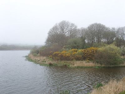
Lower Tamar Lake, reservoir in Devon, England, UK

Lower Tamar Lake is a reservoir straddling the border between Devon and Cornwall with calm waters and grassy banks dotted with scattered trees. The lake features 15 fishing swims along flat, wide paths that are accessible to everyone.

The lake was created in the 1820s to supply water to the Bude Canal, which transported goods across the countryside. The dam shaped the region during the industrial era and helped support local trade routes.

The lake sits on the border between Devon and Cornwall and is valued by locals as a retreat for quiet days in nature. The area draws people who enjoy fishing or simply want to experience the stillness of the countryside.

The shoreline has flat access with parking, toilets, and showers nearby, making a comfortable visit easy. Season tickets and day passes can be purchased online in advance, and the area suits visitors with mobility needs.

The lake holds carp that can weigh up to 40 pounds, drawing anglers trying to land these sizeable fish. It occasionally hosts fishing competitions and events that bring activity to the otherwise quiet waters.

The community of curious travelers

AroundUs brings together thousands of curated places, local tips, and hidden gems, enriched daily by 60,000 contributors worldwide.

Start exploring
Location
Location
Elevation above the sea
133 m
GPS coordinates
50.87300,-4.42500
Latest update
February 9, 2026 07:46
Around this place
Penstowe Castle
United Kingdom

Penstowe Castle

5.2 km
Church of St James
United Kingdom

Church of St James

4.2 km
Church of St John the Baptist
United Kingdom

Church of St John the Baptist

4.2 km
Church of St Andrew
United Kingdom

Church of St Andrew

5.3 km
Church of St Pancras
United Kingdom

Church of St Pancras

5.2 km
Bradworthy Inn
United Kingdom

Bradworthy Inn

4.2 km
Alfardisworthy Well
United Kingdom

Alfardisworthy Well

814 m
Woodsdown Cottages
United Kingdom

Woodsdown Cottages

2.7 km
Sutcombe War Memorial
United Kingdom

Sutcombe War Memorial

5.2 km
Kilkhampton War Memorial
United Kingdom

Kilkhampton War Memorial

4.2 km
The Rectory
United Kingdom

The Rectory

4.7 km
Algernon Carteret Thynne monument, Kilkhampton
United Kingdom

Algernon Carteret Thynne monument, Kilkhampton

4.2 km
Milestone, just S of 30mph sign
United Kingdom

Milestone, just S of 30mph sign

4.4 km
Kingsford Mill
United Kingdom

Kingsford Mill

5.1 km
Bowl barrow on Ugworthy Moor 510m south of West Ugworthy House
United Kingdom

Bowl barrow on Ugworthy Moor 510m south of West Ugworthy House

4.4 km
Milestone At Ngr Ss 3009 0520
United Kingdom

Milestone At Ngr Ss 3009 0520

5.8 km
Milestone, N of Hersham
United Kingdom

Milestone, N of Hersham

4.5 km
Replacement Milestone, Shernick Farm entrance, E of Red Post
United Kingdom

Replacement Milestone, Shernick Farm entrance, E of Red Post

6.2 km
Milestone, N of Stursdon Cross
United Kingdom

Milestone, N of Stursdon Cross

4.7 km
Milestone, N of Launcells Cross, opp. Wesleyan Church
United Kingdom

Milestone, N of Launcells Cross, opp. Wesleyan Church

5.4 km
Milestone, Crimp
United Kingdom

Milestone, Crimp

5.9 km
Milestone, Bush, cutting on old road over Hunthill
United Kingdom

Milestone, Bush, cutting on old road over Hunthill

6.4 km
Milestone, just N of East Thorne Touring Park (East Thorne Farm)
United Kingdom

Milestone, just N of East Thorne Touring Park (East Thorne Farm)

3.4 km
Milestone, opp. drive to Lewdon farm, start of green lane
United Kingdom

Milestone, opp. drive to Lewdon farm, start of green lane

3.5 km
Milestone, Barnacott, lay-by (the old road)
United Kingdom

Milestone, Barnacott, lay-by (the old road)

5.4 km
Milestone, Taylors Cross, N of Kilkhampton
United Kingdom

Milestone, Taylors Cross, N of Kilkhampton

3.7 km
Milestone, S of Red Post, beside Bude Canal
United Kingdom

Milestone, S of Red Post, beside Bude Canal

6.8 km
Milestone, Woolley, just S of Bradworthy turn
United Kingdom

Milestone, Woolley, just S of Bradworthy turn

6.5 km
Show the full map
« Lower Tamar Lake - reservoir in Devon, England, UK » is provided by Around Us (aroundus.com). Images and texts are derived from Wikimedia project under a Creative Commons license. You are allowed to copy, distribute, and modify copies of this page, under the conditions set by the license, as long as this note is clearly visible.

Discover hidden gems everywhere you go!

From secret cafés to breathtaking viewpoints, skip the crowded tourist spots and find places that match your style. Our app makes it easy with voice search, smart filtering, route optimization, and insider tips from travelers worldwide. Download now for the complete mobile experience.

Around Us App Screenshot

A unique approach to discovering new places

Le Figaro

All the places worth exploring

France Info

A tailor-made excursion in just a few clicks

20 Minutes

Around Us
Travel Guide & Maps
Download

Send to your phone

QR Code
1

Open the camera app on your mobile.

2

Point at the QR code with your camera. A notification will appear.

3

Tap the notification to open the link.