Enable Location

We need your location to show you interesting places around you

Discover nearby places

Find interesting locations and hidden gems around you

Precise directions

Get accurate directions and distances to places

Your location is never shared with other users. It's only used when you tap the location button.

Penstowe Castle

Log in to your account

Start exploring — it's free

Trusted by 63,484 travelers worldwide

Continue with Google
Continue with Apple
or

We will send you a code to connect

By continuing, you accept our Terms and Conditions and our Privacy Policy

Check your inbox

We've sent a pincode in your inbox. Please enter the code below.

Penstowe Castle
Discussion Reviews 1 Photos
1.6k Popularity

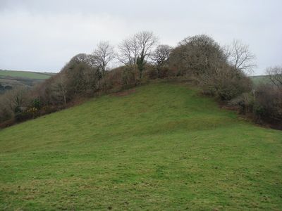
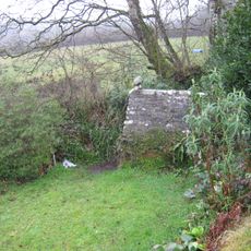
Penstowe Castle, Medieval castle ruins in Kilkhampton, England.

Penstowe Castle is a medieval fortress ruin in Kilkhampton, with a mound measuring 18 meters long and 8 meters wide. The steep slopes on the northern and southern sides create the characteristic motte-and-bailey design typical of Norman defensive structures.

The castle was built during the 12th century civil war, likely by Robert, First Earl of Gloucester, or the Grenville family. Excavations in the 1950s uncovered building remains and pottery from that period.

This medieval structure represents the architectural methods and military strategies employed during England's feudal period through its motte and bailey design.

The site is open and free to explore, offering views of the archaeological remains of a Norman earthwork system. Visitors should note that the steep slopes of the mound can be slippery, especially after rain.

The site features an uncommon bailey layout that mirrors features seen at nearby Eastleigh Berries Castle. These two Norman fortresses allow for comparison of regional defensive designs from the 12th century.

The community of curious travelers

AroundUs brings together thousands of curated places, local tips, and hidden gems, enriched daily by 60,000 contributors worldwide.

Start exploring
Location
GPS coordinates
50.87690,-4.49931
Latest update
December 9, 2025 12:28
Around this place
Stowe House, Kilkhampton
United Kingdom

Stowe House, Kilkhampton

2.9 km
Church of St Morwenna and St John the Baptist, Morwenstow
United Kingdom

Church of St Morwenna and St John the Baptist, Morwenstow

5.3 km
Sandymouth Beach
United Kingdom

Sandymouth Beach

4.3 km
St Olaf's Church, Bude
United Kingdom

St Olaf's Church, Bude

4.3 km
Lower Tamar Lake
United Kingdom

Lower Tamar Lake

5.2 km
St Andrew's Church, Bude
United Kingdom

St Andrew's Church, Bude

5.2 km
Duckpool to Furzey Cove
United Kingdom

Duckpool to Furzey Cove

4.6 km
Church of St James
United Kingdom

Church of St James

1 km
Alfardisworthy Well
United Kingdom

Alfardisworthy Well

5.1 km
Stratton War Memorial
United Kingdom

Stratton War Memorial

5.3 km
Holy well of St John about 125 – metres south east of the Church of St Morwenna
United Kingdom

Holy well of St John about 125 – metres south east of the Church of St Morwenna

5.2 km
Stile, lychgate and former mortuary adjoining lychgate at south about 20m south-east of the Church of St Morwenna
United Kingdom

Stile, lychgate and former mortuary adjoining lychgate at south about 20m south-east of the Church of St Morwenna

5.2 km
Rectory Farmhouse
United Kingdom

Rectory Farmhouse

5.1 km
Kilkhampton War Memorial
United Kingdom

Kilkhampton War Memorial

1 km
Algernon Carteret Thynne monument, Kilkhampton
United Kingdom

Algernon Carteret Thynne monument, Kilkhampton

1.1 km
Duckpool Beach
United Kingdom

Duckpool Beach

4.1 km
Milestone, just S of 30mph sign
United Kingdom

Milestone, just S of 30mph sign

1 km
The Vicarage
United Kingdom

The Vicarage

5.3 km
K6 Telephone Kiosk, Poughill
United Kingdom

K6 Telephone Kiosk, Poughill

4.4 km
Milestone, N of Stursdon Cross
United Kingdom

Milestone, N of Stursdon Cross

2.6 km
Milestone, N of Hersham
United Kingdom

Milestone, N of Hersham

4 km
Milestone, Barnacott, lay-by (the old road)
United Kingdom

Milestone, Barnacott, lay-by (the old road)

2 km
Milestone, Bush, cutting on old road over Hunthill
United Kingdom

Milestone, Bush, cutting on old road over Hunthill

3.4 km
Milestone, just N of East Thorne Touring Park (East Thorne Farm)
United Kingdom

Milestone, just N of East Thorne Touring Park (East Thorne Farm)

1.8 km
Milestone, opp. drive to Lewdon farm, start of green lane
United Kingdom

Milestone, opp. drive to Lewdon farm, start of green lane

2.9 km
Milestone, Taylors Cross, N of Kilkhampton
United Kingdom

Milestone, Taylors Cross, N of Kilkhampton

1.9 km
Milestone, on line of old main road, NW of Townsend
United Kingdom

Milestone, on line of old main road, NW of Townsend

4.9 km
Milestone, Crimp
United Kingdom

Milestone, Crimp

3.9 km
Show the full map
Reviews
Share your experience

No review yet

Discussions
Start a discussion...

No discussion yet

« Penstowe Castle - Medieval castle ruins in Kilkhampton, England » is provided by Around Us (aroundus.com). Images and texts are derived from Wikimedia project under a Creative Commons license. You are allowed to copy, distribute, and modify copies of this page, under the conditions set by the license, as long as this note is clearly visible.

Discover hidden gems everywhere you go!

From secret cafés to breathtaking viewpoints, skip the crowded tourist spots and find places that match your style. Our app makes it easy with voice search, smart filtering, route optimization, and insider tips from travelers worldwide. Download now for the complete mobile experience.

Around Us App Screenshot

A unique approach to discovering new places

Le Figaro

All the places worth exploring

France Info

A tailor-made excursion in just a few clicks

20 Minutes

Around Us
Travel Guide & Maps
Download

Send to your phone

QR Code
1

Open the camera app on your mobile.

2

Point at the QR code with your camera. A notification will appear.

3

Tap the notification to open the link.