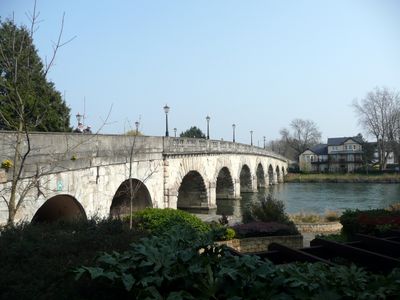
Maidenhead Bridge, Grade I listed bridge in Maidenhead, England
Maidenhead Bridge is an arched stone crossing with thirteen spans that stretches across the river between two counties while carrying the A4 road. The Portland stone structure features elegantly curved arches that frame the water below and functions as an important route for both traffic and people on foot.
The present crossing was built in the late 1700s and replaced a much older timber structure that had served the area for many centuries. This new stone construction strengthened the importance of the route as a major pathway between eastern and western England.
The stone crossing defines the landscape through its classical architecture and becomes a natural focal point for anyone walking along the river. Its presence shapes how people experience this part of the Thames Valley today.
Pedestrians can walk across using the Thames Path, which runs alongside the vehicle carriageway of the A4 road. Wind gusts can be strong over the water during changeable weather, so care is needed when crossing.
From the late 1700s until the early 1900s, the crossing operated as a toll point and generated revenue from travelers crossing between the two banks. This arrangement ended only after officials discovered that the collected fees had been subject to abuse and mismanagement.
The community of curious travelers
AroundUs brings together thousands of curated places, local tips, and hidden gems, enriched daily by 60,000 contributors worldwide.