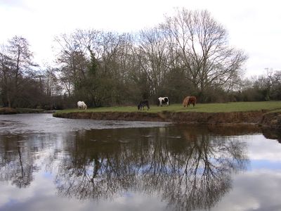
Lymington River, Protected waterway in Hampshire, England.
The Lymington River is a waterway in Hampshire that flows through the New Forest and extends over several kilometers. It gathers water from several tributaries before reaching the coastal area and plays an important role in the local water system.
The river was shaped by human activities in the past, such as bridge construction, which altered the natural flow of water. These changes left marks on the landscape and defined the relationship between people and nature at this location.
The river supports diverse bird and fish populations, and visitors can observe several species thriving in the shallow waters and along the banks. Local communities use the waterway for leisure activities like riverside walks and wildlife watching.
The river is best accessed on foot via paths that run along the banks and offer good views of the water. It is wise to wear comfortable shoes and pay attention to the tides, as they can affect water depth and access to certain areas.
The river is designated as a protected area of special scientific importance, preserving its undisturbed natural processes and plant diversity. This classification allows researchers to study how river landscapes function without heavy human interference.
Location: Hampshire
Location: Lymington and Pennington
GPS coordinates: 50.75000,-1.53333
Latest update: December 12, 2025 08:00
Lymington Open Air Sea Water Baths
475 m
Church of St. Thomas the Apostle
1.2 km
Hurst Castle And Lymington River Estuary
1.1 km
Church of All Saints
500 m
United Reform Church
1.1 km
Baptist Church
1.2 km
Standwell House Hotel Stanwell House Hotel
1.1 km
Lymington Community Centre
1.3 km
Walhampton Arms, formerly farm building range at Home Farm
2 km
Burrard-Neale Memorial Gas Lamp
569 m
Burard-neale Monument
1.3 km
The King's Head Public House
1.1 km
The Angel Hotel
1.1 km
Garden wall to Elm Grove House
970 m
Wood End
1.1 km
Drinking Fountain
614 m
Lloyds Bank
1.1 km
No 1, 3 And 5 And Cast Iron Bollard Against No 1 At Junction Of Gosport Street And Quay Hill
1.1 km
No 6 And Band Of Stone Paving On West Sides
1.1 km
Hill House
1.4 km
16-18, High Street
1.1 km
Quay Hill Surface
1.1 km
Monmouth House (including The Former Office Of The Clerk To The Justices)
1.2 km
Ivy House No 63 And Area Railings Twynham House
1.2 km
102 And 103, High Street
1.1 km
36 And 37, High Street
1.1 km
29, High Street
1.1 km
Milestone, Pennington
1.6 kmVisited this place? Tap the stars to rate it and share your experience / photos with the community! Try now! You can cancel it anytime.
Discover hidden gems everywhere you go!
From secret cafés to breathtaking viewpoints, skip the crowded tourist spots and find places that match your style. Our app makes it easy with voice search, smart filtering, route optimization, and insider tips from travelers worldwide. Download now for the complete mobile experience.
A unique approach to discovering new places❞
— Le Figaro
All the places worth exploring❞
— France Info
A tailor-made excursion in just a few clicks❞
— 20 Minutes