Enable Location

We need your location to show you interesting places around you

Discover nearby places

Find interesting locations and hidden gems around you

Precise directions

Get accurate directions and distances to places

Your location is never shared with other users. It's only used when you tap the location button.

Milecastle 25

Log in to your account

Start exploring — it's free

Trusted by 62,925 travelers worldwide

Continue with Google
Continue with Apple
or

We will send you a code to connect

By continuing, you accept our Terms and Conditions and our Privacy Policy

Check your inbox

We've sent a pincode in your inbox. Please enter the code below.

Milecastle 25
Discussion Reviews 1 Photos
1.2k Popularity

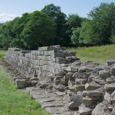
Milecastle 25, Roman fortress in Northumberland, England

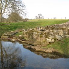
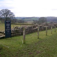
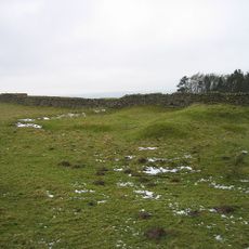
Milecastle 25 is a small Roman fortification positioned along Hadrian's Wall in Northumberland. The stone ruins still display the foundations and passages that allowed Roman soldiers to keep watch over the frontier from this strategic point.

This fortification was built between 122 and 128 AD during Emperor Hadrian's reign as a checkpoint on the northern frontier of the Roman Empire. It formed part of a larger defensive system designed to control movement across the border.

Archaeological excavations at the site have uncovered pottery fragments, tools, and military equipment that demonstrate the daily routines of Roman soldiers stationed there.

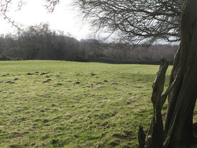
The site is easily reached via marked walking trails with parking areas nearby for visitors. The location sits on open moorland and remains accessible year-round without restrictions.

The site had two additional watchtowers positioned between neighboring milecastles, creating a dense surveillance network along the border. This arrangement shows how the Romans systematically strengthened their control over the region.

The community of curious travelers

AroundUs brings together thousands of curated places, local tips, and hidden gems, enriched daily by 60,000 contributors worldwide.

Start exploring
Location
Part of
Hadrian's Wall
GPS coordinates
55.01918,-2.08611
Latest update
December 14, 2025 18:46
Around this place
Chesters Bridge
United Kingdom

Chesters Bridge

3.3 km
Planetrees
United Kingdom

Planetrees

1.7 km
Chollerford Bridge
United Kingdom

Chollerford Bridge

2.9 km
Milecastle 26
United Kingdom

Milecastle 26

1.5 km
Milecastle 27
United Kingdom

Milecastle 27

3 km
Milecastle 23
United Kingdom

Milecastle 23

3 km
Milecastle 24
United Kingdom

Milecastle 24

1.5 km
Church of St Peter
United Kingdom

Church of St Peter

3.3 km
Church of St Oswald
United Kingdom

Church of St Oswald

907 m
Church of St George
United Kingdom

Church of St George

2.9 km
Church of St Giles
United Kingdom

Church of St Giles

2.9 km
The George Inn
United Kingdom

The George Inn

2.9 km
Milestone 420 Metres East Of St Oswalds Hill Head Farm
United Kingdom

Milestone 420 Metres East Of St Oswalds Hill Head Farm

223 m
Churchyard Wall To Church Of St Oswald
United Kingdom

Churchyard Wall To Church Of St Oswald

868 m
Wall War Memorial
United Kingdom

Wall War Memorial

2.9 km
Cocklaw Tower
United Kingdom

Cocklaw Tower

1.9 km
Errington Farmhouse And Garden Wall To West
United Kingdom

Errington Farmhouse And Garden Wall To West

2.6 km
Milestone 230 Metres East Of High Brunton
United Kingdom

Milestone 230 Metres East Of High Brunton

1.8 km
Farmbuilding C50 Yards East Of Chollerton Farmhouse
United Kingdom

Farmbuilding C50 Yards East Of Chollerton Farmhouse

2.9 km
Footbridge Over The Birkey Burn 220 Metres South Of Acomb House
United Kingdom

Footbridge Over The Birkey Burn 220 Metres South Of Acomb House

3.4 km
Pant With Adjacent Hydrant
United Kingdom

Pant With Adjacent Hydrant

3.2 km
Hadrian's Wall and vallum between St Oswald's Cottages, east of Brunton Gate and the North Tyne in wall miles 25, 26 and 27
United Kingdom

Hadrian's Wall and vallum between St Oswald's Cottages, east of Brunton Gate and the North Tyne in wall miles 25, 26 and 27

2.2 km
Hydrant 5 Metres South-West Of Cartshed South Of Fold Cottage
United Kingdom

Hydrant 5 Metres South-West Of Cartshed South Of Fold Cottage

3.2 km
Milestone 360 Metres North Of B6318 Junction
United Kingdom

Milestone 360 Metres North Of B6318 Junction

2.4 km
Railway Bridge 300 Yards South Of Chollerton
United Kingdom

Railway Bridge 300 Yards South Of Chollerton

2.6 km
Garden Wall To West End Terrace And Evans Almshouse, With Attached Pant
United Kingdom

Garden Wall To West End Terrace And Evans Almshouse, With Attached Pant

3.4 km
Milestone, Errington Hill Head, Whittington Fell
United Kingdom

Milestone, Errington Hill Head, Whittington Fell

1.4 km
Milestone, S edge of Chollerton
United Kingdom

Milestone, S edge of Chollerton

2.6 km
Show the full map
Reviews
Share your experience

No review yet

Discussions
Start a discussion...

No discussion yet

« Milecastle 25 - Roman fortress in Northumberland, England » is provided by Around Us (aroundus.com). Images and texts are derived from Wikimedia project under a Creative Commons license. You are allowed to copy, distribute, and modify copies of this page, under the conditions set by the license, as long as this note is clearly visible.

Discover hidden gems everywhere you go!

From secret cafés to breathtaking viewpoints, skip the crowded tourist spots and find places that match your style. Our app makes it easy with voice search, smart filtering, route optimization, and insider tips from travelers worldwide. Download now for the complete mobile experience.

Around Us App Screenshot

A unique approach to discovering new places

Le Figaro

All the places worth exploring

France Info

A tailor-made excursion in just a few clicks

20 Minutes

Around Us
Travel Guide & Maps
Download

Send to your phone

QR Code
1

Open the camera app on your mobile.

2

Point at the QR code with your camera. A notification will appear.

3

Tap the notification to open the link.