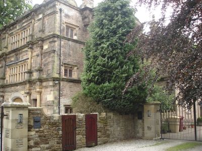
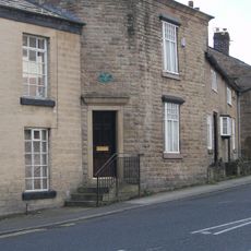
Lostock Hall Gatehouse, 16th-century gatehouse in Lostock, England.
Lostock Hall Gatehouse is a stone structure featuring a central archway on its ground level and classical columns on the upper floors. The main facade displays carefully cut stone blocks with multiple column styles, reflecting the craftsmanship of that period.
Built in 1591 during Queen Elizabeth I's reign, this structure served as the entrance to Lostock Hall estate. The Anderton family, who owned the property, eventually lost it, but this gatehouse survived while the rest of the original complex disappeared.
The carved stone emblems on the walls represent royal authority and local nobility, telling you about the power structures that shaped rural life at that time. These symbols connected the Anderton family to the broader political order of their era.
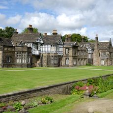
The building sits on Hall Lane in Bolton and now serves as a private residence. You can view it from the street and appreciate its architectural details from the outside, but remember to respect the privacy of those living there.
This gatehouse is the sole survivor from the original estate and displays different stone-working techniques on different sides. The main facade uses finely shaped blocks, while other sides are built with roughly finished stone, reflecting different priorities during construction.
Location: Bolton
GPS coordinates: 53.58640,-2.49230
Latest update: December 14, 2025 17:03
Toughsheet Community Stadium
2.9 km
Smithills Hall
3 km
Bolton Steam Museum
2.5 km
St. Mary the Virgin, Deane
2.7 km
St Margaret's Church, Halliwell
2.4 km
Church of St Peter
1.8 km
Church of St Paul
3.1 km
Hulton Memorial In St Marys Churchyard
2.7 km
Statue of Benjamin Disraeli
3.2 km
The Finishers Arms (Number 487) And Numbers 489-493
1.7 km
Victoria Row Numbers 2-16 St Pauls Place
3.1 km
Christchurch
1.3 km
George Marsh Memorial In St Marys Churchyard
2.7 km
Fox And Stork Public House
3 km
1st and 5th Loyal North Lancashire Regiment Cenotaph
3.1 km
St Pauls School (South Of Church)
3.1 km
591 And 593, Halliwell Road
3 km
St Pauls School (North Of Church)
3.1 km
Bryan Hey Farmhouse
3.1 km
Statue of J. T. Fielding
3.2 km
Chimney At Junction With Moss Lane
2.3 km
Albert Row Numbers 1-11 St Pauls Place
3.1 km
759,759A And 761-773, Chorley Old Road
1.4 km
Milestone, Smithills Dean Road, by No. 93 - about 1/4 N from the A58 Ring Road Moss Bank Way
2.8 km
Milestone, Colliers Row Road - 200m W of the cross roads with Smithills Dean Road, Scout Road and Coal Pit Road
2.8 km
Milestone, Chorley Old Road, 250m NW of the Bob Smithy Inn, at the cross roads with Walker Fold Road / Old Kiln Lane
1.1 km
Milestone, Chorley New Road, 70m E jnct with Whinslee Drive
837 m
Milestone, Moss Bank Park
1.9 kmVisited this place? Tap the stars to rate it and share your experience / photos with the community! Try now! You can cancel it anytime.
Discover hidden gems everywhere you go!
From secret cafés to breathtaking viewpoints, skip the crowded tourist spots and find places that match your style. Our app makes it easy with voice search, smart filtering, route optimization, and insider tips from travelers worldwide. Download now for the complete mobile experience.
A unique approach to discovering new places❞
— Le Figaro
All the places worth exploring❞
— France Info
A tailor-made excursion in just a few clicks❞
— 20 Minutes