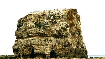
Marsden Rock, Limestone sea stack in South Shields, England.
Marsden Rock is a Magnesian Limestone formation standing approximately 27 meters (89 feet) high and about 91 meters (300 feet) from the main cliff face off South Shields. The stack rises from the seabed and creates a distinctive landmark along this stretch of the Durham coast.
The rock formation developed through natural erosion of the limestone cliffs over thousands of years. A natural arch spanning the formation collapsed during winter storms in 1996, splitting it into two separate stacks, with the smaller section removed in 1997.
The cliffs surrounding this formation host one of Northeast England's largest seabird colonies, where kittiwakes, fulmars, and razorbills nest and make their home.
The rock is accessible on foot during low tide but becomes completely surrounded by water as the tide rises. Always check tidal conditions before visiting and avoid going out in rough weather or when water levels are high.
In 1903, multiple choirs climbed to the top of this rock to perform a musical service, making it one of the most unusual concert venues ever used. This remarkable event remains part of local memory and speaks to how people once found creative ways to use natural spaces.
Location: Tyne and Wear
GPS coordinates: 54.97750,-1.37528
Latest update: December 8, 2025 19:52
Souter Lighthouse
1.1 km
Municipal Buildings
4 km
St Hilda's Church, South Shields
4.5 km
The Word
4.6 km
South Shields Museum And Art Gallery
4.3 km
Tynemouth North Pier light
4.5 km
Tyne South Pier light
4.1 km
Parish Church
3.3 km
Church of All Saints
3 km
Statue of Queen Victoria
3.7 km
St. Peter's Church
2.5 km
St Jude’s Church Rekendyke
4 km
Ocean Beach Pleasure Park
3.8 km
South Shields Volunteer Life Brigage Watch House
4 km
Cleadon House
4.4 km
South Shields Old Town Hall
4.6 km
Cleadon War Memorial
3.1 km
Littlehaven Beach
4.3 km
Combined Engine And Boiler Houses, Adjacent Coal Store, Engineman's House And Cottage At Cleadon Pumping Station
2 km
Westovian Theatre Pier Pavilion
3.6 km
Cleadon Mill
2.1 km
East-West Wall 35 Metres South Of Red Cottage And Linking Wall To House
3.4 km
Whitburn War Memorial
3.2 km
Souter Point Lighthouse Foghorn To East Of Lighthouse And Steps And Walls To East Of Lighthouse
1.1 km
Detached Chimney At Cleadon Pumping Station
1.9 km
Souter Lighthouse foghorn
1.1 km
No 52 (Olde House) And Coach House Adjoining To East
3.2 km
River Tyne, River Police Offices
4.6 kmVisited this place? Tap the stars to rate it and share your experience / photos with the community! Try now! You can cancel it anytime.
Discover hidden gems everywhere you go!
From secret cafés to breathtaking viewpoints, skip the crowded tourist spots and find places that match your style. Our app makes it easy with voice search, smart filtering, route optimization, and insider tips from travelers worldwide. Download now for the complete mobile experience.
A unique approach to discovering new places❞
— Le Figaro
All the places worth exploring❞
— France Info
A tailor-made excursion in just a few clicks❞
— 20 Minutes