Enable Location

We need your location to show you interesting places around you

Discover nearby places

Find interesting locations and hidden gems around you

Precise directions

Get accurate directions and distances to places

Your location is never shared with other users. It's only used when you tap the location button.

Nether Horsburgh Castle

Log in to your account

Start exploring — it's free

Trusted by 62,594 travelers worldwide

Continue with Google
Continue with Apple
or

We will send you a code to connect

By continuing, you accept our Terms and Conditions and our Privacy Policy

Check your inbox

We've sent a pincode in your inbox. Please enter the code below.

Nether Horsburgh Castle

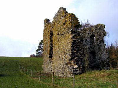
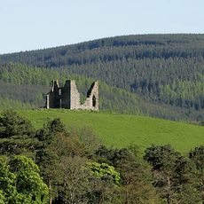
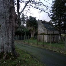
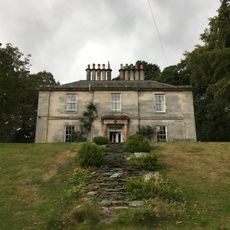
Nether Horsburgh Castle, Tower house in Innerleithen, Scotland.

Nether Horsburgh Castle is a rectangular stone tower house in Innerleithen with three surviving walls that reach approximately 12 meters high and contain remnants of a vaulted cellar and window openings. The structure displays the typical defensive design of a tower house from this period, with narrow slit windows and a ground-level entrance on the north wall.

The tower was built in the 16th century by the Horsburgh family as a defensive structure in a contested border region. Following financial difficulties, ownership passed to Sir Robert Stewart of Shillingshaws.

The castle functioned as a communication point in a network of watchtowers along the Tweed valley, enabling message transmission across the Scottish Borders.

The site sits on private farmland and requires advance permission from Nether Horsburgh Farm for access. The ruins are protected as a scheduled monument, so visitors should tread carefully to avoid disturbing the stonework.

The structure features ground-level entrance in the north wall, leading to a barrel-vaulted room illuminated by strategic slit windows.

The community of curious travelers

AroundUs brings together thousands of curated places, local tips, and hidden gems, enriched daily by 60,000 contributors worldwide.

Start exploring
Location
Location
GPS coordinates
55.64490,-3.10740
Latest update
December 9, 2025 12:27
Around this place
Kailzie Gardens
United Kingdom

Kailzie Gardens

2.2 km
Horsburgh Castle
United Kingdom

Horsburgh Castle

1.9 km
Kailzie Gardens
United Kingdom

Kailzie Gardens

2.5 km
Leithen Lodge
United Kingdom

Leithen Lodge

3.6 km
Bridge, Leithen Water, Innerleithen Golf Club
United Kingdom

Bridge, Leithen Water, Innerleithen Golf Club

3.3 km
Old Bridge, Innerleithen
United Kingdom

Old Bridge, Innerleithen

3.8 km
Memorial Hall, Leithen Road
United Kingdom

Memorial Hall, Leithen Road

3.9 km
Bridge And Lade, Sluice, Leithen Water, Mills, Innerleithen
United Kingdom

Bridge And Lade, Sluice, Leithen Water, Mills, Innerleithen

3.4 km
Innerleithen, Well's Brae, St Ronan's Well
United Kingdom

Innerleithen, Well's Brae, St Ronan's Well

3.4 km
Innerleithen, High Street, St James R.c. Church
United Kingdom

Innerleithen, High Street, St James R.c. Church

4 km
Janet's Brae
United Kingdom

Janet's Brae

3.7 km
Cardrona, Railway Viaduct
United Kingdom

Cardrona, Railway Viaduct

1.7 km
Horsburgh Railway Viaduct
United Kingdom

Horsburgh Railway Viaduct

756 m
Innerleithen, 91 High Street, St James' R.c. Church, School
United Kingdom

Innerleithen, 91 High Street, St James' R.c. Church, School

4 km
Municipal Buildings, Leithen Road
United Kingdom

Municipal Buildings, Leithen Road

3.9 km
Kailzie House, Dovecot
United Kingdom

Kailzie House, Dovecot

2.4 km
St Andrews Episcopal Church Including Boundary Walls And Gates, Church Street
United Kingdom

St Andrews Episcopal Church Including Boundary Walls And Gates, Church Street

3.8 km
91 High Street And St James Hall (Formerly St James Rc School And Schoolhouse) Including Boundary Walls
United Kingdom

91 High Street And St James Hall (Formerly St James Rc School And Schoolhouse) Including Boundary Walls

4 km
Kailzie House, Stables
United Kingdom

Kailzie House, Stables

2.5 km
Howford House
United Kingdom

Howford House

3.6 km
Sluice, Leithen Water
United Kingdom

Sluice, Leithen Water

3.4 km
Game Larders, Kailzie House
United Kingdom

Game Larders, Kailzie House

2.4 km
Former Congregational Chapel, Alpinebikes, Peebles Road
United Kingdom

Former Congregational Chapel, Alpinebikes, Peebles Road

3.9 km
Tiendside, St Ronan's Terrace
United Kingdom

Tiendside, St Ronan's Terrace

3.6 km
Caerlee
United Kingdom

Caerlee

3.5 km
St Ronan's View, 40- 48 (Even Nos) High Street
United Kingdom

St Ronan's View, 40- 48 (Even Nos) High Street

4 km
Bank Of Scotland, 2 High Street
United Kingdom

Bank Of Scotland, 2 High Street

4 km
Cardrona footbridge
United Kingdom

Cardrona footbridge

1.6 km
Show the full map
« Nether Horsburgh Castle - Tower house in Innerleithen, Scotland » is provided by Around Us (aroundus.com). Images and texts are derived from Wikimedia project under a Creative Commons license. You are allowed to copy, distribute, and modify copies of this page, under the conditions set by the license, as long as this note is clearly visible.

Discover hidden gems everywhere you go!

From secret cafés to breathtaking viewpoints, skip the crowded tourist spots and find places that match your style. Our app makes it easy with voice search, smart filtering, route optimization, and insider tips from travelers worldwide. Download now for the complete mobile experience.

Around Us App Screenshot

A unique approach to discovering new places

Le Figaro

All the places worth exploring

France Info

A tailor-made excursion in just a few clicks

20 Minutes

Around Us
Travel Guide & Maps
Download

Send to your phone

QR Code
1

Open the camera app on your mobile.

2

Point at the QR code with your camera. A notification will appear.

3

Tap the notification to open the link.