Ilkley Roman Fort, Roman military fort in Ilkley, England.
Ilkley Roman Fort is a military installation located on high ground south of the River Wharfe, where soldiers lived and worked in an organized settlement. The site contained barracks, storage buildings, workshops, and an officer's residence, all arranged within a fortified perimeter.
The fort was established around 80 AD under Emperor Titus and served as a key military outpost for several centuries. It was gradually abandoned between the 4th and 5th centuries as Roman rule withdrew from Britain.
The place name comes from the Roman name Olicana, which has stayed in local memory across the centuries. Visitors walking through today can still sense the presence of the soldiers who once lived and worked here.
Parts of the western wall remain visible near the local museum, which provides information panels about the fort's layout and history. Comfortable footwear is recommended as the site requires walking across open ground to view the different sections.
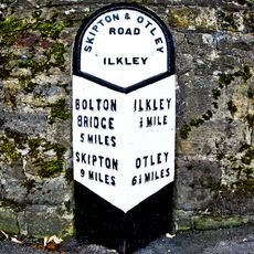
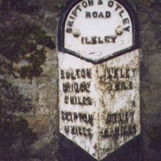
The fort was a junction in a network of roads that connected Roman settlements across northern Britain, making it a central hub for moving goods and information. This strategic position meant soldiers and travelers from different parts of the empire regularly passed through.
The community of curious travelers
AroundUs brings together thousands of curated places, local tips, and hidden gems, enriched daily by 60,000 contributors worldwide.