Enable Location

We need your location to show you interesting places around you

Discover nearby places

Find interesting locations and hidden gems around you

Precise directions

Get accurate directions and distances to places

Your location is never shared with other users. It's only used when you tap the location button.

Porlock Bay

Log in to your account

Start exploring — it's free

Trusted by 62,050 travelers worldwide

Continue with Google
Continue with Apple
or

We will send you a code to connect

By continuing, you accept our Terms and Conditions and our Privacy Policy

Check your inbox

We've sent a pincode in your inbox. Please enter the code below.

Porlock Bay, Protected coastal bay in Somerset, England

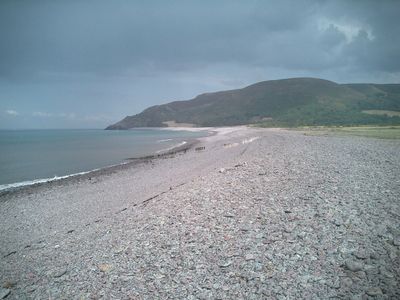
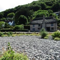
Porlock Bay is a coastal inlet located between Hurlstone Point and Porlock Weir, characterized by a long shingle ridge and extensive salt marshes along the Bristol Channel. The bay features wide tidal flats that expose at low tide, creating distinct zones for different plant and animal life.

In 1052, the Saxon king Harold landed at this location after sailing from Ireland and set fire to the local settlement before traveling onward to London. This event marks a dramatic moment in early medieval English history along the Somerset coast.

The National Trust maintains the coastline, incorporating it into the South West Coast Path network for long-distance walking routes.

The location offers excellent birding opportunities during spring and autumn migrations when species such as ospreys, spoonbills, and turnstones pass through the area. Designated viewing points provide comfortable vantage spots for observing these visiting birds.

At low tide, visitors can spot remains of a submerged ancient forest that once grew inland until rising sea levels flooded the landscape around 8,000 years ago. The exposed tree stumps provide a tangible connection to the region's geological past.

The community of curious travelers

AroundUs brings together thousands of curated places, local tips, and hidden gems, enriched daily by 60,000 contributors worldwide.

Start exploring
GPS coordinates
51.21930,-3.60508
Latest update
December 12, 2025 09:05
Around this place
Culbone Church
United Kingdom

Culbone Church

3.8 km
Church of St Dubricius, Porlock
United Kingdom

Church of St Dubricius, Porlock

1.4 km
Holnicote Estate
United Kingdom

Holnicote Estate

3.3 km
Coleridge Way
United Kingdom

Coleridge Way

2.2 km
Church of All Saints
United Kingdom

Church of All Saints

4.1 km
Bury Castle
United Kingdom

Bury Castle

3.8 km
Hawkcombe Woods
United Kingdom

Hawkcombe Woods

2.1 km
Dovery Manor Museum
United Kingdom

Dovery Manor Museum

1.4 km
West Somerset Rural Life Museum and Victorian School
United Kingdom

West Somerset Rural Life Museum and Victorian School

2.6 km
Lynch Chapel of Ease
United Kingdom

Lynch Chapel of Ease

2 km
The Ship Inn
United Kingdom

The Ship Inn

1.2 km
Periwinkle Cottage Tea Rooms
United Kingdom

Periwinkle Cottage Tea Rooms

4.1 km
Remains of churchyard cross
United Kingdom

Remains of churchyard cross

4.1 km
Horner packhorse bridge
United Kingdom

Horner packhorse bridge

2.9 km
Selworthy War Memorial Cross
United Kingdom

Selworthy War Memorial Cross

4.1 km
Westbourne Cottage
United Kingdom

Westbourne Cottage

4 km
Stables And Linhay Abutting West Lynch Farmhouse Returned To South
United Kingdom

Stables And Linhay Abutting West Lynch Farmhouse Returned To South

2 km
West Luccombe packhorse bridge
United Kingdom

West Luccombe packhorse bridge

2.6 km
Allerford packhorse bridge
United Kingdom

Allerford packhorse bridge

2.7 km
Beach Cottage
United Kingdom

Beach Cottage

1.5 km
Cottage (National Trust Estate No 68)
United Kingdom

Cottage (National Trust Estate No 68)

4.1 km
Gatehouse and Gatehouse Cottage, Holnicote Estate
United Kingdom

Gatehouse and Gatehouse Cottage, Holnicote Estate

3.5 km
Barn And Round House At West Lynch Farm Park
United Kingdom

Barn And Round House At West Lynch Farm Park

2 km
West Lynch House, Dwarf Wall And Railings Returned To House As Curved Walls
United Kingdom

West Lynch House, Dwarf Wall And Railings Returned To House As Curved Walls

2.1 km
Lorna Doone  National Trust Shop And Information Centre
United Kingdom

Lorna Doone National Trust Shop And Information Centre

4.1 km
The Whit Stones: two standing stones 230m west of Whitstone Post
United Kingdom

The Whit Stones: two standing stones 230m west of Whitstone Post

3.1 km
Porlock Library
United Kingdom

Porlock Library

1.2 km
Doverhay Reading Room And Cottage Abutting North End
United Kingdom

Doverhay Reading Room And Cottage Abutting North End

1.4 km
Show the full map
« Porlock Bay - Protected coastal bay in Somerset, England » is provided by Around Us (aroundus.com). Images and texts are derived from Wikimedia project under a Creative Commons license. You are allowed to copy, distribute, and modify copies of this page, under the conditions set by the license, as long as this note is clearly visible.

Discover hidden gems everywhere you go!

From secret cafés to breathtaking viewpoints, skip the crowded tourist spots and find places that match your style. Our app makes it easy with voice search, smart filtering, route optimization, and insider tips from travelers worldwide. Download now for the complete mobile experience.

Around Us App Screenshot

A unique approach to discovering new places

Le Figaro

All the places worth exploring

France Info

A tailor-made excursion in just a few clicks

20 Minutes

Around Us
Travel Guide & Maps
Download

Send to your phone

QR Code
1

Open the camera app on your mobile.

2

Point at the QR code with your camera. A notification will appear.

3

Tap the notification to open the link.