Enable Location

We need your location to show you interesting places around you

Discover nearby places

Find interesting locations and hidden gems around you

Precise directions

Get accurate directions and distances to places

Your location is never shared with other users. It's only used when you tap the location button.

Knypersley Reservoir

Log in to your account

Start exploring — it's free

Trusted by 64,894 travelers worldwide

Continue with Google
Continue with Apple
or

We will send you a code to connect

By continuing, you accept our Terms and Conditions and our Privacy Policy

Check your inbox

We've sent a pincode in your inbox. Please enter the code below.

Knypersley Reservoir
Discussion Reviews 1 Photos
5.1k Popularity

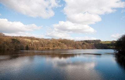
Knypersley Reservoir, reservoir in Staffordshire, England, UK

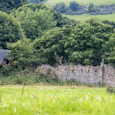
Knypersley Reservoir is a freshwater reservoir near Biddulph in Staffordshire, England, set within a wooded valley with low hills on either side. A network of paths follows the shoreline and continues into the surrounding woodland, connecting open grassy areas with quieter, tree-covered spots.

The reservoir was built in the early 1800s to supply water to the Caldon Canal, which was used to move goods across the region. Thomas Telford, the engineer behind many British waterways of that era, was involved in its design.

The reservoir sits within a country park that draws families and walkers from nearby towns, especially on weekends. The shoreline paths and wooded areas give people a natural setting for everyday outdoor activities like dog walking and birdwatching.

The paths around the reservoir are wide and easy to follow, making the area accessible for most visitors including families with children. There are no cafes or shops on site, so it is a good idea to bring your own food and drink.

During dam repairs in 2006, workers found the remains of an old mill dam beneath the water, left over from a watermill that existed before the reservoir was created. This shows that the valley was already being used to harness water long before the canal era.

The community of curious travelers

AroundUs brings together thousands of curated places, local tips, and hidden gems, enriched daily by 60,000 contributors worldwide.

Start exploring
Location
Location
Elevation above the sea
171 m
GPS coordinates
53.09413,-2.15738
Latest update
March 3, 2026 10:07
Around this place
Chatterley Whitfield Colliery
United Kingdom

Chatterley Whitfield Colliery

2.4 km
The Ashes
United Kingdom

The Ashes

3.7 km
Church of St Anne
United Kingdom

Church of St Anne

1.6 km
Church of St Luke, Endon
United Kingdom

Church of St Luke, Endon

3.5 km
Christ Church
United Kingdom

Christ Church

3.3 km
Biddulph Methodist Church
United Kingdom

Biddulph Methodist Church

2.9 km
Church of St John the Evangelist
United Kingdom

Church of St John the Evangelist

2.2 km
Church of St Bartholomew
United Kingdom

Church of St Bartholomew

3.8 km
Garden Gateway To Biddulph Grange Approximately 70 Metres South East Of Church Of St Lawrence  Garden Gateway To Biddulph Grange, Approximately 70 Metres South East Of Church Of St Lawrence
United Kingdom

Garden Gateway To Biddulph Grange Approximately 70 Metres South East Of Church Of St Lawrence Garden Gateway To Biddulph Grange, Approximately 70 Metres South East Of Church Of St Lawrence

3.8 km
Prospect Tower And Attached Wing
United Kingdom

Prospect Tower And Attached Wing

168 m
St James the Apostle
United Kingdom

St James the Apostle

3.4 km
Biddulph War Memorial
United Kingdom

Biddulph War Memorial

2.9 km
Biddulph Library
United Kingdom

Biddulph Library

2.7 km
Hill Top Methodist Church
United Kingdom

Hill Top Methodist Church

3.1 km
Milestone in front of 161 Congleton Road
United Kingdom

Milestone in front of 161 Congleton Road

3.3 km
Knypersley School  Knypersley School, Attached Archway And Frontage Wall
United Kingdom

Knypersley School Knypersley School, Attached Archway And Frontage Wall

2.2 km
Biddulph Primary Care Centre
United Kingdom

Biddulph Primary Care Centre

2.7 km
Red Cross, Approximately 2 Metres West Of Church Of St John
United Kingdom

Red Cross, Approximately 2 Metres West Of Church Of St John

2.2 km
Brindley Ford War Memorial
United Kingdom

Brindley Ford War Memorial

1.7 km
Crowborough Farmhouse
United Kingdom

Crowborough Farmhouse

1.9 km
Milepost At Sj 923 528
United Kingdom

Milepost At Sj 923 528

3.7 km
Milepost Outside 'Kings Croft', West Of Endon Village
United Kingdom

Milepost Outside 'Kings Croft', West Of Endon Village

3.1 km
Chatterley Whitfield: Pithead Baths Complex (18-21)
United Kingdom

Chatterley Whitfield: Pithead Baths Complex (18-21)

2.2 km
Biddulph Town Hall
United Kingdom

Biddulph Town Hall

2.8 km
Biddulph Millennium Garden
United Kingdom

Biddulph Millennium Garden

2.9 km
Biddulph Leisure Centre
United Kingdom

Biddulph Leisure Centre

2.9 km
Milepost, between Norton Green & Norton-in-the-Moors, W of Endon village
United Kingdom

Milepost, between Norton Green & Norton-in-the-Moors, W of Endon village

3.2 km
Milepost, W of Endon village
United Kingdom

Milepost, W of Endon village

3.1 km
Show the full map
Reviews
Share your experience

No review yet

Discussions
Start a discussion...

No discussion yet

« Knypersley Reservoir - reservoir in Staffordshire, England, UK » is provided by Around Us (aroundus.com). Images and texts are derived from Wikimedia project under a Creative Commons license. You are allowed to copy, distribute, and modify copies of this page, under the conditions set by the license, as long as this note is clearly visible.

Discover hidden gems everywhere you go!

From secret cafés to breathtaking viewpoints, skip the crowded tourist spots and find places that match your style. Our app makes it easy with voice search, smart filtering, route optimization, and insider tips from travelers worldwide. Download now for the complete mobile experience.

Around Us App Screenshot

A unique approach to discovering new places

Le Figaro

All the places worth exploring

France Info

A tailor-made excursion in just a few clicks

20 Minutes

Around Us
Travel Guide & Maps
Download

Send to your phone

QR Code
1

Open the camera app on your mobile.

2

Point at the QR code with your camera. A notification will appear.

3

Tap the notification to open the link.